- Oake
-
Coordinates: 51°01′21″N 3°12′22″W / 51.0226°N 3.2061°W
Oake 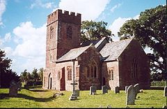
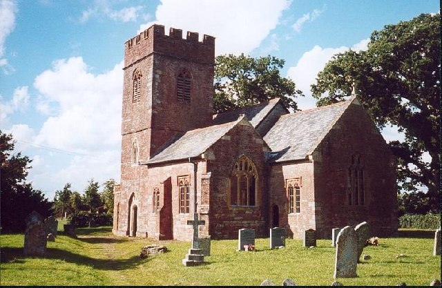
Church of St Bartholonew, Oake
 Oake
Oake
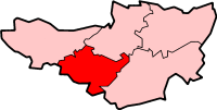
Oake shown within SomersetPopulation 695 [1] OS grid reference ST155255 District Taunton Deane Shire county Somerset Region South West Country England Sovereign state United Kingdom Post town TAUNTON Postcode district TA4 Dialling code 01823 Police Avon and Somerset Fire Devon and Somerset Ambulance South Western EU Parliament South West England UK Parliament Taunton Deane List of places: UK • England • Somerset Oake is a village and civil parish in Somerset, England, situated 5 miles (8.0 km) west of Taunton in the Taunton Deane district. The village has a population of 695.[1]
The parish includes the hamlet of Hillfarrance on Hillfarrance Brook a tributary of the River Tone, and the villages of Hillcommon and Heathfield.
The Sustrans cycle route 3 from Bristol to Padstow passes through the village, as does the route of the Grand Western Canal.
Contents
History
The village was named Acon in 897 based on the early presence of Oak trees. From Saxon times it formed part of the manor of Taunton Deane which belonged to the Bishop of Winchester.[2]
The parishes of Heathfield and Hillfarrance were part of the Taunton Deane Hundred.[3]
Governance
The parish council has responsibility for local issues, including setting an annual precept (local rate) to cover the council’s operating costs and producing annual accounts for public scrutiny. The parish council evaluates local planning applications and works with the local police, district council officers, and neighbourhood watch groups on matters of crime, security, and traffic. The parish council's role also includes initiating projects for the maintenance and repair of parish facilities, as well as consulting with the district council on the maintenance, repair, and improvement of highways, drainage, footpaths, public transport, and street cleaning. Conservation matters (including trees and listed buildings) and environmental issues are also the responsibility of the council.
The village falls within the Non-metropolitan district of Taunton Deane, which was formed on April 1, 1974 under the Local Government Act 1972, having previously been part of Wellington Rural District.[4] The district council is responsible for local planning and building control, local roads, council housing, environmental health, markets and fairs, refuse collection and recycling, cemeteries and crematoria, leisure services, parks, and tourism.
Somerset County Council is responsible for running the largest and most expensive local services such as education, social services, libraries, main roads, public transport, policing and fire services, trading standards, waste disposal and strategic planning.
It is also part of the Taunton Deane county constituency represented in the House of Commons of the Parliament of the United Kingdom. It elects one Member of Parliament (MP) by the first past the post system of election, and part of the South West England constituency of the European Parliament which elects seven MEPs using the d'Hondt method of party-list proportional representation.
Geography
Between Oake and Bradford on Tone is Lang's Farm, a biological Site of Special Scientific Interest which provides an example of unimproved, herb-rich neutral grassland of a type now rare in Britain.[5]
Religious sites
The Church of the Holy Cross in Hillfarance dates from the 14th century and has been designated by English Heritage as a Grade II* listed building.[6]
In Oake village the Church of St Bartholonew dates from the 13th century,[7] whereas the Church of St John the Baptist in Heathfield retains its 13th century tower but the rest fo the church was largely rebuilt in 1841.[8]
Hillcommon has a Methodist chapel which was built in 1846 but is now disused.[9]
References
- ^ a b "Taunton Deane 2002 parish population estimates". Somerset County Council. http://www.webcitation.org/5lRyCZwqu. Retrieved 27 December 2009.
- ^ Bush, Robin (1994). Somerset: The complete guide. Wimborne: The Dovecote Press Ltd. pp. 160. ISBN 1874336261.
- ^ "Somerset Hundreds". GENUKI. http://www.genuki.org.uk/big/eng/SOM/Miscellaneous/. Retrieved 21 October 2011.
- ^ A Vision of Britain Through Time : Wellington Rural District
- ^ "Lang's Farm". English Nature. http://www.english-nature.org.uk/citation/citation_photo/1006033.pdf. Retrieved 2006-08-14.
- ^ "Church of the Holy Cross". Images of England. http://www.imagesofengland.org.uk/details/default.aspx?id=271030. Retrieved 2008-02-02.
- ^ "Church of St Bartholonew". Images of England. English Heritage. http://www.imagesofengland.org.uk/Details/Default.aspx?id=271031. Retrieved 2009-02-01.
- ^ "Church of St John the Baptist". Images of England. English Heritage. http://www.imagesofengland.org.uk/Details/Default.aspx?id=271022. Retrieved 2009-02-01.
- ^ "Methodist Chapel". Images of England. English Heritage. http://www.imagesofengland.org.uk/Details/Default.aspx?id=271029. Retrieved 2009-02-01.
External links
Towns, villages and hamlets in the Taunton Deane borough of Somerset, England  Ashbrittle · Ash Priors · Bathealton · Bickenhall · Bishop's Hull · Bishops Lydeard · Bradford on Tone · Burrowbridge · Cheddon Fitzpaine · Chipstable · Churchstanton · Combe Florey · Comeytrowe · Corfe · Cotford St Luke · Cothelstone · Creech St Michael · Curland · Durston · Fitzhead · Halse · Hatch Beauchamp · Kingston St Mary · Langford Budville · Lydeard St Lawrence · Milverton · North Curry · Norton Fitzwarren · Nynehead · Oake · Orchard Portman · Otterford · Pitminster · Ruishton · Sampford Arundel · Staple Fitzpaine · Stawley · Stoke St Gregory · Stoke St Mary · Taunton · Thornfalcon · Tolland · Trull · Wellington · Wellington Without · West Bagborough · West Buckland · West Hatch · West Monkton · WiveliscombeCategories:
- Villages in Taunton Deane
- Civil parishes in Somerset

Wikimedia Foundation. 2010.