- Conanicut Island Light
-
Conanicut Island Lighthouse
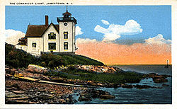 Conanicut Island Light in early twentieth century

Location: Jamestown, Rhode Island Coordinates: 41°34′24″N 71°22′21″W / 41.57333°N 71.3725°WCoordinates: 41°34′24″N 71°22′21″W / 41.57333°N 71.3725°W Built: 1886 Architect: Unknown Architectural style: Late Gothic Revival Governing body: Private MPS: Lighthouses of Rhode Island TR NRHP Reference#: 87001698[1] Added to NRHP: February 25, 1988 Conanicut Island Light (Conanicut Island Lighthouse), built in 1886, was an active lighthouse in Rhode Island.
The light was built primarily to assist the ferry between Jamestown and Newport, Rhode Island. The lighthouse lies on the eastern side of Conanicut Island in the town of Jamestown, Rhode Island. The light was deactivated in 1933 and its lantern was removed. In 1934 it was sold as government surplus. The lighthouse is listed on the National Register of Historic Places.
References and links
- America's Atlantic Coast Lighthouses, Kenneth Kochel, Betken Publications; 2nd ed., 1996. ISBN 0-9640765-2-7
- Northeast Lights: Lighthouses and Lightships, Rhode Island to Cape May, New Jersey, Robert Bachand, Sea Sports Publications. 1989. ISBN 0-9616399-3-8
- "Conanicut Lighthouse, RI," George Worthylake, The Keeper's Log, Winter 2004.
- ^ "National Register Information System". National Register of Historic Places. National Park Service. 2007-01-23. http://nrhp.focus.nps.gov/natreg/docs/All_Data.html.

U.S. National Register of Historic Places Topics Lists by states Alabama • Alaska • Arizona • Arkansas • California • Colorado • Connecticut • Delaware • Florida • Georgia • Hawaii • Idaho • Illinois • Indiana • Iowa • Kansas • Kentucky • Louisiana • Maine • Maryland • Massachusetts • Michigan • Minnesota • Mississippi • Missouri • Montana • Nebraska • Nevada • New Hampshire • New Jersey • New Mexico • New York • North Carolina • North Dakota • Ohio • Oklahoma • Oregon • Pennsylvania • Rhode Island • South Carolina • South Dakota • Tennessee • Texas • Utah • Vermont • Virginia • Washington • West Virginia • Wisconsin • WyomingLists by territories Lists by associated states Other Categories:- Buildings and structures completed in 1886
- Lighthouses on the National Register of Historic Places in Rhode Island
- Lighthouses in Newport County, Rhode Island
- United States lighthouse stubs
- Rhode Island Registered Historic Place stubs


Wikimedia Foundation. 2010.