- Point Judith Light
Infobox Lighthouse
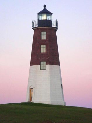
caption = Point Judith Light, Rhode Island, shown at sunset
location =Narragansett, Rhode Island
coordinates = coord|41|21|39.7|N|71|28|53|W|region:US_type:landmark
yearlit = 1857
automated = 1954
yeardeactivated = Active
foundation = Granite blocks
construction = Brownstone
shape = Octagonal conical
height = 51 feet
lens = Fourth orderFresnel lens
range =
characteristic = Infobox_nrhp | name =Point Judith Lighthouse
nrhp_type =
caption =
location=Narragansett, Rhode Island
lat_degrees = 41
lat_minutes = 21
lat_seconds = 39
lat_direction = N
long_degrees = 71
long_minutes = 28
long_seconds = 55
long_direction = W
locmapin = Rhode Island
area =
built =1857
architect= Unknown
architecture= No Style Listed
added =March 30 ,1988
governing_body = COAST GUARD
mpsub=Lighthouses of Rhode Island TR
refnum=88000279cite web|url=http://www.nr.nps.gov/|title=National Register Information System|date=2007-01-23|work=National Register of Historic Places|publisher=National Park Service] The Point Judith Light is located on the west side of the entrance toNarragansett Bay ,Rhode Island as well as the north side of the eastern entrance toBlock Island Sound. The confluence of two waterways make this area busy with water traffic and the waters aroundPoint Judith are very cold and dangerous. Historically, even with active lighthouses, there have been many shipwrecks off these coasts.Three light structures have been built on this site. The original 35-foot tower, built in 1810, was destroyed by a
hurricane in 1815. It was replaced in 1816, by a 35-foot stone tower with a revolving light and ten lamps. The presentoctagonal granite tower was built in 1856. It is 51 feet high which, with the height of its land foundation, places the focal point of the lens 65 feet abovesea level . The upper half of the tower is painted brown and the lower half white to make the light structure a more effective daymark for maritime traffic. In 1871, ship captains asked that Point Judith's fog signal be changed from a horn to whistle. This change distinguished the Point Judith light from theBeavertail Lighthouse , which used a siren to announce fog. A whistle could also be heard more distinctly over the sounds of the surf in the area. Point Judith Light was automated in 1954.References
* Crompton, Samuel Willard. "The Lighthouse Book." Barnes and Noble Books, New York, 1999. ISBN 0-7607-1135-6.
External links
* [http://www.cr.nps.gov/maritime/light/ptjudith.htm NPS - Historic light stations - Point Judith Light]
Wikimedia Foundation. 2010.