- Chinook Point
-
Chinook Point
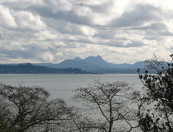
 View from Fort Columbia across the mouth of the Columbia River to Astoria, Oregon, and Saddle Mountain.
Nearest city: Chinook, Washington Built: 1792 Governing body: State NRHP Reference#: 66000747 Significant dates Added to NRHP: October 15, 1966[1] Designated NHL: July 4, 1961[2] Chinook Point is a headland in Pacific County, Washington. Captain Robert Gray, the first non-native to enter the Columbia River, saw the river from Chinook Point in 1792. His explorations gave the United States a strong position in its later territorial contests with Great Britain.[3]
In November 1805, members of the Lewis and Clark Expedition camped at Chinook Point.
It was the site of US military gun emplacements during World War II.[4]
It was declared a National Historic Landmark in 1961.[2][4]
It is now part or all of Fort Columbia State Park, which is in turn part of Lewis and Clark National and State Historical Parks.
It is located at U.S. Route 101 and State Route 12.[4]
References
- ^ "National Register Information System". National Register of Historic Places. National Park Service. 2007-01-23. http://nrhp.focus.nps.gov/natreg/docs/All_Data.html.
- ^ a b "Chinook Point". National Historic Landmark summary listing. National Park Service. http://tps.cr.nps.gov/nhl/detail.cfm?ResourceId=560&ResourceType=Site. Retrieved 2008-03-01.
- ^ Brokenshire 1993, p. 47
- ^ a b c Cecil McKithan (October 10, 1977). National Register of Historic Places Inventory-Nomination: Chinook PointPDF (32 KB). National Park Service. and Accompanying six photos, from 1977.PDF (32 KB)
External links
- Lewis and Clark National Park .COM
- U.S. Geological Survey Geographic Names Information System: Chinook Point
U.S. National Register of Historic Places Topics Lists by states Alabama • Alaska • Arizona • Arkansas • California • Colorado • Connecticut • Delaware • Florida • Georgia • Hawaii • Idaho • Illinois • Indiana • Iowa • Kansas • Kentucky • Louisiana • Maine • Maryland • Massachusetts • Michigan • Minnesota • Mississippi • Missouri • Montana • Nebraska • Nevada • New Hampshire • New Jersey • New Mexico • New York • North Carolina • North Dakota • Ohio • Oklahoma • Oregon • Pennsylvania • Rhode Island • South Carolina • South Dakota • Tennessee • Texas • Utah • Vermont • Virginia • Washington • West Virginia • Wisconsin • WyomingLists by territories Lists by associated states Other Coordinates: 46°15′5″N 123°55′19″W / 46.25139°N 123.92194°W
Categories:- National Historic Landmarks in Washington (state)
- Landforms of Pacific County, Washington
- Geography of Pacific County, Washington
- Headlands of Washington (state)
- Washington Registered Historic Place stubs
Wikimedia Foundation. 2010.
