- Ontario, Ohio
-
City of Ontario — City — Ontario Hellinger Municipal Building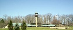 Location of Ontario, Ohio
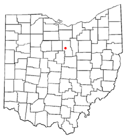
Coordinates: 40°46′8″N 82°36′11″W / 40.76889°N 82.60306°WCoordinates: 40°46′8″N 82°36′11″W / 40.76889°N 82.60306°W Country United States State Ohio County Richland Incorporated June 25, 1958 (village) - April 30, 2001 (city) Government – Mayor Larry Collins Area – Total 10.9 sq mi (28.3 km2) – Land 10.9 sq mi (28.3 km2) – Water 0.0 sq mi (0.0 km2) Elevation[1] 1,358 ft (414 m) Population (2000) – Total 5,303 – Density 485.7/sq mi (187.5/km2) Time zone Eastern (EST) (UTC-5) – Summer (DST) EDT (UTC-4) ZIP code 44862 Area code(s) 419 FIPS code 39-58520[2] GNIS feature ID 1057901[1] Website http://www.ontarioohio.org/ Ontario is a city in Richland County in the U.S. state of Ohio. It is part of the Mansfield, Ohio Metropolitan Statistical Area. The population was 5,303 at the 2000 census. Ontario is a major regional retail hub serving the entire North-Central Ohio area, with a shopping population of over 150,000.
Contents
History
The original town of Ontario started as a settlement in Springfield Township near Mansfield. In 1834, the Ontario settlement combined with another small settlement known as New Castle.
Ontario is located on a major east-west transportation corridor that was originally known in the early 1900s as "Ohio Market Route 3." This route was chosen in 1913 to become part of the historic Lincoln Highway which was the first road across America, connecting New York City to San Francisco. The arrival of the Lincoln Highway to Ontario was a major influence on the development of the town. Upon the advent of the federal numbered highway system in 1928, the Lincoln Highway through Ontario became U.S. Route 30.
In 1956, General Motors built a large Fisher Body stamping plant in Ontario and on June 25, 1958, the residents voted to incorporate Ontario into a village.[3]
In 1960, the new Ontario High School was built, complete with an indoor swimming pool, a theatre, 3 shops, and numerous high-tech classrooms and labs for college-preparatory studies. New school construction and renovation has continued over the years, and today the Ontario School District enjoys a long and distinguished reputation for education excellence with state-of-the-art facilities.
In 1969, the Richland Mall was built. It was the first modern enclosed mall in north-central Ohio, and was originally anchored by the prestigious Lazarus Department Store (based in Columbus), the O'Neil's Department Store (based in Akron), and by Sears. The Lazarus store was the first Lazarus built outside of Columbus. The store's unique "high-hat" entrance tower remains visible for miles along U.S. Route 30. The Lazarus store eventually became Macy's, and then subsequently was closed in 2006 following the purchase of the May Department Store company by Federated Department Stores, parent of Macy's and the former Lazarus. The mall in 2002 was renamed Westfield Shoppingtown Richland for a period of time, is once again called Richland Mall following a name change in 2006. It is now home to almost 70 stores and is anchored by Macy's (located in the original O'Neils store that had become Kaufmann's for a period of time), Sears, and JCPenney (a later addition to the mall).
The arrival of both General Motors and the Richland Mall to Ontario was the beginning of the eventual shift of commerce and industry from the adjacent rust belt city of Mansfield to the new suburb-satellite town of Ontario. On June 1, 2009, General Motors filed for Chapter 11 bankruptcy protection and announced that its Ontario stamping plant (Mansfield-Ontario Metal Center) will close in June 2010.[4][5][6] Several annexations have been made to Ontario since its incorporation and millions of dollars have been spent on public infrastructure including streets, water and sewer facilities, parks, schools, and new civic buildings for Administrative offices, Public Safety Departments and the Water Department. The city administration offices have been housed in several different locations including the "Old Library" which is now being used as a Senior Center. In 1986, the city's offices were moved to the newly constructed Charles K. Hellinger Municipal Building. On April 30, 2001, Ontario became a city with a population over 5,300.[7]
Since the 1960s, Ontario has been a location of choice for residential development, due in part to its civic administration, its school system, and significant commercial and industrial development.
Geography
Ontario is located at 40°46′08″N 82°36′11″W / 40.768906°N 82.603066°W (40.768906, -82.603066).[8]
According to the United States Census Bureau, the city has a total area of 10.9 square miles (28 km2), all of it land.
Demographics
Historical populations Census Pop. %± 1960 3,049 — 1970 4,345 42.5% 1980 4,123 −5.1% 1990 4,026 −2.4% 2000 5,303 31.7% 2010 6,225 17.4% source:[9] As of the census[2] of 2000, there were 5,303 people, 2,186 households, and 1,554 families residing in the city. The population density was 485.7 people per square mile (187.5/km2). The racial makeup of the city was 92.36% White, 4.11% African American, 0.04% Native American, 1.58% Asian, 0.04% Pacific Islander, 0.57% from other races, and 1.30% from two or more races. Hispanic or Latino of any race were 1.07% of the population.
There were 2,186 households out of which 32.1% had children under the age of 18 living with them, 58.8% were married couples living together, 9.7% had a female householder with no husband present, and 28.9% were non-families. 25.0% of all households were made up of individuals and 10.6% had someone living alone who was 65 years of age or older. The average household size was 2.43 and the average family size was 2.90.
In the city the population was spread out with 25.2% under the age of 18, 6.7% from 18 to 24, 28.0% from 25 to 44, 24.8% from 45 to 64, and 15.4% who were 65 years of age or older. The median age was 39 years. For every 100 females there were 95.0 males. For every 100 females age 18 and over, there were 88.4 males.
The median income for a household in the city was $46,146, and the median income for a family was $51,201. Males had a median income of $41,053 versus $26,250 for females. The per capita income for the city was $22,016. About 6.0% of families and 6.2% of the population were below the poverty line, including 11.6% of those under age 18 and 3.5% of those age 65 or over.
Education
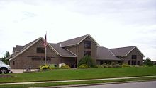 Mansfield/Richland County Public Library Ontario Branch
Ontario Public Schools enroll 1,820 students in public primary and secondary schools.[10] The district administers 4 public schools including one elementary school, one intermediate school, one middle school, and one high school.
Libraries
The Mansfield/Richland County Public Library operates a library branch in Ontario.[11]
Transportation
Ontario is connected by four major highways, U.S. Route 30 (the Lincoln Highway), which connects Mansfield and Interstate 71 to the east with Bucyrus to the west, State Route 309, which connects Mansfield to the east with Galion to the west, State Route 314, which connects Shelby to the north with Chesterville to the south, and State Route 430 (Park Avenue West) connecting Ontario to downtown Mansfield.[12]
Busy thoroughfares in Ontario are; Park Avenue West (State Route 430), West Fourth Street, Walker Lake Road, Home Road (along the eastern city limits at Mansfield), and Lexington-Springmill Road, which connects Springmill and State Route 39 to the north with Lexington to the south.[12]
Public safety
Law Enforcement - Ontario Police Department Fire & EMS - Springfield Township Fire Department
References
- ^ a b "US Board on Geographic Names". United States Geological Survey. 2007-10-25. http://geonames.usgs.gov. Retrieved 2008-01-31.
- ^ a b "American FactFinder". United States Census Bureau. http://factfinder.census.gov. Retrieved 2008-01-31.
- ^ "50th Anniversary Celebration Was a Grand Success!". City of Ontario. http://www.ontarioohio.org/50anniversary.htm. Retrieved 2008-12-01.
- ^ "General Motors files for bankruptcy protection". Mansfield News Journal. http://www.mansfieldnewsjournal.com/article/20090601/UPDATES01/90601015&referrer=FRONTPAGECAROUSEl. Retrieved 2009-06-03.[dead link]
- ^ "GM Writes off Ontario Plant". Mansfield News Journal. http://www.mansfieldnewsjournal.com/article/20090602/NEWS01/906020316&referrer=FRONTPAGECAROUSEL. Retrieved 2009-06-03.[dead link]
- ^ "Two Ohio cities, Parma and Ontario, react to news from General Motors". Cleveland.com. http://www.cleveland.com/business/index.ssf/2009/06/two_ohio_cities_parma_and_onta.html. Retrieved 2009-06-02.
- ^ "How Ontario Evolved". City of Ontario. http://www.ontarioohio.org/about.htm. Retrieved 2008-12-01.
- ^ "US Gazetteer files: 2010, 2000, and 1990". United States Census Bureau. 2011-02-12. http://www.census.gov/geo/www/gazetteer/gazette.html. Retrieved 2011-04-23.
- ^ "Census Of Population And Housing". U.S. Census Bureau. http://www.census.gov/prod/www/abs/decennial/index.htm. Retrieved 2011-04-26.
- ^ Great Schools.com. "Ontario Local School District Profile". http://www.greatschools.net/cgi-bin/oh/district_profile/548. Retrieved 2008-12-21.
- ^ "Ontario Branch". Mansfield/Richland County Public Library. http://www.mrcpl.org/branches/ontario-branch. Retrieved 2011-01-08.
- ^ a b "Map of Ontario, OH". Yahoo Maps. http://maps.yahoo.com/maps_result.php?q1=Ontario%2C+OH. Retrieved 2007-10-31.
External links
Municipalities and communities of Richland County, Ohio Cities 
Villages Townships Blooming Grove | Butler | Cass | Franklin | Jackson | Jefferson | Madison | Mifflin | Monroe | Perry | Plymouth | Sandusky | Sharon | Springfield | Troy | Washington | Weller | Worthington
Unincorporated
communitiesGhost towns Footnotes ‡This populated place also has portions in an adjacent county or counties
Categories:- Cities in Ohio
- Populated places in Richland County, Ohio
- Populated places established in 1834


Wikimedia Foundation. 2010.