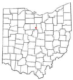
- Crestline, Ohio
-
Crestline, Ohio — Village — Location of Crestline, Ohio Coordinates: 40°47′5″N 82°44′25″W / 40.78472°N 82.74028°WCoordinates: 40°47′5″N 82°44′25″W / 40.78472°N 82.74028°W Country United States State Ohio Counties Crawford, Richland Founded 1851 Government – Mayor David Sharrock Area – Total 2.9 sq mi (7.5 km2) – Land 2.9 sq mi (7.5 km2) – Water 0.0 sq mi (0.0 km2) Elevation[1] 1,142 ft (348 m) Population (2000) – Total 5,088 – Density 1,761.8/sq mi (680.2/km2) Time zone Eastern (EST) (UTC-5) – Summer (DST) EDT (UTC-4) ZIP code 44827 Area code(s) 419 FIPS code 39-19330[2] GNIS feature ID 1061006[1] Website http://www.crestlineoh.com/ Crestline is a village in Crawford and Richland Counties in the U.S. state of Ohio. The population was 5,088 at the 2000 census. It is the third largest city in Crawford County. The Crawford County portion of Crestline is part of the Bucyrus Micropolitan Statistical Area, while the small portion of the city that extends into Richland County is considered part of the Mansfield Metropolitan Statistical Area.
Contents
History
During its heyday, Crestline was a division point for the Pennsylvania Railroad's Pittsburgh, Fort Wayne and Chicago Railway. The city housed major engine facilities and would often be the point where motive power was changed for the relatively flat runs to and from Chicago, Illinois. The Pennsylvania Railroad's engine facilities included a roundhouse, decommissioned in 1968 in the aftermath of the merger between the Pennsylvania Railroad and the New York Central Railroad to form Penn Central. Demolition of the historic roundhouse commenced in 2007 after years of neglect.[3] Today, Chicago, Fort Wayne and Eastern Railroad, CSX and Norfolk Southern trains operate in and around Crestline.[4]
Geography
Crestline is located at 40°47′5″N 82°44′25″W / 40.78472°N 82.74028°W (40.784657, -82.740192)[5], along the Sandusky River near its headwaters.
According to the United States Census Bureau, the city has a total area of 2.9 square miles (7.5 km²), all land.
Demographics
As of the census[2] of 2000, there were 5,088 people, 2,070 households, and 1,370 families residing in the city. The population density was 1,761.8 people per square mile (679.8/km²). There were 2,251 housing units at an average density of 779.5 per square mile (300.7/km²). The racial makeup of the city was 96.58% White, 1.81% African American, 0.18% Native American, 0.26% Asian, 0.06% Pacific Islander, 0.22% from other races, and 0.90% from two or more races. Hispanic or Latino of any race were 0.67% of the population.
There were 2,070 households out of which 33.3% had children under the age of 18 living with them, 48.9% were married couples living together, 12.6% had a female householder with no husband present, and 33.8% were non-families. 29.2% of all households were made up of individuals and 13.1% had someone living alone who was 65 years of age or older. The average household size was 2.44 and the average family size was 3.01.
In the city the population was spread out with 26.7% under the age of 18, 8.6% from 18 to 24, 29.1% from 25 to 44, 21.0% from 45 to 64, and 14.5% who were 65 years of age or older. The median age was 36 years. For every 100 females there were 92.1 males. For every 100 females age 18 and over, there were 87.9 males.
The median income for a household in the city was $31,392, and the median income for a family was $37,275. Males had a median income of $33,520 versus $22,455 for females. The per capita income for the city was $16,522. About 9.8% of families and 12.4% of the population were below the poverty line, including 16.5% of those under age 18 and 5.2% of those age 65 or over.
Government
Historical populations Census Pop. %± 1890 2,911 — 1900 3,282 12.7% 1910 3,807 16.0% 1920 4,313 13.3% 1930 4,425 2.6% 1940 4,337 −2.0% 1950 4,614 6.4% 1960 5,521 19.7% 1970 5,947 7.7% 1980 5,406 −9.1% 1990 4,934 −8.7% 2000 5,088 3.1% Est. 2008 4,882 −4.0% While the Census Bureau recognizes Crestline as a village,[2] its 2000 population of 5,088 makes it a city under Ohio law.[6]
Crestline operates under a mayor-council system, with a council of eight members. In 2008, the mayor was Joseph Polito, and City Council was composed of Jerry Bickert, Mike Blaising, Ken Frisby, Jerry Harbaugh (Council President), Clayton Herold, Ben Hocker, John Gledhill, and Robert Miller.[7]
See also
People from Crestline, Ohio
- Jack Ball, Sr. (1935–2009)
- Mike Gottfried (1945-)
- Gates Brown (1939-)
- Jack Harbaugh (1939-)
- Randy Price (1958-)
References
- ^ a b "US Board on Geographic Names". United States Geological Survey. 2007-10-25. http://geonames.usgs.gov. Retrieved 2008-01-31.
- ^ a b c "American FactFinder". United States Census Bureau. http://factfinder.census.gov. Retrieved 2008-01-31.
- ^ http://crestlineprr.com/
- ^ http://www.odotnet.net/map1/OhioRailMap/images/Ohio-Rail-Map-07-09-Fr-Lg.jpg
- ^ "US Gazetteer files: 2010, 2000, and 1990". United States Census Bureau. 2011-02-12. http://www.census.gov/geo/www/gazetteer/gazette.html. Retrieved 2011-04-23.
- ^ "Ohio Revised Code Section 703.01(A)". http://codes.ohio.gov/orc/703.01. Retrieved 2007-09-15.
- ^ City Officials, City of Crestline, 2008. Accessed 2009-07-27.
External links
Municipalities and communities of Crawford County, Ohio Cities Villages Chatfield | Crestline‡ | New Washington | North Robinson | Tiro
Townships Unincorporated
communitiesFootnotes ‡This populated place also has portions in an adjacent county or counties
Municipalities and communities of Richland County, Ohio Cities Villages Townships Blooming Grove | Butler | Cass | Franklin | Jackson | Jefferson | Madison | Mifflin | Monroe | Perry | Plymouth | Sandusky | Sharon | Springfield | Troy | Washington | Weller | Worthington
Unincorporated
communitiesGhost towns Footnotes ‡This populated place also has portions in an adjacent county or counties
Categories:- Cities in Ohio
- Populated places in Crawford County, Ohio
- Populated places in Richland County, Ohio
Wikimedia Foundation. 2010.


