- Ohio State Route 59
-
State Route 59
Route information Maintained by ODOT Length: 22.99 mi[1] (37.00 km) Existed: 1969 – present Major junctions West end: 
 I-76 / I-77 in Akron
East end:  SR 5 near Ravenna
Location Counties: Summit, Portage Highway system Ohio highways
Interstates • U.S. Routes • State Routes←  SR 58
SR 58SR 60  →
→State Route 59 (SR 59, OH 59) is an east–west state highway in the northeastern portion of Ohio, a U.S. state. The western terminus of State Route 59 is in downtown Akron at a partial interchange with the Interstate 76/Interstate 77 duplex. The eastern terminus of the state route is at State Route 5 just 0.5 miles (0.80 km) east of the Ravenna city limits.
Contents
Route description
State Route 59 traverses parts of Summit and Portage Counties. The portion of State Route 59 beginning at the northern interchange with the State Route 8 freeway, and heading east through Kent and Ravenna to the State Route 5 junction is included within the National Highway System, a network of routes deemed most important for the economy, mobility and defense of the nation.[2][3]
Haymaker Parkway
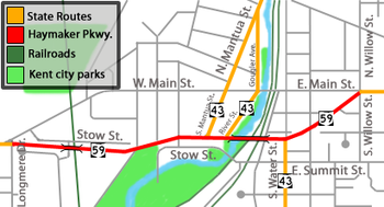 Map showing Haymaker Parkway in red.
Haymaker Parkway is the name given to the rerouted section of State Route 59 than runs through Kent, Ohio as a bypass road. It is a five-lane road with two bridges built between 1968 and 1975. The largest of the two bridges, the Redmond Greer Memorial Bridge, [1] passes over both sets of railroad tracks that pass through downtown Kent (known locally as the "upper" and "lower" tracks) as well as Franklin Avenue, the Cuyahoga River, and Franklin Mills Riveredge Park. The Greer bridge also carries SR 43 during its short co-sign with SR 59 in between South Mantua Street (SR 43 South) and River Street (SR 43 North), and South Water Street. The parkway's eastern terminus is at the intersection of East Main and Willow Streets and its western termninus is at the intersection of West Main Street and Longmere Drive. For much of its route it parallels (and actually bisects) Stow Street. It is named for the Haymaker family who, in December 1805, became the first family to settle Franklin Township and what would become Kent. The parkway was built mainly to provide bridges over all of Kent's railroad crossings for public safety vehicles as well as to relieve congestion in the downtown area. Several homes were razed in order to build the parkway, particularly many along Stow Street and in the neighborhood between Kent State University and downtown Kent along East Erie Street and East College Avenue.
History
State Route 59 was certified in 1969. The general route was originally designated as State Route 36 until 1932 and as State Route 5 from 1932 to 1969; however, State Route 5 now takes a turn south on an expressway southeast of Ravenna towards I-76 rather than heading west to Cuyahoga Falls and Akron. The route is a freeway in its shared portion with State Route 8 southward from Front Street in Cuyahoga Falls. State Route 59 is signposted as following Perkins Avenue westward from State Route 8, where, at Howard Street, it becomes the freeway officially known as the Martin Luther King Jr. Freeway, more commonly referred to as the Innerbelt. (Until August 17, 2007, this routing was identified in Ohio DOT records as State Route 59T, whereas State Route 59 in the records continued south along State Route 8 and ended at the Market Street/State Route 18 underpass.)[4] The rest of the route is formed by regular roads, with the exception of the Haymaker Parkway in Kent, which is a bypass with cross streets.
The section of the route that runs through Stow and Kent was widened sometime in the 1980s. The section in Cuyahoga Falls from the State Route 8 to near Victor St. was widened in 2004 to meet state requirements due to high traffic levels.
The prior alignment of State Route 59 is primarily followed by the current State Route 113.
The Innerbelt
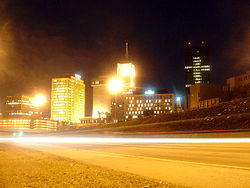 The Innerbelt looking northeast
The Innerbelt portion of State Route 59 in Akron is not well utilized. Designed after almost all other highway projects in Akron were completed, the Innerbelt was envisioned as a 21.5-mile (34.6 km) stretch; however the only portion that was ever built was a 2.24-mile (3.60 km) stretch near Akron’s downtown. The freeway is designed with 6 lanes (with right of way for eight), two collector streets along the entire corridor that combined are at some points as wide as the freeway itself, and very sweeping interchanges. The ramps connecting it to Interstate 76/Interstate 77, opened October 8, 1986, more than a decade after most of the rest of the highway opened,[5] only turn to the west, so traffic can only enter the Innerbelt if traveling east on the interstate and from the Innerbelt, vehicles can only exit west onto the interstate. While ODOT is currently evaluating changing this design,[6] for now drivers need to take regular roads to make the connection. This was a financial concession when the southernmost part of the Innerbelt was built. The connection to the Northern Freeway (State Route 8) was never made, and a temporary link with Martin Luther King Blvd./Perkins St. became permanent.
Shortly after the connection to Interstate 76/Interstate 77, it became clear that the Innerbelt would not live up to expectations; those not served by the western ramps were not very willing to travel over five blocks of marginal roads to connect to a 2.24-mile (3.60 km) freeway. However, the Innerbelt’s underuse has given it an advantage few planners had foreseen. In July, 2001, the city announced that the Innerbelt would be closed for several days while a commercial was being shot.[7] The highway was also surveyed by the producers of the movie Matrix Reloaded, as a possible shooting spot of the highway scene. Peter Novak, the Matrix's location scout said that "They were looking at finding a practical freeway to film the car chase on, which was going to be about 6 to 7 weeks of shutting down a major freeway. It was originally thought that they needed 4 to 5 miles of super highway in both directions. We sent scouts out around the world: we had people looking around Kuala Lumpur, people looking at Bangkok, people looking at the autobahn in Germany, and I personally looked through the northern United States. I don’t think we left a stone unturned, and we wound up with a freeway in Akron..."[8] The idea was eventually scrapped, because in the event that the scene would have to be reshot, the time to reset all the cars in their start position would take too long.[9]
Akron mayor Don Plusquellic has suggested ripping up the northern end of the freeway, making it a regular road, and developing the surrounding land. Akron cannot expand its borders anymore so the city government is looking into ways of bringing about new development inside the city limits. The idea was fostered by a trip to Milwaukee, in which Mayor Plusquellic saw the much-maligned Park East Freeway spur in that city's downtown removed in order to reuse the land. However, over $65,000,000 was spent to build the Innerbelt and according to current estimates $100,000,000 would have to be spent to demolish and reconstruct the corridor. A two million dollar study is currently underway at the request of city hall.
Major intersections
County Location Mile[1] Destinations Notes Summit Akron 0.00 I-76
I-77Western terminus at interchange with I-76/I-77. Going southbound, traffic defaults onto I-76/77 West. Traffic wishing to go eastbound must exit at SR 261. 1.07  SR 261
Junction with SR 261 (Wooster Ave./V. Odom Blvd./Opportunity Pkwy.). Traffic on SR 59 South must exit here to access I-76/77 eastbound. 2.50  SR 18
SR 18
 SR 162
Junction with SR 18/SR 162 concurrency (W. Market St.). 2.77 SR 261Junction with SR 261 westbound (N. High St. one-way). 2.83 SR 261Junction with SR 261 eastbound (N. Broadway St. one-way). 3.53  SR 8
SR 8Southern split of duplex with SR 8; SR 8 continues south. 4.73 SR 261Junction with SR 261 (Tallmadge Ave.). Cuyahoga Falls 8.16 SR 8Northern split of duplex with SR 8; SR 8 continues north. Stow 10.46  SR 91
SR 91Junction with SR 91 (Darrow Rd.). Portage Kent 14.50  SR 43
SR 43Western split of brief duplex with SR 43 over Haymaker Parkway bridge; SR 43 south enters from S. Mantua St. 14.81 SR 43Eastern split of duplex with SR 43; SR 43 continues south (S. Water St.). Franklin Township 16.78 SR 43Eastern terminus of SR 261. Ravenna 21.41  SR 88
SR 88Southern terminus of SR 88 (Freedom St.). Ravenna Township 22.17  SR 14
SR 14
 SR 44
SR 44Junction with SR 44/SR 14 duplex. 22.99 SR 5Eastern terminus. Highway continues as SR 5. 1.000 mi = 1.609 km; 1.000 km = 0.621 mi State Route 261 intersects with State Route 59 in total, four times: on the east side of Kent, at Tallmadge Avenue during its co-sign with State Route 8 in Akron, at Martin Luther King Jr. Boulevard near the Y-Bridge, and at Opportunity Parkway on the Innerbelt.
References
- ^ a b Ohio Department of Transportation. "Technical Services Straight Line Diagrams". http://www.odotonline.org/techservapps/SLD/default.htm. Retrieved 2010-04-30.
- ^ Federal Highway Administration (December 2003) (PDF). National Highway System: Ohio (Map). http://www.fhwa.dot.gov/planning/nhs/maps/oh/oh_Ohio.pdf. Retrieved 2010-09-15.
- ^ Federal Highway Administration (December 2003) (PDF). National Highway System: Akron, Ohio (Map). http://www.fhwa.dot.gov/planning/nhs/maps/oh/akron_oh.pdf. Retrieved 2010-09-15.
- ^ "Straight-Line Diagrams County Update Table (Summit, 2008)". Ohio Department of Transportation.
- ^ "Only One More Innerbelt Link to Go", Akron Beacon Journal, October 9, 1986.
- ^ Central Interchange, Design alternative currently under evaluation by ODOT
- ^ COMMERCIAL SHOOT TO CLOSE INNERBELT THIS WEEK, Mark Williamson 2001 (retrieved January 30, 2005)
- ^ KEY LOCATION MANAGER, USA, Peter Novak 2001 (retrieved November 19, 2005)
- ^ Chasing the Stars: Carmakers in Movies, Ann Job (retrieved January 30, 2005)
External links
- State Route 59 Endpoint Photos
- Akron Innerbelt; Martin Luther King Jr. Freeway (Photographs of the Innerbelt)
Categories:- State highways in Ohio
- Transportation in Akron, Ohio
- Kent, Ohio
- Transportation in Portage County, Ohio
- Transportation in Summit County, Ohio


Wikimedia Foundation. 2010.