- Chester, Connecticut
-
Chester, Connecticut — Town — 
SealLocation within Middlesex County, Connecticut
Coordinates: 41°24′08″N 72°28′57″W / 41.40222°N 72.4825°WCoordinates: 41°24′08″N 72°28′57″W / 41.40222°N 72.4825°W Country United States State Connecticut NECTA New Haven Region Connecticut River Estuary Incorporated 1836 Government - Type Selectman-town meeting - First selectman Thomas E. Marsh Area - Total 16.8 sq mi (43.5 km2) - Land 16.0 sq mi (41.5 km2) - Water 0.8 sq mi (2.1 km2) Elevation 361 ft (110 m) Population (2005) - Total 3,832 - Density 240/sq mi (92/km2) Time zone EST (UTC-5) - Summer (DST) EDT (UTC-4) ZIP code 06412 Area code(s) 860 FIPS code 09-14300 GNIS feature ID 0213407 Website http://www.chesterct.com/ Chester is a town in Middlesex County, Connecticut, United States. The population was 3,743 at the 2000 census. The town center is also defined by the U.S. Census Bureau as a census-designated place (CDP).
Contents
Geography
According to the United States Census Bureau, the town has a total area of 16.8 square miles (44 km2), of which, 16.0 square miles (41 km2) of it is land and 0.8 square miles (2.1 km2) of it (4.75%) is water. The CDP has a total area of 2.1 square miles (5.4 km2) of which 1.46% is water.
Demographics
As of the census[1] of 2000, there were 3,743 people, 1,510 households, and 1,005 families residing in the town. The population density was 233.5 people per square mile (90.2/km²). There were 1,613 housing units at an average density of 100.6 per square mile (38.9/km²). The racial makeup of the town was 96.79% White, 0.85% African American, 0.35% Native American, 0.83% Asian, 0.05% Pacific Islander, 0.24% from other races, and 0.88% from two or more races. Hispanic or Latino of any race were 1.71% of the population.
 Memorial Day ceremony in Chester, 1990
There were 1,510 households out of which 29.7% had children under the age of 18 living with them, 56.9% were married couples living together, 7.0% had a female householder with no husband present, and 33.4% were non-families. 28.1% of all households were made up of individuals and 13.0% had someone living alone who was 65 years of age or older. The average household size was 2.38 and the average family size was 2.93.
In the town the population was spread out with 22.3% under the age of 18, 4.4% from 18 to 24, 30.1% from 25 to 44, 26.1% from 45 to 64, and 17.2% who were 65 years of age or older. The median age was 42 years. For every 100 females there were 91.6 males. For every 100 females age 18 and over, there were 91.6 males.
The median income for a household in the town was $65,156, and the median income for a family was $79,941. Males had a median income of $45,515 versus $40,444 for females. The per capita income for the town was $32,191. None of the families and 1.3% of the population were living below the poverty line, including no under eighteens and 2.6% of those over 64.
CDP
As of the census of 2000, there were 1,546 people, 632 households, and 401 families residing in the CDP. The population density was 762.1 inhabitants per square mile (294.0/km²). There were 669 housing units at an average density of 329.8 per square mile (127.2/km²). The racial makeup of the CDP was 96.31% White, 1.29% African American, 0.06% Native American, 1.36% Asian, 0.06% from other races, and 0.91% from two or more races. Hispanic or Latino of any race were 1.29% of the population.
There were 632 households out of which 30.4% had children under the age of 18 living with them, 53.8% were married couples living together, 6.6% had a female householder with no husband present, and 36.4% were non-families. 30.5% of all households were made up of individuals and 10.1% had someone living alone who was 65 years of age or older. The average household size was 2.32 and the average family size was 2.91.
In the CDP the population was spread out with 21.9% under the age of 18, 4.9% from 18 to 24, 31.8% from 25 to 44, 26.1% from 45 to 64, and 15.4% who were 65 years of age or older. The median age was 41 years. For every 100 females there were 93.0 males. For every 100 females age 18 and over, there were 94.8 males.
The median income for a household in the CDP was $64,236, and the median income for a family was $71,250. Males had a median income of $38,900 versus $46,354 for females. The per capita income for the CDP was $32,087. None of the families and 0.5% of the population were living below the poverty line, including no under eighteens and none of those over 64.
Voter Registration and Party Enrollment as of October 25, 2005[2] Party Active Voters Inactive Voters Total Voters Percentage Democratic 810 50 860 31.30% Republican 570 39 609 22.16% Unaffiliated 1,137 136 1,273 46.32% Minor Parties 6 0 6 0.21% Total 2,523 225 2,748 100% Education
Chester, like the other two towns in the "tri-town area" (Essex and Deep River), is a member of Regional School District #4. John Winthrop Junior High School and Valley Regional High School, which are both on Warsaw Street in Deep River, serve students for grades 7-8 and 9-12, respectively.
Media
The 1959 film It Happened to Jane was filmed in Chester. Portions of the 1971 film Let's Scare Jessica to Death were filmed in Chester.
Points of interest
- The Beth Shalom Rodfe Zedek synagogue is noted for the architecture of its "spectacular" building.[3]
- The Chester Museum at the Mill, a future museum of the Chester Historical Society
- The Chester–Hadlyme Ferry is the second oldest continuously operating ferry service in the state of Connecticut and is a designated state historical landmark.
On the National Registered Historic Places
- Charles Daniels House — 43 Liberty St. (added March 19, 1988)
- Dr. Ambrose Pratt House — Pratt St. (added December 9, 1972)
- Jonathan Warner House — 47 Kings Hwy. (added 1978)
- Old Town Hall — On the green between Liberty St. and Goose Hill Rd. (added March 23, 1972)
- Villa Bella Vista — 7 Old Depot Rd. (added 2000)
Transportation
Air
The Chester Airport is a privatedly owned local facility with one paved runway.
Ground
The Estuary Transit District provides public transportation throughout Chester and the surrounding towns through its 9 Town Transit Service. Services include connections to the Old Saybrook Train Station, served by Amtrak and Shoreline East railroads.
Notable residents, past and present
- Art Carney (1918–2003), actor was a resident and died in town.
- Paul Hopkins (1904–2004), major league relief pitcher was born in town.
- Sol LeWitt (1928–2007), artist.
- Richard Sachs (1953-), bicycle framebuilder and cyclist lives in town.
- Morley Safer (1931-), CBS news correspondent and anchor on "60 Minutes"[4]
- Max Showalter (1917–2000), film and television actor retired to Chester.
- Washington F. Willcox (1834–1909), US Congressman was a resident.
Pictures of Chester
-
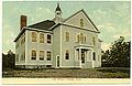
Chester High School, circa 1906-1916
-

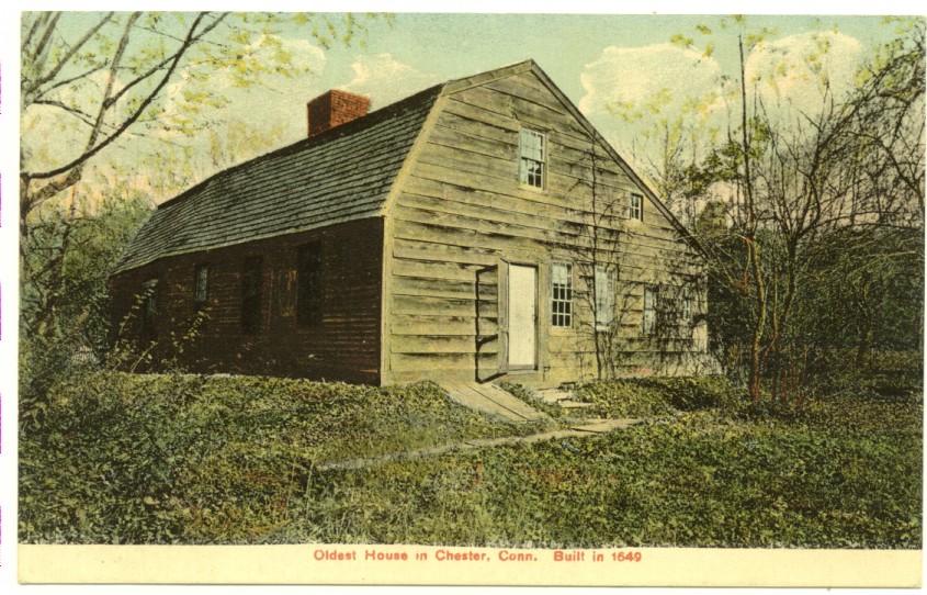
Oldest house in Chester, built 1649 (picture circa 1906-1916)
-
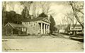
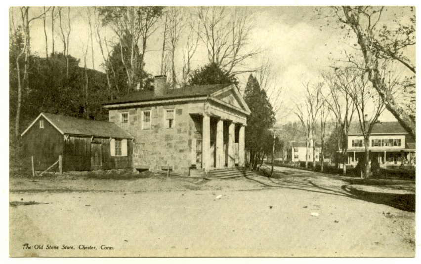
Old Stone Store, circa 1901-1907
-
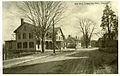
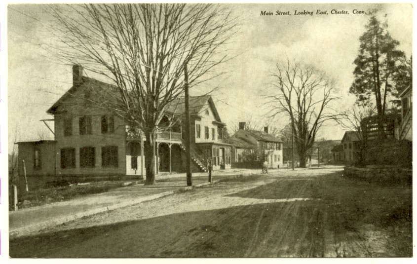
Main Street, looking east, circa 1901-1907
References
- ^ "American FactFinder". United States Census Bureau. http://factfinder.census.gov. Retrieved 2008-01-31.
- ^ "Registration and Party Enrollment Statistics as of October 25, 2005" (PDF). Connecticut Secretary of State. Archived from the original on 2006-09-23. http://web.archive.org/web/20060923151511/http://www.sots.ct.gov/ElectionsServices/lists/2005OctRegEnrollStats.pdf. Retrieved 2006-10-02.
- ^ Columbia Daily Spectator, April 10, 2007 , Small-town Artist With a Big-time Legacy by Ginia Sweeney [1]
- ^ Maker, Elizabeth, "Suddenly, Balls in Every Court", The New York Times, June 1, 2003, retrieved January 27, 2010
External links
- Town government Web site
- Town of Chester Official GIS Maps and Property Information
- Central Regional Tourism District
 State of Connecticut
Topics - Index
- Culture
- Constitution
- Delegations
- Elections
- Geography
- Government
- History
- Images
- People
- Visitor Attractions
Regions Counties Cities Places Municipalities and communities of Middlesex County, Connecticut City 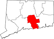
Towns Chester | Clinton | Cromwell | Deep River | Durham | East Haddam | East Hampton | Essex | Haddam | Killingworth | Middlefield | Old Saybrook | Portland | Westbrook
Borough Unincorporated
communitiesCenterbrook | Essex Village | Higganum | Ivoryton | Lake Pocotopaug | Leesville | Middle Haddam | Millington | Moodus | Saybrook Manor
Categories:- Chester, Connecticut
- Towns in Middlesex County, Connecticut
- Populated places on the Connecticut River


Wikimedia Foundation. 2010.