- Corwin, Tippecanoe County, Indiana
-
Corwin — Unincorporated area — The grain elevators at Corwin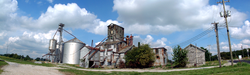 Location within the state of Indiana
 Corwin
Coordinates: 40°15′5″N 86°54′52″W / 40.25139°N 86.91444°WCoordinates: 40°15′5″N 86°54′52″W / 40.25139°N 86.91444°W Country United States State Indiana County Tippecanoe Township Randolph Time zone Eastern (EST) (UTC-5) - Summer (DST) EDT (UTC-4) ZIP codes FIPS code GNIS feature ID Corwin was a small town, now extinct, in Tippecanoe County in the U.S. state of Indiana. It was laid out by Cyrus Foltz in 1856 and consisted of seven lots near the rail line which ran south out of Lafayette. The town never flourished, though, and was eclipsed by nearby Romney.[1]
Later maps sometimes cite the town as Corwin Station.[2]
Geography
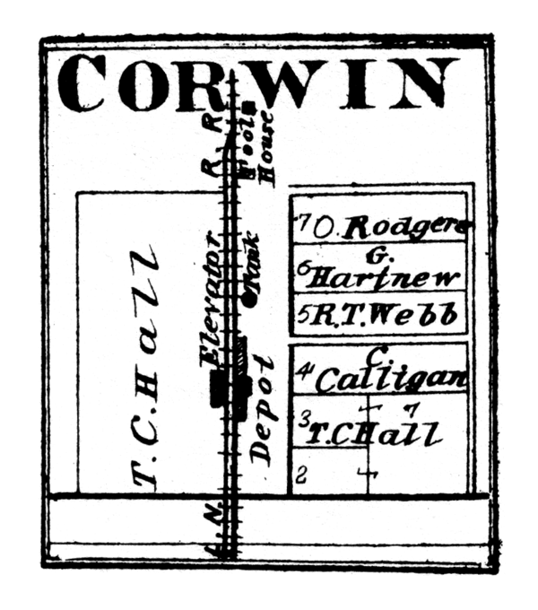
 Corwin in 1878.
Corwin is located at 40°15'5" North, 86°54'52" West (40.251426, -86.914397) at an elevation of approximately 740 feet. It sits in Randolph Township half a mile west of the town of Romney and is on a north/south CSX rail line.
References
- ^ "Ghost Towns of Tippecanoe County". http://www.ingenweb.org/intippecanoe/ghosttowns.htm. Retrieved 2008-11-15.
- ^ Indiana Historical Society. Maps of Indiana Counties in 1876. 1968. (Reprinted from Illustrated Historical Atlas of the State of Indiana. Chicago: Baskin, Forster & Company, 1876.)
Municipalities and communities of Tippecanoe County, Indiana County seat: Lafayette Cities 
Towns Battle Ground | Clarks Hill | Dayton | Otterbein‡ | Shadeland
Townships Unincorporated
communitiesAmericus | Ash Grove | Buck Creek | Cairo | Colburn | Concord | Monitor | Monroe | Montmorenci | North Crane | Odell | Pettit | Romney | South Raub | Stockwell | Westpoint
Ghost towns Footnotes ‡This populated place also has portions in an adjacent county or counties
Categories:- Ghost towns in Indiana
- Geography of Tippecanoe County, Indiana
- Indiana geography stubs
- United States ghost town stubs


Wikimedia Foundation. 2010.