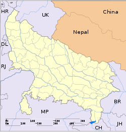
- Chakia, Uttar Pradesh
-
For other places with the same name, see Chakia (disambiguation).
Chakia — city — Coordinates 25°03′N 83°13′E / 25.05°N 83.22°ECoordinates: 25°03′N 83°13′E / 25.05°N 83.22°E Country India State Uttar Pradesh District(s) Chandauli Population 13,667 (2001[update]) Time zone IST (UTC+05:30) Area
• 78 metres (256 ft)
Chakia is a town and a nagar panchayat in Chandauli district in the Indian state of Uttar Pradesh.
Contents
Geography
Chakia is located at 25°03′N 83°13′E / 25.05°N 83.22°E.[1] It has an average elevation of 78 metres (255 feet). It is surrounded by beauty of Nature. The famous Vindhya mountain series starts from here.
Education
In spite of being a small town, chakia has good Schools & colleges. Aditya Narayan Government Intermedite College is the prestigious college in District.It was established in 1952 by Kaashi Naresh. Maharani jayanti kunwari kanya inter college,which was also established by Kaash Naresh in year 1996, is spreading knowledge among girls and providing good platform for future. Chakia also boasts of having S.B.F. Govt. P.G. college. Bapu Bal Vidya Mandir, Bharat Mata Vidya Mandir, Saraswati Shishu MandirShanti niketan junier high school takiya shah bhola utaraut,adarsh vidya mandir utaraut and others are good schools in town. Iqra Model School has started English medium education in town. But Silver Bells Academy and International English School are now leading in Convent Education. Govt also runs several Primary schools and Junior High Schools in town.
Business
In this time chakia has good market. there are 43 village which is dependent on this market.now chakia is a developed town. Rohit general stores & pradeep garments providing chakia the best market and A.K.Tent House Utraut Is Also A good Service For Marriage And Birth Day Parties.its a best shop which is developing the market of chakia
Chakia has a big hospital with 500beds in it. which is providing the people better treatment. there are also manidir kali mandir, pokhra, nirbhay das, hanuman mandir, chandraprbha vanya jeev bihar, musakhar daim, latif sah daragah, raja ka kila, rashidi chaw
medical faicility-anil ausdhalay,gov hospital, keshari medico, Patel Medical (Sheesh Narayan Patel) forest-chanraprbha rengh, rajpath reng, chakiya renj. marketly-rohit genral store, harsha gorment, pradip vastralay,
chakiya police-100 ambulence-107 firebigred-101
Demographics
As of 2001[update] India census,[2] Chakia had a population of 13,667. Males constitute 52% of the population and females 48%. Chakia has an average literacy rate of 59%, lower than the national average of 59.5%; with male literacy of 68% and female literacy of 50%. 18% of the population is under 6 years of age.
References
- ^ Falling Rain Genomics, Inc - Chakia
- ^ "Census of India 2001: Data from the 2001 Census, including cities, villages and towns (Provisional)". Census Commission of India. Archived from the original on 2004-06-16. http://web.archive.org/web/20040616075334/http://www.censusindia.net/results/town.php?stad=A&state5=999. Retrieved 2008-11-01.
Categories:- Cities and towns in Chandauli district
- Uttar Pradesh geography stubs
Wikimedia Foundation. 2010.


