- New York State Route 481
-
NYS Route 481
Veterans Memorial Highway 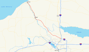
Map of the Syracuse area with NY 481 highlighted in redRoute information Maintained by NYSDOT and the cities of Fulton and Oswego Length: 31.79 mi[2] (51.16 km) Existed: January 1, 1970[1] – present Major junctions South end: 
 I-81 / I-481 in North Syracuse
 NY 31 in Clay
 NY 3 in Fulton
North end:  NY 104 in Oswego
Location Counties: Onondaga, Oswego Highway system Numbered highways in New York
Interstate • U.S. • N.Y. (former) • Reference • County← I-481NY 488  →
→New York State Route 481 (NY 481) is a state highway in Central New York in the United States. The southern terminus of the route is at an interchange with Interstate 81 (I-81) in North Syracuse, where the highway continues southeastward as I-481. Its northern terminus is located at an intersection with NY 104 in Oswego about two blocks from Lake Ontario. In between, NY 481 serves the communities of Clay, Phoenix and Fulton along the Oswego River. NY 481 is one of two state routes in the Syracuse area that serves as an extension of an Interstate Highway; the other is NY 690.
From its southern terminus to the Fulton city line, NY 481 is a four-lane limited-access highway with a handful of interchanges. It enters Fulton as a four-lane undivided highway, but gradually narrows to two lanes as it heads through the northern portion of the city. North of Fulton, NY 481 becomes a four-lane divided highway and proceeds to the outskirts of Oswego, where it reverts back into a two-lane roadway. NY 481 also serves as a faster alternate to NY 48 from the Syracuse area to downtown Oswego. Both travel along the Oswego River, with NY 481 on the eastern side and NY 48 on the western side.
NY 481 was commissioned in 1970 from North Syracuse to Fulton and extended northward to Oswego in 1982. The portion of the route north of Fulton was designated as NY 20 from 1924 to 1927 and NY 57 from 1927 to 1982. The segment of NY 481 south of Fulton follows a newer facility that was built in the 1970s.
Contents
Route description
NY 481 begins in North Syracuse at I-81 (running north to Watertown and south to Syracuse) and I-481 (continuing east in a loop around Syracuse). This is about a mile to the north of Syracuse Hancock International Airport. NY 481 begins as an extension of I-481 as it is a four-lane expressway with a handful of interchanges for about the first 20 miles (32 km) of its run. NY 481 crosses U.S. Route 11 (US 11) almost immediately, passing just south of the former site of Penn-Can Mall. NY 481 then enters the town of Clay, where it meets NY 31 in the center of a large area of retail shopping, including several strip malls and the Great Northern Mall.[3]
NY 481 continues northward, mostly through farmland, crossing the Oneida River and the Erie Canal at the boundary between Oswego and Onondaga counties. Just across the county line, NY 481 has an exit for NY 264 about a mile north of Phoenix in rural Schroeppel. The junction with NY 264 is the last interchange on the route. However, NY 481 remains limited-access up to the Fulton city line, where it intersects County Route 57 (CR 57) at-grade.[3] The first 0.28 miles of NY 481 in the city of Fulton starting at the south city line is maintained by the city.
In Fulton, NY 481 travels slowly through the center of town along several predominantly two-lane city streets, and constitutes the main north–south route through that town. Bridges across the Oswego River may be seen to the west when the road crosses Broadway and Oneida Street. North of the city, NY 481 expands to a four-lane divided highway once more.[3]
The portion of NY 481 from Fulton to Oswego closely parallels the Oswego River and contains several stretches of scenic beauty, mostly consisting of glimpses of locks, rapids and small waterfalls through trees along the river. The views are slightly better coming from the north, since the waterfalls are more evident when coming from downstream. Here it closely parallels NY 48, which it is only separated from by the river itself.[3]
NY 481 enters Oswego and becomes the two-lane East River Road, passing by a large post-modern structure which is the Oswego County Public Safety Center (housing County offices, courts, and a Correctional Facility). As NY 481 approaches its northern terminus at NY 104, bridges across the Oswego River can be seen to the west at Bridge Street and Utica Street. East First Street, which NY 481 becomes upon entering downtown and becomes city maintained, continues north past NY 104 to Oswego Harbor on the shores of Lake Ontario.[3]
Official designations
By New York state statute, Route 481, as well as its continuation, Interstate 481, comprise the Veterans Memorial Highway.[4] A sign on the northbound side of Route 481 near its southernmost point announces this. However, a sign on the southbound side of the highway, just after it leaves Fulton, erroneously announces that the highway is the Disabled American Veterans Memorial Highway. The same statute indicates that this is the designation of "that portion of United States route twenty beginning at the community of Irving, where route five and route twenty merge with Old Lake Shore road, and continuing northeasterly until approximately one mile south of the town of Depew, Erie county, then continuing easterly across New York state to its terminus at the New York-Massachusetts border approximately two miles east of the town of New Lebanon, Columbia county." This highway never intersects any part of the Veterans Memorial Highway, though it does come within eight miles (13 km) of it at one point. The erroneous sign lies approximately 40 miles (64 km) north of that point.
Alternate routes
A route combining NY 48 and NY 690 also travels between Oswego, Fulton and Syracuse, but along the western side of the Oswego River. Although shorter in distance, this route travels through more built-up areas and is significantly slowed by reduced speed limits. This route is therefore more commonly used for trips from Oswego to Baldwinsville or other points to the west of Syracuse.
History
The primary north–south roadway connecting Syracuse to Oswego via Fulton on the eastern bank of the Oswego River was originally designated as Route 34, an unsigned legislative route, by the New York State Legislature in 1908.[5][6] When the first set of posted routes in New York were assigned in 1924, legislative Route 34 was designated as NY 20.[7][8] NY 20 was redesignated as NY 57 in 1927 to avoid numerical duplication with the newly designated U.S. Route 20.[9] The NY 57 corridor remained unchanged until the late 1950s when construction began on a new roadway to replace the existing two-lane, curvy routing of NY 57 between Fulton and Oswego. It was completed by 1960.[10][11]
In the mid-1960s, construction began on a limited-access highway linking Fulton to I-81 in North Syracuse.[12][13] The under-construction highway, initially known as "Relocated Route 57", was designated as NY 481 on January 1, 1970. The NY 481 designation also extended north to NY 3 in Fulton by way of a short overlap with NY 57.[1] The portion of the expressway between Fulton and NY 31 in Clay was opened to traffic in the early 1970s[14][15] while the rest was completed ca. 1973.[15][16] NY 481 was extended northward to its present terminus in downtown Oswego when the NY 57 designation was eliminated in May 1982.[17]
Major intersections
The segment of NY 481 between North Syracuse and Fulton is a limited-access highway. Exit numbers continue from I-481.
County Location Mile[2] Exit Destinations Notes Onondaga North Syracuse 0.00 I-481Continuation beyond I-81 9N-S I-81 – Syracuse, Watertown0.50 10  US 11 – North Syracuse
Access to US 11 via Bear Road and Circle Drive Clay 11 Caughdenoy Road / Maple Road Northbound exit only 6.97 12 NY 31 – Baldwinsville, CiceroOneida River Oswego Schroeppel 10.54 13 Phoenix (CR 57A) Northbound exit and southbound entrance 13.04 14  NY 264 – Phoenix, Mexico
Begin at-grade intersections northbound and limited-access highway southbound Fulton 19.49  CR 57
CR 57Former routing of NY 57 20.62 NY 3Oswego 31.79 NY 1041.000 mi = 1.609 km; 1.000 km = 0.621 mi See also
- Interstate 481 for exits 1 through 8
References
- ^ a b State of New York Department of Transportation (January 1, 1970) (PDF). Official Description of Touring Routes in New York State. http://www.greaternyroads.info/pdfs/state70.pdf. Retrieved May 11, 2010.
- ^ a b "2008 Traffic Data Report for New York State" (PDF). New York State Department of Transportation. June 16, 2009. p. 318. https://www.nysdot.gov/divisions/engineering/technical-services/hds-respository/NYSDOT_Traffic_Data_Report_2008.pdf. Retrieved January 10, 2010.
- ^ a b c d e Google, Inc. Google Maps – overview map of NY 481 (Map). Cartography by Google, Inc. http://maps.google.com/maps?f=d&hl=en&geocode=13919006129996969147,43.457512,-76.507661%3B17401592425938012143,43.141698,-76.115370&saddr=RT-481+%4043.457512,+-76.507661&daddr=43.141454,-76.113539&mra=dme&mrcr=0&mrsp=1&sz=14&sll=43.141454,-76.124268&sspn=0.028308,0.057936&ie=UTF8&ll=43.31119,-76.272583&spn=0.451665,0.926971&z=10. Retrieved February 24, 2008.
- ^ "New York State Highway Law § 342-v**". http://caselaw.lp.findlaw.com/nycodes/c50/a14.html. Retrieved October 4, 2006.
- ^ State of New York Department of Highways (1909). The Highway Law. Albany, New York: J. B. Lyon Company. p. 64. http://books.google.com/books?id=jZ0AAAAAMAAJ&pg=PA64. Retrieved May 11, 2010.
- ^ New York State Department of Highways (1920). Report of the State Commissioner of Highways. Albany, New York: J. B. Lyon Company. p. 548. http://books.google.com/books?id=Sj4CAAAAYAAJ&pg=PA548. Retrieved May 11, 2010.
- ^ "New York's Main Highways Designated by Numbers". The New York Times: p. XX9. December 21, 1924.
- ^ Rand McNally and Company (1926). Rand McNally Auto Road Atlas (western New York) (Map). http://www.broermapsonline.org/members/NorthAmerica/UnitedStates/Midatlantic/NewYork/unitedstates1926ra_008.html. Retrieved May 11, 2010.
- ^ Automobile Blue Book. 1 (1927 ed.). Chicago: Automobile Blue Book, Inc. 1927. This edition shows U.S. Routes as they were first officially signed in 1927.
- ^ Esso (1958). New York with Special Maps of Putnam–Rockland–Westchester Counties and Finger Lakes Region (Map). Cartography by General Drafting (1958 ed.).
- ^ Gulf (1960). New York and New Jersey Tourgide Map (Map). Cartography by Rand McNally and Company.
- ^ Mobil (1965). New York (Map). Cartography by Rand McNally and Company.
- ^ Esso (1968). New York (Map). Cartography by General Drafting (1969–70 ed.).
- ^ Sun Oil Company (1969). New York and Metropolitan New York City (Map). Cartography by Diversified Map Corporation (1969–70 ed.).
- ^ a b Gulf (1972). New York and New Jersey Tourgide Map (Map). Cartography by Rand McNally and Company (1972 ed.).
- ^ Shell Oil Company (1973). New York (Map). Cartography by H.M. Gousha Company (1973 ed.).
- ^ New York State Department of Transportation (January 2009) (PDF). Official Description of Highway Touring Routes, Bicycling Touring Routes, Scenic Byways, & Commemorative/Memorial Designations in New York State. https://www.nysdot.gov/divisions/operating/oom/transportation-systems/repository/2009%20tour-bk.pdf. Retrieved July 16, 2009.
External links
Categories:- State highways in New York
- Limited-access roads in New York
- Transportation in Onondaga County, New York
- Transportation in Oswego County, New York


Wikimedia Foundation. 2010.