- New York State Route 488
-
NYS Route 488
Route information Maintained by NYSDOT Length: 9.53 mi[3] (15.34 km) Existed: ca. 1973[1][2] – present Major junctions South end:  NY 21 in Hopewell
North end:  NY 96 in Phelps
Location Counties: Ontario Highway system Numbered highways in New York
Interstate • U.S. • N.Y. (former) • Reference • County←  NY 481
I-490  →
→New York State Route 488 (NY 488) is a state highway in Ontario County, New York, in the United States. It extends for 9.53 miles (15.34 km) from an intersection with NY 21 in the town of Hopewell, near the city of Canandaigua, to a junction with NY 96 midway between the villages of Phelps and Clifton Springs. NY 488 also passes through the hamlet of Orleans, located within the town of Phelps. Although NY 488 is signed as a north–south highway, most of the route follows an east–west alignment. NY 488 was originally designated as part of NY 88 in the 1930 renumbering of state highways in New York. NY 88 was truncated to the village of Phelps ca. 1973, at which time its former routing between NY 21 and NY 96 was renumbered to NY 488.
Contents
Route description
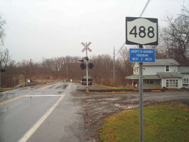
 NY 488 heading eastbound from its western terminus in Chapin. The Finger Lakes Railway is visible in the distance
NY 488 begins at an intersection with NY 21 in the hamlet of Chapin, a small community within the Ontario County town of Hopewell. The highway progresses eastward, crossing the Finger Lakes Railway at a grade crossing less than 100 yards (91 m) from NY 21. Just past the railroad, the route makes a slight turn to the northeast for 0.25 miles (0.40 km) before curving back to the east and continuing across open farmland. As NY 488 crosses the town of Hopewell, it serves a handful of isolated homes and intersects several north–south highways of local importance, including County Road 47 (CR 47). The route continues eastward into the town of Phelps, where it serves a pair of large farms on its way to the small hamlet of Orleans,[4] located on both the western bank of Flint Creek and the right-of-way of the now-defunct Pennsylvania Railroad (PRR).[5]
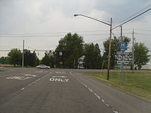 NY 488 approaching its eastern terminus in Phelps. The traffic light is NY 96
In the western portion of Orleans, NY 488 intersects with the north–south CR 20, which leads to most of the hamlet's residences. NY 488, meanwhile, bypasses most of the community to the northwest as it makes a gradual turn to the north to follow Flint Creek[4] and the old PRR right-of-way[5] toward the village of Phelps. Outside of Orleans, the route reenters mostly rural surroundings as it approaches a junction with CR 43. While CR 43 heads north toward Clifton Springs, NY 488 turns to the northeast, following the creek and the old rail bed past the large reservoir serving the village of Newark. At an intersection with Trimble and Griffith Roads, the highway turns back to the north, matching a similar curve in the creek's routing.[4] NY 488 continues on, crossing the former right-of-way of the Lehigh Valley Railroad and passing Midlakes High School on an otherwise nondescript stretch before ending at an intersection with NY 96 west of the village of Phelps.[4][5]
History
On May 25, 1915, the state of New York let a contract to improve an 8.63-mile (13.89 km) highway connecting the city of Canandaigua to the hamlet of Orleans to state highway standards. The reconstruction of the highway was 70 percent complete by 1920[6] and finished by 1926, by which time the highway was added to the state highway system[7] as State Highway 1278 (SH 1278).[6] The north–south highway connecting Orleans to the village of Phelps was rebuilt to state highway standards ca. 1930[8][9] as SH 1863.[10] In the 1930 renumbering of state highways in New York, SH 1278 and SH 1863 became part of the new NY 88, which began in the village of Sodus and extended southward through Phelps to the intersection of West Avenue and Main Street in Canandaigua.[11][12] NY 88 was truncated on its southern end to Phelps ca. 1973. Its former routing from NY 21 in the hamlet of Chapin to NY 96 west of Phelps was renumbered to NY 488.[1][2]
Major intersections
The entire route is in Ontario County.
Location Mile[3] Destinations Notes Hopewell 0.00 NY 21Hamlet of Chapin Town of Phelps 9.53 NY 961.000 mi = 1.609 km; 1.000 km = 0.621 mi References
- ^ a b Gulf Oil Company (1972). New York and New Jersey Tourgide Map (Map). Cartography by Rand McNally and Company (1972 ed.).
- ^ a b Shell Oil Company (1973). New York (Map). Cartography by H.M. Gousha Company (1973 ed.).
- ^ a b "2008 Traffic Data Report for New York State" (PDF). New York State Department of Transportation. June 16, 2009. p. 318. https://www.nysdot.gov/divisions/engineering/technical-services/hds-respository/NYSDOT_Traffic_Data_Report_2008.pdf. Retrieved January 10, 2010.
- ^ a b c d Microsoft. Map of NY 488 – Bing Maps (Map). Cartography by NavTEQ, Inc. http://www.bing.com/maps/?v=2&cp=42.9387778928084~-77.16493785381317&lvl=13&dir=0&sty=b&rtp=pos.42.91852342126383_-77.23476633729553_near%20Schutt%20Rd%2C%20Canandaigua%2C%20NY%2014424___a_~pos.42.96176048277666_-77.09609600736128_near%20State%20Route%2096%20%26%20State%20Route%20488%2C%20Phelps%2C%20NY%2014532___a_&mode=D&rtop=0~0~0~. Retrieved December 14, 2010.
- ^ a b c United States Geological Survey (1953). Phelps Quadrangle – New York – Ontario Co. (Map). 1:24,000. 7.5 Minute Series (Topographic). http://www.nysgis.state.ny.us/gisdata/quads/drg24/usgspreview/index.cfm?code=o42077h1. Retrieved December 14, 2010.
- ^ a b New York State Department of Highways (1920). Report of the State Commissioner of Highways. Albany, New York: J. B. Lyon Company. pp. 262, 418. http://books.google.com/books?id=Sj4CAAAAYAAJ&pg=PA262. Retrieved December 14, 2010.
- ^ State of New York Department of Public Works (1926). Official Map Showing State Highways and other important roads (Map). Cartography by Rand McNally and Company.
- ^ Standard Oil Company of New York (1929). New York in Soconyland (Map). Cartography by General Drafting.
- ^ Standard Oil Company of New York (1930). Road Map of New York (Map). Cartography by General Drafting.
- ^ New York State Department of Transportation (2000). Phelps Digital Raster Quadrangle (Map). 1:24,000. http://www.nysgis.state.ny.us/gisdata/quads/drg24/dotpreview/index.cfm?code=q22. Retrieved December 14, 2010.
- ^ State of New York Department of Transportation (January 1, 1970) (PDF). Official Description of Touring Routes in New York State. http://www.greaternyroads.info/pdfs/state70.pdf. Retrieved June 17, 2009.
- ^ Automobile Legal Association (ALA) Automobile Green Book, 1930–31 and 1931–32 editions, (Scarborough Motor Guide Co., Boston, 1930 and 1931). The 1930–31 edition shows New York state routes prior to the 1930 renumbering
External links
Categories:- State highways in New York
- Transportation in Ontario County, New York

Wikimedia Foundation. 2010.