- New York State Route 57
-
NYS Route 57
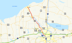
Map of the Syracuse area with NY 57 highlighted in redRoute information Maintained by NYSDOT Length: 33.45 mi[3][4] (53.83 km) Existed: 1927[1] – May 1982[2] Major junctions South end:  US 11 in Syracuse
 I-90 / Thruway in Liverpool
 NY 31 near Baldwinsville

 NY 3 / NY 176 in Fulton
North end:  NY 104 in Oswego
Location Counties: Onondaga, Oswego Highway system Numbered highways in New York
Interstate • U.S. • N.Y. (former) • Reference • County←  NY 56A
NY 58  →
→New York State Route 57 (NY 57) was a major north–south state highway in Central New York, connecting downtown Syracuse to the Lake Ontario shoreline in Oswego. The southern terminus of the route was at U.S. Route 11 in Syracuse just north of downtown and a short distance east of Lake Onondaga's southeastern tip. The northern terminus was at NY 104 (previously U.S. Route 104) six blocks from Lake Ontario in Oswego. In between, NY 57 passed through Phoenix and Fulton and bypassed Baldwinsville.
North of Liverpool, NY 57 was routed along the eastern bank of the Seneca and Oswego Rivers. The route was paralleled by NY 48, which followed (and still follows) the western bank of the waterway between Van Buren and Oswego.
NY 57 became part of the state highway system in 1924 as New York State Route 20. The route was renumbered to NY 57 three years later and remained virtually unchanged for the remainder of its existence. In later years, NY 57 was replaced in purpose by NY 481 south of Fulton, which led to its complete removal in 1982. The county routes that replaced NY 57 south of Fulton still bear the number 57 on signage in both counties, even though the portion of former NY 57 in Onondaga County is officially designated as CR 91.
Contents
Route description
NY 57 began at the intersection of Park Street and Wolf Street (U.S. Route 11) north of downtown Syracuse and adjacent to the southeastern edge of Onondaga Lake. The route headed northwest on Park Street, passing through a large interchange on Interstate 81 before reaching a smaller interchange with Buckley Road and Old Liverpool Road. NY 57 continued northwest through the interchange, becoming Onondaga Lake Parkway and paralleling both the northeastern edge of Onondaga Lake and the now-CSX Transportation-owned St. Lawrence Subdivision toward Liverpool. Midway up the length of the lake, NY 57 split from the lakeshore and became Oswego Street as it entered Liverpool. Here, NY 57 met the then-eastern terminus of NY 370 and interchanged with the New York State Thruway (Interstate 90) before leaving the Syracuse area.
Shortly after intersecting John Glenn Boulevard, a local arterial, north of Liverpool, NY 57 took on a more pronounced northwesterly routing, matching the path of the Seneca River a short distance to the west and the CSX Fulton Subdivision to the east. In Clay, east of Baldwinsville, NY 57, now primarily a residential roadway, intersected NY 31 shortly before crossing the Oneida River and entering Oswego County.
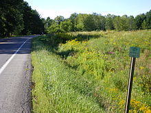 Old reference marker on NY 57's former routing north of Phoenix
Now in the town of Schroeppel, NY 57 progressed northward in the shadow of the Oswego River, the product of the convergence of the Seneca and Oneida Rivers. The route passed through Phoenix, meeting the southern terminus of NY 264, prior to intersecting NY 481 south of Fulton. At the time, NY 481 joined NY 57 northward into Fulton on 4th and 2nd Streets before terminating at Broadway (NY 3 and NY 176). NY 57 continued onward on 2nd Street, following the Oswego River and NY 48, routed on the opposite bank, out of the city.
Between Fulton and Oswego, the land surrounding NY 57 was predominantly rural in nature, with few points of interest along the alignment. North of Fulton, NY 57 passed near the Battle Island State Park, located off of NY 48 on the west bank of the river. In Seneca Hill, across the river from Minetto midway between the two cities, NY 57 met County Route 45, a local roadway leading to the Minetto Bridge, the only crossing of the Oswego River between Oswego and Fulton.
South of Oswego, NY 57 merged with an older alignment of the roadway and became East River Road (in contrast to NY 48, named West River Road) as it entered the city. At Albany Street, East River Road became East 1st Street, a name the route retained to its terminus at NY 104, once U.S. Route 104, in downtown Oswego. Although NY 57 ended here, East 1st Street continued northward for a short distance to the Port of Oswego on Lake Ontario.
History
The primary north–south roadway connecting Syracuse to Oswego via Fulton on the eastern bank of the Oswego River was originally designated as Route 34, an unsigned legislative route, by the New York State Legislature in 1908.[5][6] When the first set of posted routes in New York were assigned in 1924, legislative Route 34 was designated as NY 20.[7][8] NY 20 was redesignated as NY 57 in 1927 to eliminate numerical duplication with the newly designated U.S. Route 20.[1] The NY 57 corridor remained unchanged until the late 1950s when construction began on a new roadway to replace the existing two-lane, curvy routing of NY 57 between Fulton and Oswego. It was completed by 1960.[9][10]
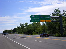 Overhead sign with a NY 57 shield instead of a County Route 57 shield on former NY 57 southbound near Liverpool
In the mid-1960s, construction began on a limited-access highway linking Fulton to Interstate 81 in North Syracuse.[11][12] The under-construction highway, initially known as "Relocated Route 57", was designated as NY 481 on January 1, 1970. The NY 481 designation also extended north to NY 3 in Fulton by way of a short overlap with NY 57.[13] The expressway was completed in the early 1970s, largely replacing NY 57 as the primary roadway between Fulton and Syracuse.[14][15] NY 57 and NY 481 continued to coexist until May 1982, when the NY 57 designation was eliminated.[2] All of former NY 57 north of Fulton became part of an extended NY 481 while the portion of NY 57's former alignment east of Liverpool became an extension of NY 370.[16][17] The short piece of former NY 57 in Liverpool between Tulip Street and NY 370 became NY 931G, an unsigned reference route.[2]
The remainder of former NY 57 between Tulip Street in Liverpool and NY 481 south of Fulton was turned over to Oswego and Onondaga Counties and became county routes. In Oswego County, the old alignment of NY 57 south of Fulton became the signed County Route 57 (CR 57). In Onondaga County, the former routing of NY 57 was designated as CR 91; however, it is signed as CR 57 in homage to the state route that preceded it.[18] Many reference markers for NY 57 are still intact along its former routing from Liverpool to Fulton. CR 57 continues to serve as a major thoroughfare today, serving the various rural communities on the route.
Major intersections
County Location Mile[3][4] Destinations Notes Onondaga Syracuse 0.00 US 111.02  I-81
I-81Exit 23 (I-81) Liverpool 3.10  NY 370
Eastern terminus of NY 370 4.02 I-90 / ThruwayExit 38 (I-90 / Thruway) Clay 9.59 NY 31Oswego Phoenix 13.73  NY 264
Southern terminus of NY 264 Fulton 21.15  NY 481 south
Southern terminus of NY 57 / NY 481 overlap 22.28 NY 3 / NY 176 / NY 481Northern terminus of NY 57 / NY 481 overlap; northern terminus of NY 481 Oswego 33.45 NY 1041.000 mi = 1.609 km; 1.000 km = 0.621 mi References
- ^ a b Automobile Blue Book. 1 (1927 ed.). Chicago: Automobile Blue Book, Inc. 1927. This edition shows U.S. Routes as they were first officially signed in 1927.
- ^ a b c New York State Department of Transportation (January 2009) (PDF). Official Description of Highway Touring Routes, Bicycling Touring Routes, Scenic Byways, & Commemorative/Memorial Designations in New York State. https://www.nysdot.gov/divisions/operating/oom/transportation-systems/repository/2009%20tour-bk.pdf. Retrieved May 13, 2010.
- ^ a b Yahoo! Inc. Yahoo! Maps – mileage of former NY 57 south of NY 481 (Map). Cartography by NAVTEQ. http://maps.yahoo.com/#mvt=m&lat=43.136251&lon=-76.306888&zoom=12&q1=43.071046%2C-76.164422&q2=43.079886%2C-76.179829&q3=43.102518%2C-76.204672&q4=43.114001%2C-76.212589&q5=43.180302%2C-76.261255&q6=43.231087%2C-76.30018&q7=43.30738%2C-76.396181. Retrieved May 13, 2010.
- ^ a b "2008 Traffic Volume Report for New York State" (PDF). New York State Department of Transportation. June 16, 2009. p. 238. https://www.nysdot.gov/divisions/engineering/technical-services/hds-respository/NYSDOT%20TVR%202008%20by%20Route.pdf. Retrieved May 13, 2010.
- ^ State of New York Department of Highways (1909). The Highway Law. Albany, New York: J. B. Lyon Company. p. 64. http://books.google.com/books?id=jZ0AAAAAMAAJ&pg=PA64. Retrieved May 11, 2010.
- ^ New York State Department of Highways (1920). Report of the State Commissioner of Highways. Albany, New York: J. B. Lyon Company. p. 548. http://books.google.com/books?id=Sj4CAAAAYAAJ&pg=PA548. Retrieved May 11, 2010.
- ^ "New York's Main Highways Designated by Numbers". The New York Times: p. XX9. December 21, 1924.
- ^ Rand McNally and Company (1926). Rand McNally Auto Road Atlas (western New York) (Map). http://www.broermapsonline.org/members/NorthAmerica/UnitedStates/Midatlantic/NewYork/unitedstates1926ra_008.html. Retrieved May 11, 2010.
- ^ Esso (1958). New York with Special Maps of Putnam–Rockland–Westchester Counties and Finger Lakes Region (Map). Cartography by General Drafting (1958 ed.).
- ^ Gulf (1960). New York and New Jersey Tourgide Map (Map). Cartography by Rand McNally and Company.
- ^ Mobil (1965). New York (Map). Cartography by Rand McNally and Company.
- ^ Esso (1968). New York (Map). Cartography by General Drafting (1969–70 ed.).
- ^ State of New York Department of Transportation (January 1, 1970) (PDF). Official Description of Touring Routes in New York State. http://www.greaternyroads.info/pdfs/state70.pdf. Retrieved May 11, 2010.
- ^ Sun Oil Company (1969). New York and Metropolitan New York City (Map). Cartography by Diversified Map Corporation (1969–70 ed.).
- ^ Shell Oil Company (1973). New York (Map). Cartography by H.M. Gousha Company (1973 ed.).
- ^ State of New York (1981). I Love New York Tourism Map (Map). Cartography by Rand McNally and Company.
- ^ Rand McNally and Company (1985). New York (Map). ISBN 0-528-91040-X.
- ^ New York State Department of Transportation (1989). Baldwinsville Digital Raster Quadrangle (Map). 1:24,000. http://www.nysgis.state.ny.us/gisdata/quads/drg24/dotpreview/index.cfm?code=o28. Retrieved May 13, 2010.
External links
Categories:- Former state highways in New York
- Transportation in Onondaga County, New York
- Transportation in Oswego County, New York
- Transportation in Syracuse, New York


Wikimedia Foundation. 2010.