- Mount Lawley, Western Australia
-
Mount Lawley
Perth, Western Australia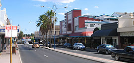
Beaufort Street, Mount Lawley.
 Mount Lawley
Population: 10,001 (2006 census)[1] Established: 1900s Postcode: 6050 Area: 4.0 km² (1.5 sq mi) Location: 4 km (2 mi) NE of Perth LGA: State District: Perth, Mount Lawley Federal Division: Perth Suburbs around Mount Lawley: Menora Bayswater Inglewood North Perth Mount Lawley Maylands Perth Highgate East Perth Coordinates: 31°56′04″S 115°52′20″E / 31.9345°S 115.8722°E
Mount Lawley is an inner suburb of Perth, Western Australia. Most of the suburb lies within the Local Government Area of the City of Stirling and small portions are in the City of Vincent and City of Bayswater. In 2006, the Town of Vincent applied to the Local Government Advisory Board to absorb all of Mount Lawley into its boundaries but this was ultimately rejected.
Mount Lawley was named in honour of Sir Arthur Lawley, the Governor of Western Australia from May 1901 to August 1902. His wife, Lady Annie Lawley, agreed to the naming of what was then bushland in her husband's name on the condition that no licensed hotels be built in the suburb.[2]
The south-eastern corner borders the Swan River, the southern boundary stretches through to Hyde Park, and the west and northern boundaries are Fitzgerald Street and Central Avenue.
Contents
Character
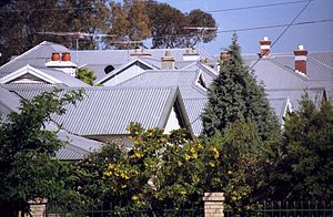 Mount Lawley rooftops
Although it is reducing, Mount Lawley still has a fair number of properties with quarter acre blocks (1,011 m²) which was the common subdivision size for most of the suburb's existence. This has been maintained by strict zoning regulations imposed by the City of Stirling in which a special "Mount Lawley Heritage Protection Area" management plan has been implemented. The plan sets much of the suburb as R-20 Zoning and defines permissible building standards such as set-backs and boundary easements.[3] The Heritage Protection Area plan was developed in recognition of the large stock of original "Federation", Art Deco and California Bungalow homes which have been generally well maintained or restored. The 'Mount Lawley Society'[4] actively lobbies the council and residents to maintain and enforce the standards.
There is a historical ambience to many streets – although contemporary homes and multi-dwelling subdivisions such as units are becoming more common.
Facilities
Although primarily residential, the suburb has a diverse range of shopping facilities, cafes and restaurants situated mainly along Beaufort Street close to the Walcott Street intersection. There are two primary schools, two secondary schools, adult education facilities as well as private hospitals and aged care facilities.
Sporting facilities and lifestyle attractions for residents include a trendy cafe strip centred on Beaufort and Walcott Streets with many restaurants,, a well known bookshop and video/DVD hire and sale outlet (Planet Video/Planet Books), and the Astor Cinema, which has been converted to a theatre and shows a mixture of music and comedy acts, as well as art film|art house films. The Mount Lawley Bowling Club is the only sporting club with permanent premises in the suburb, but Perth Soccer Club has clubrooms for their juniors at Forrest Park.
Transport
Public transport
Mount Lawley is well positioned to take advantage of public transit in Perth. The Mount Lawley train station is situated to the east of the suburb, and provides access to Midland in the north and then Perth in the south. There are also a number of bus routes which service the area.
Approximately 13% of Mount Lawley residents use public transport to travel to work.[1]
Road infrastructure
The majority of the Mount Lawley road network is laid out in the regular grid pattern, which was the popular method at the time of subdivision. There is a small area east of Beaufort Street, which has more curved streets that follow the contour of the land.
The main collector roads in Mount Lawley are Beaufort Street running North-South, leading into Morley in the north, and heading directly towards Perth city in the south. Walcott Street is another collector road, running East-West dissecting Mount Lawley and North Perth, leading commuters towards a main arterial, Wanneroo Road. Guildford Road and Railway Parade are two important arterial roads that provide service to the Graham Farmer Freeway, Tonkin Highway and the Great Eastern Highway. They run South-West - North-East, and terminate in East Perth in the south, while providing a service to Midland and Guildford in the north.
Demographics
The median individual income for Mount Lawley residents in 2006 was $630 per week, while the median family income was $1842 per week. The median age of Mount Lawley residents was 36 years.[1]
Mount Lawley is predominantly a white collar suburb. In 2006 managers, professionals and clerical & administrative workers comprised 64% of the work force in Mount Lawley.[1]
61% of Mount Lawley residents were Australian born. The next largest country of birth was the United Kingdom at 9%, followed by Italy at 4%.[1]
42% of families in Mount Lawley were a couple household with no children, while 43% of families were a couple with children (living at home).[1]
Education
Mount Lawley hosts a campus of Edith Cowan University as well as the Western Australian Academy of Performing Arts.
The suburb is home to Mount Lawley Senior High School (MLSHS), a state school which opened in 1955 which was extensively renovated with $40 million of Government funding in 2005-06.
In addition to MLSHS, the suburb hosts the Anglican girls school Perth College, a private K-12 campus for both day and boarding students.
References
- ^ a b c d e f Australian Bureau of Statistics (25 October 2007). "Mount Lawley (State Suburb)". 2006 Census QuickStats. http://www.censusdata.abs.gov.au/ABSNavigation/prenav/LocationSearch?collection=Census&period=2006&areacode=SSC51981&producttype=QuickStats&breadcrumb=PL&action=401. Retrieved 2008-10-05.
- ^ "Captain Sir Arthur Lawley 1901-1902". The Constitutional Centre of Western Australia. http://www.ccentre.wa.gov.au/index.cfm?event=governorsArthurlawley. Retrieved 2006-11-27.
- ^ City of Stirling Heritage Protection Areas Design guidelines Note: R-20 permits a minimum individual lot size of 540 m2
- ^ Mount Lawley society web page
Suburbs of the City of Stirling | Perth | Western Australia Coastal Carine · Churchlands · Doubleview · Gwelup · Innaloo · Karrinyup · North Beach · Scarborough · Trigg · Watermans Bay · Wembley Downs¹ · Woodlands

Central Balcatta · Balga · Dianella · Glendalough · Hamersley · Herdsman · Joondanna · Mirrabooka · Nollamara · Osborne Park · Stirling · Tuart Hill · Westminster · Yokine
South Eastern ¹ Suburb shared with other Local Government Areas Suburbs of the City of Vincent | Perth | Western Australia East Perth · Highgate · Leederville · Mount Hawthorn · Mount Lawley · North Perth · Perth · West Perth
Suburbs of the City of Bayswater | Perth | Western Australia Categories:- Suburbs of Perth, Western Australia


Wikimedia Foundation. 2010.