- Gwelup, Western Australia
Infobox Australian Place | type = suburb
name = Gwelup
city = Perth
state = wa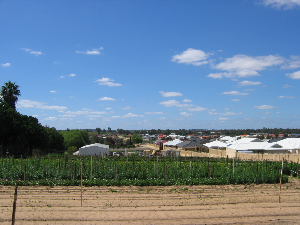
caption = A market garden on North Beach Road, surrounded by residential development.
lga = City of Stirling
area = 2.9
postcode= 6018
pop = 3,239 (2006 census)Census 2006 AUS|id=SSC51566|name=Gwelup (State Suburb)|quick=on|accessdate=2008-10-05]
dist1 = 12 | location1=Perth
est = 1970s
fedgov = Stirling
stategov= Carine
near-nw = Carine
near-n = Carine
near-ne = Hamersley
near-w = Karrinyup
near-e = Balcatta
near-sw = Doubleview
near-s = Innaloo
near-se = Stirlingcoord|-31.8762|115.7989|type:city(3239)_region:AU-WA_scale:30000|format=dms|display=titleGwelup is a suburb of Perth, the capital city of
Western Australia , and is located 12 km north of Perth'scentral business district (CBD) along theMitchell Freeway . Its Local Government Area is theCity of Stirling .History and Environment
The name "Gwelup" refers to a small swamp located within the southern portion of the suburb. It was derived from the
Noongar word "Gwelgannow" meaning "to shift position". Hence, Lake Gwelup was referred to as "thelake that shifts position". The name first appears in Lands Department records in 1878 as "Gwelup Swamp". [LandInfo WA|m|G|2007-05-15]Situated on the western side of the suburb of Gwelup, lies the remainder of the once broader Lake Gwelup and accompanying bushland nature reserve. As one of the few wetlands that has a mostly intact native bushland, Lake Gwelup is home to a wide variety of local and visitor birds (waders, raptors, ducks etc) as well many frog, reptile species (eg. dugites, skinks and long necked turtles). Native flora in the bushland include Marri (Corymbia), Jarrah (Eucolyptus marginata), Flooded Gum (E. rudis), Tuart (E. gomophcephela) as well as at least four species of Banksia, many annual wildflowers (incl. orchids) and fungi. One of the most spectacular species of visiting birds is the Rainbow Bee Eater.
Throughout the wetland regions, aboriginals hunted for kangaroo, emu, snakes, tortoise, mudfish, gilgies and water birds and their eggs, to name a few food sources. Aboriginal sites are known to have existed in a few locations in the Gwelup-Balcatta region.cite web|url=http://home.vicnet.net.au/~folg/history/history.htm|title=A Brief History of Gwelup|accessdate=2006-09-27|author=Friends of Lake Gwelup]
Land near Lake Gwelup was first granted to Thomas Mews in 1831. It passed through several owners before being acquired by
Henry Bull ofSydney in 1891. Gwelup was subdivided by Henry Bull during 1898 and 1899; however, development was relatively slow and the land was used mainly formarket garden s in the early years. In the 1960s, the area which presently accommodates The Willows Estate also offered a 6 hectare peat deposit which was mined for local agriculture. ["North Suburban Supplement", "The West Australian", 20 July 1961, accessed at Battye Library, Perth.] From the 1970s, Gwelup transformed from a rural area to a modern residential suburb. Only a fewmarket garden s along North Beach Road remain as a reminder of earlier times.cite web|url=http://www.stirling.wa.gov.au/home/council/Suburbs/Gwelup.htm|title=Suburbs - Gwelup|accessdate=2006-09-15|author=City of Stirling] TheMitchell Freeway 's extension to Erindale Road in 1984 and to Ocean Reef Road in 1986-87 facilitated the area's development.The triangle bounded by Lake Gwelup, Porter Street and North Beach Road is the oldest residential section, having been opened up by the Metropolitan Region Planning Authority in 1967 for urban development [Gazette WA | title = Metropolitan Region Scheme - Notice | page = 1967:1631 | date = 17 May 1967] - other parts were built and settled in the late 1990s when the swamps were drained. Controversy has arisen as to the effect of both the draining and of some building practices on the groundwater in the catchment region. ["Stirling Times", various editions, 2004 and 2006]
Geography and Hydrography
Gwelup is bounded by Lake Gwelup, the
Mitchell Freeway to the east, Old Balcatta Road to the north (Reid Highway , accessible via Duffy Road, is located just a few hundred metres further north) and Karrinyup Road to the south. Due to Gwelup's swampy nature and the Lake Gwelup Reserve, considerable tracts of land remain undeveloped. Peaty soils around the lake region that have been reclaimed, now feature the highest concentrations of dissolved arsenic in the world - some 25000ug/L (some 400 times higher than that identified as safe levels for drinking water). It is well known among scientific communities that disturbance of acid sulphate soils causes the release of As, iron sulfides and other chemicals.Streetsmart WA|maps=Map 311] . In the previous 32 years prior to 2000, the lake was recorded to dry out once twice, since that year the lake barely remained wet once over the summer in 2005/2006. The lowered water tables can be blamed on reduced rainfall and overconsumption of regional scheme waters.At the ABS 2006 census, Gwelup had a mostly white middle-income population of 3,239 people living in 1,102 dwellings. The type and style of residential dwellings contained within Gwelup varies considerably, ranging from early
market garden cottages to recently designed two-storey developments. New subdivisions, including Karrinyup Waters, Settlers Green and The Willows, contain modern architecturally designed homes. Along North Beach Road, there are remnants of older, rural-style housing. These character homes are gradually being renovated or replaced by new developments.Facilities
Gwelup is a residential suburb, with the Gwelup Plaza neighbourhood shopping centre which meets daily shopping needs. Nearby Karrinyup Shopping Centre provides other services. The suburb contains [http://www.lakegwelup.wa.edu.au/ Lake Gwelup Primary School] , originally opened in 1914 in two wooden school buildings which are now heritage-listed, [cite web|url=http://www2.eddept.wa.edu.au/schoolprofile/home.do|title=Lake Gwelup Primary School (School Overview)|author=Education Department of WA|accessdate=2006-11-18] and Gwelup falls within
Carine Senior High School 's catchment area.Gwelup has significant areas of public open space scattered throughout the residential area, offering meeting places and recreational opportunities for the local and wider community. Lake Gwelup, a convert|75|ha|acre|0|sing=on reserve vested in the City of Stirling and centred on the 25 hectare Lake Gwelup Wetland, preserves a significant part of the natural environment, while allowing passive recreation. There are also tennis courts and
cycle path s located on theLake Gwelup Reserve.Careniup Swamp, the wetland which gave its name to nearby Karrinyup, was formerly bounded by Gribble Road, Balcatta Road, North Beach Road and the freeway. Much of it was drained for housing in the mid-1990s, but the northwestern section of it has been preserved as a wetland and recreation area. [cite book |title=Bulletin No. 87: System 6 parks and reserves : Guide to the Darling system report|year=1981|publisher= Department of Conservation and Environment|location= Perth Accessed at Battye Library, Perth.]
Transport
Gwelup's northern and southern sections respectively are served by
Transperth 424 and 427 bus routes from Stirling railway station, which is a nine-minute commute to Perth'scentral business district . The 424 service links the suburb with Karrinyup Shopping Centre. [ [http://www.transperth.wa.gov.au/timetables/Northern%2061%2020061210.pdf Northern 61 timetable] , Transperth, effective 10 December 2005; [http://www.transperth.wa.gov.au/TimetablePDFs/Northern%2062%2020050808.pdf Northern 62 timetable] , Transperth, effective 8 August 2005. Accessed 17 January 2007.] All bus services are operated byPath Transit .In 1925, the North Beach Bus Company was started by Alf Lehman with crimson
charabanc s. It was taken over by the James family in 1928, in an era when REO buses drove overplank road s through the wetlands between modern-day Tuart Hill and North Beach. The company was taken over by the MTT on 30 September 1961. ["North Suburban Supplement" (p.10), "The West Australian", 31 Aug 1961. Also see p.10, ibid., 21 Sep 1961 article by Mr H. Willoughby-Lance. Accessed at Battye Library, Perth.]As part of the planning process for the
Northern Suburbs Transit System , planners left themselves with a number of options for future stations along the linecite book
title = Northern Suburbs Transit System; Perth to Joondalup Railway; Progress Summary - June 1991
publisher =The Urban Rail Electrification Committee,Government of Western Australia
date = 1991
location =Perth, Western Australia Pg. 5, Accessed atJ S Battye Library , Perth] . One of these options included a location along the railway line near Wishart Street in theMitchell Freeway reserve. This still remains as a long-term option for the line.Politics
Gwelup is a reasonably affluent suburb with many "
mortgage belt " families and socially liberal voters. It consistently supports the Liberal Party at both federal and state elections.References
Wikimedia Foundation. 2010.