- Doubleview, Western Australia
-
Doubleview
Perth, Western Australia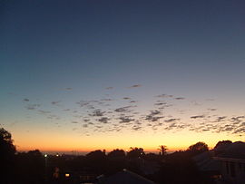
Looking over the west side towards the beach from Doubleview hill
 Doubleview
Population: 7,196 (2006 census)[1] Postcode: 6018 LGA: City of Stirling State District: Scarborough Federal Division: Stirling, Curtin Suburbs around Doubleview: Karrinyup Karrinyup Innaloo Scarborough Doubleview Innaloo Wembley Downs Wembley Downs Woodlands Coordinates: 31°53′46″S 115°46′48″E / 31.896°S 115.780°E
Doubleview is a suburb of Perth, Western Australia. Its Local Government Area is the City of Stirling.
The suburb was named Doubleview due to its views of both the Indian Ocean to the west and the Perth CBD and Darling Range to the east.
Doubleview is generally a residential area, lying between Scarborough to the west and Innaloo to the east on the heavily-trafficked Scarborough Beach Road. Doubleview is near the Scarborough Police and Citizen's Youth Club, a local functions centre at which indoor sports and blue light discos are frequently held for local children.
Education
Doubleview contains one state primary school, Doubleview Primary School (1951). Two other schools, Yuluma (formerly North Innaloo), opened in 1960, and Newborough, opened in 1955, are located just beyond the suburb's eastern and northern boundaries respectively. Prior to the construction of these schools, the area was served by a now defunct school near present-day Westfield Innaloo on Scarborough Beach Road. Small sections in the south of the suburb lie in the catchment areas for Wembley Downs and Woodlands Primary Schools.
There are no high schools within Doubleview; the area lies in the Western Suburbs catchment area, allowing students to attend Churchlands Senior High School (the closest), Carine Senior High School or Shenton College.
Just beyond the suburb's southern boundaries are Hale School, an elite boys' school, and a Catholic school, Holy Rosary Primary School.
References
- ^ Australian Bureau of Statistics (25 October 2007). "Doubleview (State Suburb)". 2006 Census QuickStats. http://www.censusdata.abs.gov.au/ABSNavigation/prenav/LocationSearch?collection=Census&period=2006&areacode=SSC51406&producttype=QuickStats&breadcrumb=PL&action=401. Retrieved 2008-10-05.
Suburbs of the City of Stirling | Perth | Western Australia Coastal Carine · Churchlands · Doubleview · Gwelup · Innaloo · Karrinyup · North Beach · Scarborough · Trigg · Watermans Bay · Wembley Downs¹ · Woodlands

Central Balcatta · Balga · Dianella · Glendalough · Hamersley · Herdsman · Joondanna · Mirrabooka · Nollamara · Osborne Park · Stirling · Tuart Hill · Westminster · Yokine
South Eastern ¹ Suburb shared with other Local Government AreasCategories:- Suburbs of Perth, Western Australia
- Perth, Western Australia geography stubs

Wikimedia Foundation. 2010.