- Yokine, Western Australia
-
Yokine
Perth, Western Australia
 Yokine
Population: 9,591 (2006 census)[1] Postcode: 6060 Location: 7 km (4 mi) N of Perth LGA: City of Stirling State District: Mount Lawley Federal Division: Stirling Suburbs around Yokine: Balcatta Nollamara Dianella Tuart Hill Yokine Dianella Joondanna and Coolbinia Menora Inglewood Coordinates: 31°54′00″S 115°51′04″E / 31.9001°S 115.851°E
Yokine is a suburb of Perth, Western Australia. Its Local Government Area is the City of Stirling.
Contents
History
The name Yokine was derived from the Aboriginal word meaning native dog. The name was chosen because the area is close to Dog Swamp. Its post code is 6060.
Yokine was part of the grant originally allocated to TRC Walters in 1840. Western Australian Golf Limited owned Yokine from at least 1927 and subdivided a small portion of land near the golf course. Before World War II the only house in Yokine was at the eastern end of Royal Street. Yokine experienced a housing boom after the war and much of the area near the golf course was developed by the early 1950s. The southern area grew rapidly in the 1960s and by the late 1970s Yokine was almost completely developed.
Yokine Primary School
Y.P.S. is a Primary School in Yokine on Blythe Ave. The school is small (about 300-350 students) but has a great community. The current principal is Neil Mc Callum.
Dog Swamp Shopping Centre
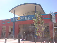 The entrance of the Dog Swamp Shopping Centre.
Dog Swamp Shopping Centre is a major shopping centre, located in Yokine.
The shopping centre was first opened in 1967. Prior to being taken over by the Westpac Diversified Property Trust, the centre was owned by the Foodland Associated Limited Property Trust.[2] As of September 2007, the shopping centre has a 100% occupancy rate.[3]
Major retailers within the centre include: Woolworths, Flight Centre, Civic Video, Subway and TAB.
Amenities
Yokine Reserve - and The West Australian Golf Club
Transport
The suburb is served by a number of Transperth bus routes operated by Path Transit. The 354 and 870[4] (Mirrabooka-Perth) covers the end of Flinders Street and Wanneroo road south to perth, the 346 (Wanneroo-Perth), 347 (Warwick-Perth) and the 363, 373 and 374 (Marangaroo-Perth) covers Wanneroo Road south to Perth.[5]
References
- ^ Australian Bureau of Statistics (25 October 2007). "Yokine (State Suburb)". 2006 Census QuickStats. http://www.censusdata.abs.gov.au/ABSNavigation/prenav/LocationSearch?collection=Census&period=2006&areacode=SSC52591&producttype=QuickStats&breadcrumb=PL&action=401. Retrieved 2008-10-05.
- ^ "Investment Opportunity - FAL Property Trust". Avery Financial Planning. http://www.averys.com.au/client/Investment%20Opportunities/investment%20opportunity%20-%20FAL%20Property%20Trust.pdf. Retrieved 2007-08-03.
- ^ Matabiswana, Thembi. "Property Review". Knight Frank LLP. https://www.westpacfunds.com.au/pdf/lonsec%20master%20report%20westpac%20diversified%20property%20fund%20lonsec%20report.pdf. Retrieved 2007-12-19.
- ^ 354 and 870 Timetable
- ^ 346, 347, 363, 373 and 374 Timetable
External links
Suburbs of the City of Stirling | Perth | Western Australia Coastal Carine · Churchlands · Doubleview · Gwelup · Innaloo · Karrinyup · North Beach · Scarborough · Trigg · Watermans Bay · Wembley Downs¹ · Woodlands

Central Balcatta · Balga · Dianella · Glendalough · Hamersley · Herdsman · Joondanna · Mirrabooka · Nollamara · Osborne Park · Stirling · Tuart Hill · Westminster · Yokine
South Eastern ¹ Suburb shared with other Local Government AreasCategories:- Suburbs of Perth, Western Australia
- Australian Aboriginal placenames


Wikimedia Foundation. 2010.