- Great Eastern Highway
Infobox Australian Road
road_name = Great Eastern Highway
caption = Great Eastern Highway at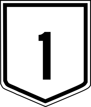
route_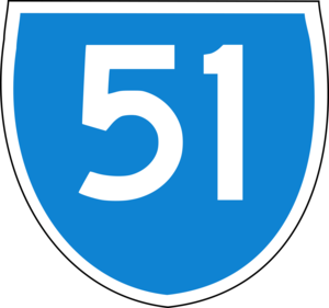
route_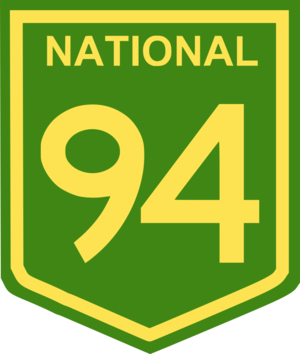
route_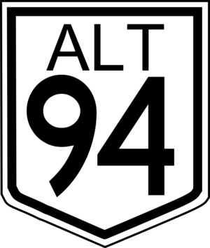
photo = Great_Eastern_Highway_SMC.jpg|400px
length = 595
direction = West-East
start =
finish =
est = 1890s
through = Northam, Merredin, Southern Cross, Coolgardie
route = "Coolgardie - Kalgoorlie"
exits =Albany Highway /The Causeway ,Graham Farmer Freeway /Orrong Road,Tonkin Highway ,Great Eastern Highway Bypass ,Roe Highway ,Great Southern Highway , Northam-Toodyay Road,Coolgardie-Esperance Highway "see also
Major Perth junctions"Great Eastern Highway,
Western Australia is a major road linking Perth with Kalgoorlie. It is a key route for vehicles accessing eastern wheatbelt and the eastern goldfields. It also forms the westernmost convert|595|km|mi|0|lk=on of the main road transportation link between Perth and the east coast of Australia.The road is mostly a federally funded national highway due to its national strategic importance. It is signed as National Highway 94 except for a 9 km stretch between the
Great Eastern Highway Bypass andRoe Highway , and the 40 km section between Coolgardie and Kalgoorlie. It is also signed as Highway 1 betweenThe Causeway andMorrison Road , and State Route 51 between Johnson Street, Guildford, andRoe Highway .The highway mostly runs in parallel with the Mundaring to Kalgoorlie water pipeline, which pipes drinking water drawn from Mundaring Weir near Perth 600 km east to Kalgoorlie. The highway was sealed by 1954. [ [http://www.auslink.gov.au/publications/reports/history.aspx A History of Australian Road and Rail] www.auslink.gov.au,
29 August 2006 . Retrieved17 September 2006 . ] Two highways spur off Great Eastern Highway at various stages; at Perth's eastern metropolitan boundary theGreat Southern Highway begins, which links Perth to such towns as York, Brookton, Narrogin, and Katanning, and 40km prior to arrival at Kalgoorlie theCoolgardie-Esperance Highway begins, which serves, among others Norseman, Esperance, and the east of Australia.Greenmount Hill
Great Eastern Highway is notorious for Greenmount Hill, which is a relatively steep 3 km long hill on Perth's eastern outskirts.
At Greenmount Hill, the highway rises from the
Swan Coastal Plain to theDarling Scarp at Greenmount. The road is a key heavy vehicle route into and out of Perth, and trucks are required to descend the hill at low speed in low gear. Larger trucks are required to stop at the top of the hill and perform a brake check. Extensive signage has been placed on the down-hill side of the hill to alert truck drivers to their obligations.A multiple fatal accident in late 1993 at the intersection with
Roe Highway occurred where a truck lost control coming down hill and failed to stop. This accident led to the construction of a "truck arrester bed " near the bottom of the hill. It has been used in emergencies several times since.In the 1960s, a railway level crossing in Bellevue which had been the scene of many accidents was replaced by a bridge which passes over the main Eastern Railway line.
For a part of the Greenmount Hill route, the Old York Road - named because it had been the York Road route in the nineteenth century - runs parallel but at much steeper grades compared to the highway, and rejoins the highway a hundred metres east of
Chippers Leap at the top of the main climb of the hill.Greenmount to Sawyers Valley
Following the sudden rise of Greenmount Hill, the route from the entrance to
John Forrest National Park through to Sawyers Valley has a rising and falling route with a reduced speed limit from previous years. The reason is that numerous side roads have lower speed limits, and the difference between the highway speed and side road speed was too great in the eyes of transport managers.The localities of Mahogany Creek and Mundaring are dissected by the highway, and a set of traffic lights at Mundaring have been erected.
awyers Valley to The Lakes
Due to Perth's urban expansion and the growth in traffic on Great Eastern Highway, the previously two-way section of road between Sawyers Valley and The Lakes has been re-aligned and upgraded. The rebuilt section between has deep cuttings and is a dual carriageway, the large borrow pits along the rebuilt section being well away from the highway, but very obvious when viewed from the air.
Major settlements
Towns and settlements along the way to Kalgoorlie-Boulder include Northam, Meckering, Cunderdin, Tammin, Kellerberrin, Doodlakine, Merredin, Burracoppin, Bodallin, Moorine Rock, Southern Cross, Yellowdine, Boorabbin, Bullabulling and Coolgardie.
Major Perth Junctions
The Perth section of Great Eastern Highway passes through high density and suburbs, and a vast majority of intersections receive little to no control apart from stop signs. Also noteworthy is the fact that many minor intersections are "one in, one out" intersections, that is, turning across traffic to enter or exit the roadway is not an option.
The Perth section of the highway discussed in this section runs from
The Causeway interchange in Victoria Park to the intersection with Horace Street/Farrall Road in Midvale. The highway then runs through the outer, less urbanised suburbs of Perth, and leaves urban Perth after passing through Mundaring, convert|35|km|mi|0|lk=on north east of the Perth CBD by road. It does not technically leave Perth until shortly after reaching the Great Southern Highway junction, convert|48|km|mi|0|lk=on north east of the Perth CBD by road.Perth to Guildford
Signed as :
*
*Bolton Avenue, Burswood
*
*Kooyong Road, Rivervale
*Belmont Avenue, Rivervale and Belmont
*
*Hardey Road, Ascot and Belmont
*
*Signed as :
*Kalamunda Road, South GuildfordThe highway then crosses the
Helena River and becomes Johnson Street before making a right turn into .Guildford to Midland
Signed as James Street/East Street:
*
*Signed as Great Eastern Highway:
*Signed as :
*Old
Great Northern Highway , Midland
*Helena Street, MidlandEast from Midland
*Lloyd Street, Midland
*
*Horace Street/Farrall Road, Midvale.
ee also
*
Highways in Australia
*List of highways in Western Australia References
*cite book | first=Leigh | last=Edmonds | title=The vital link: a history of Main Roads Western Australia 1926-1996 | publisher=University of Western Australia Press | location=Nedlands, Western Australia | year=1997 | id=ISBN 1-875560-87-4


Wikimedia Foundation. 2010.