- Kherson Governorate
-
Kherson Governorate
Херсонская губерния
Херсонська губернія
A historic map by cartographer Yuly Shokalsky. Capital city Nikolayev (1802-1803)
Kherson (1803-1922)Area 70,600 km² (1920) Population (1914)
- Density3,744,600
p/km²Uyezds 5 (1809-1825)
6 (1825-1828)
7 (1828-1865)
6 (1897)Major towns Kherson, Nikolayev, Odessa Nationalities (1914)
- Ukrainians
- Russians
- Jews
- Other
53%
22%
12%
13%Dates of existence 1802 to 1922 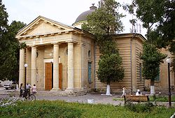
St. Catherine's Cathedral
in
Kherson the governorates capital at the time.The Kherson Governorate (Russian: Херсонская губерния, translit.: Khersonskaya guberniya; Ukrainian: Херсонська губернія, translit.: Khersons`ka huberniya) or Government of Kherson was a guberniya, or administrative territorial unit, in the Southern Ukrainian region, between the Dnieper and Dniester Rivers, of the Russian Empire. It was one of three governorates created in 1802 when the Novorossiya guberniya was abolished. It was known as the Nikolayev Governorate until 1803, when Kherson replaced Nikolayev (Mykolaiv) as the governorate's capital.
The economy of the governorate was mainly based on agriculture. During the grain harvest, thousands of agricultural laborers from the other Ukrainian governorates found work in the area. The industrial part of the economy, consisting primarily of flour milling, distilling, metalworking industry, iron mining, beet-sugar processing, and brick industry, was underdeveloped.
Contents
Administrative divisions

The governorate bordered Bessarabia Governorate to the west, with Kiev and Poltava Governorates to the north, to the east could be found Yekaterinoslav Governorate, and in the southward direction was located Taurida Governorate.
From 1809, the governorate consisted of five uyezds: Kherson, Aleksandriya (Oleksandriia), Ovidiopol, Tiraspol, and Yelisavetgrad (Kirovohrad). The city of Odessa carried a special status. In 1825, The Odessa uyezd was added into the territorial division of the Kherson Governorate. A seventh uyezd — Bobrynets, existed from 1828 to 1865. The cities of Odessa and Nikolayev (in 1803–1861) and their surrounding vicinity were governed separately: Odessa by a gradonachalnik answerable directly to the tsar and (from 1822) the governor-general of Novorossiya and Bessarabia, and Nikolayev by a military governor.
In 1920, while being under Soviet rule, the governorates territory, 70,600 km2 (27,259 sq mi), was divided to form the newer Odessa Governorate. The Kherson Governorate was renamed Nikolayev Governorate in 1921, and in 1922 - merged with the Odessa Governorate. In 1925, the Odessa Governorate was abolished, and its territory was divided into six okrugs: Kherson, Krivoy Rog (Kryvyi Rih), Nikolayev (Mykolaiv), Odessa, Pervomayske (Pershotravneve), and Zinoviivske. In 1932, much of this territory was incorporated into the new Odessa Oblast, now an administrative division of the modern Ukrainian nation, which was divided to form the Mykolaiv Oblast.
Principal cities
Russian Census of 1897
- Odessa - 403 815 (Russian - 198 233, Jewish - 124 511, Ukrainian - 37 925)
- Nikolayev - 92 012 (Russian - 61 023, Jewish - 17 949, Ukrainian - 7 780)
- Yelizavetgrad - 61 488 (Jewish - 23 256, Russian - 21 301, Ukrainian - 14 523)
- Kherson - 59 076 (Russian - 27 902, Jewish - 17 162, Ukrainian - 11 591)
- Tiraspol - 31 616 (Russian - 14 013, Jewish - 8 568, Ukrainian - 3 708)
- Ananyev - 16 684 (Ukrainian - 7 205, Romanian - 4 174, Jewish - 3 514)
- Voznesensk - 15 748 (Jewish - 5 879, Ukrainian - 5 644, Russian - 2 583)
- Bobrinets - 14 281 (Ukrainian - 9 529, Jewish - 3 464, Russian - 837)
- Aleksandriya - 14 007 (Ukrainian - 7 658, Jewish - 3 687, Russian - 2 364)
- Berislav - 12 149 (Ukrainian - 8 852, Jewish - 2 639, Russian - 524)
- Dubossary - 12 089 (Jewish - 5 326, Romanian - 3 383, Ukrainian - 2 841)
- Novogeorgiyevsk - 11 594 (Russian - 6 631, Ukrainian - 3 372, Jewish - 1 424)
- Ochakov - 10 786 (Ukrainian - 5 204, Russian - 3 508, Jewish - 1 430)
- Novomirgorod - 9 364 (Russian - 7 025, Jewish - 1 617, Ukrainian - 572)
- Grigoripol - 7 605 (Romanian - 3 740, Russian - 1 832, Jewish - 832)
- Olviopol - 6 884 (Ukrainian - 5 022, Jewish - 1 480, Russian - 271)
- Ovidiopol - 5 187 (Ukrainian - 2 785, Russian - 1 997, Jewish - 387)
- Mayaki - 4 575 (Russian - 2 865, Ukrainian - 944, Jewish - 644)
Demographics
Until 1858, a third of the population (military settlers, admiralty settlements, foreign colonists, etc.) was subject to martial law. The gubernia had a population of about 245,000 in 1812; 893,000 in 1851; 1,330,000 in 1863; 2,027,000 in 1885; 2,733,600 in 1897; and 3,744,600 in 1914. In the 1850s it consisted of Ukrainians (68–75 %), Romanians (8–11 %), Russians (3–7 %), Jews (6 %), Germans (4 %), Bulgarians (2 %), Serbs, Greeks, and Gypsies. In 1914, Ukrainians composed only 53 % of the population, while Russians made up 22 % and Jews - 12 %. Urban dwellers made up 10–20 % of the population until the 1850s, from where the total number of urban dwellers increased, to about 30 % in 1897. Migration within the Russian Empire mainly accounted for the area's population growth, which is noted by 46 % of the population being born outside of the governorate in 1897.
See also: Jewish agricultural colonies in the Russian Empire.
References and notes
External links
- Kherson Guberniya - Article in Brockhaus and Efron Encyclopedic Dictionary (Russian)
- Kherson Guberniya - Historical coat of arms (Ukrainian)/(English)
- Kherson gubernia - Article in the Encyclopedia of Ukraine
Ukrainian historical regions Kievan Rus' Principalities Medieval epoch Red Ruthenia · Galicia–Volhynia · Bełz Voivodeship · Bracław Voivodeship · Czernihów Voivodeship · Kijów Voivodeship · Podole Voivodeship · Ruthenian VoivodeshipCossack epoch Cossack Hetmanate · Right-bank Ukraine · Left-bank Ukraine · Sloboda Ukraine · Zaporozhian Sich · Dnieper Ukraine · Little RussiaRussian Imperial guberniyas Austro-Hungarian provinces 20th century Ukrainian SSR · Moldavian ASSR · Drohobych Oblast · Izmail Oblast · Crimean Oblast · Lviv Voivodeship · Ternopil Voivodeship · Volhynian Voivodeship · Stanyslaviv Voivodeship · Carpatho-Ukraine · Reichskommissariat Ukraine · Distrikt GalizienGeographical Nadbuzhia · Budzhak · Black Sea Ukraine · Donbas · Dniester Ukraine · Podolia · Pokuttya · Pryazovya · New Russia · Polissya · Podniprovya · Porossia · Prydunavya · Prykarpattia · Porizhia Ukraine · Volhynia · ArtaniyaEthno-Ukrainian regions abroad Subdivisions of the Russian Empire Governorates Azov¹ · *Altai² · Arkhangelsk · Archangelgorod · Astrakhan · Baku · Belgorod · Belarus · Bessarabia · Bratslav · Caucasian · Chernigov · Black Sea · Derbent · Grodno · Georgian-Imeretinskaya · Georgian · Elisabethpol · Erivan · Finland · Iziaslav · Ingermanland · Irkutsk · Kazan · Kaluga · Kiev · Kharkov · Kherson · Kholm · Kovno · Kolyvan · Kostroma · Kursk · Kutaisi · Lithuania · Little Russia · Minsk · Mogilev · Moscow · Nikolayev · Nizhny Novgorod · Novhorod-Siverskyi · Novgorod · Novorossiysk · Olonets · Orenburg · Orel · Penza · Perm · *Petrograd² · Podolia · Polotsk · Poltava · Pskov · Ryazan · Samara · Saint Petersburg · Saratov · Shemakha · Siberia · Simbirsk · Slobodsko-Ukrainian · Slonim · Smolensk · Stavropol · Taurida · Tambov · Tver · Tiflis · Tobolsk · Tomsk · Tula · Ufa · Vilna · Vitebsk · Vladimir · Voznesensk · Vologda · Volhynian · Voronezh · Vyatka · Yaroslavl · Yekaterinoslav · YeniseyskOblasts Amur · Armenian · Batumi · Belostok · Bessarabia · Don Voisko · Dagestan · Zabaikalskaya · Imeretinskaya · Caucasian · Kamchatka · Kars · Caspian · Kwantung · Kuban · Orenburg Kirgiz · Omsk · Primorskaya · Sakhalin · Taurida · Tarnopolsky · Terek · Turgai · Ural · YakutOblasts of Stepnoy Krai Aqmola · Siberia Kirgiz · SemipalatinskOblasts of Turkestan Krai Transcaspian · Samarkand · Semirechenskaya · Syr Darya · Turkestan · FerganaGovernorates of Finland Åbo och Björneborgs · Vaasa · Vyborg · Kuopio · Nyland · St. Michel · Tavastehus · OuluGovernorates of Poland Ostsee Governorates³ Governorates of Galicia *Lvov · *Przemyśl · *Tarnopol · *ChernovtsySpecial Districts Dependent state formations Bukeyev Horde · Emirate of Bukhara · Kokand Khanate · Russian America · Uriankhayskiy Krai · Khanate of Khiva¹ Italics indicates renamed or abolished governorates, oblasts, etc on 1 January 1914.
² An asterisk (*) indicates governorates formed or created with renaming after 1 January 1914.
³ Ostsee or Baltic general-governorship was abolished in 1876.Categories:- Governorates of the Russian Empire
- History of Ukraine
- Historical regions in Ukraine
- States and territories established in 1802
- 1922 disestablishments


Wikimedia Foundation. 2010.