- Taurida Governorate
Infobox Former Subdivision
native_name = Таврическая губернiя
conventional_long_name = Taurida Governorate
common_name = Taurida
subdivision = Governorate
nation =Russian Empire
year_start = 1802
date_start = 8 October
year_end = 1918
date_end = March
p1 = Taurida Oblast
flag_p1 =
s1 = Crimean Autonomous Soviet Socialist Republic
flag_s1 = Flag of the Crimean ASSR, 1938.png
flag_s1 =
stat_year1=1906
stat_pop1=1634700
stat_year2=1918
stat_area2=39497
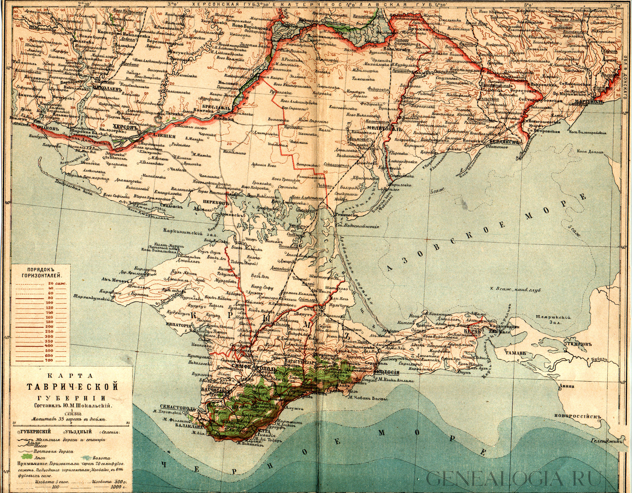
capital = SimferopolRussian Empire . It included theCrimea n peninsula and the mainland between the lowerDnieper River and the coasts of theBlack Sea andSea of Azov It was formed after the defunct Taurida Oblast in was abolished in 1802 in course of Paul I administrative refrom of the South-Western territories that were annexed from theCrimean Khanate . The governorate's centre was the city ofSimferopol . The province was named after the ancient Greek name of Crimea -Taurida .It was devided into eight
uyezd s and two city municipalities (градоначальство), of them on the mainland:
* Berdyansk uyezd (Berdyansk - Бердянскъ)
* Dnieper uyezd (centreAleshki - Алешки)
* Melitopol uyezd (Melitopol - Мелитополь)and in Crimea:
* Eupatoria uyezd (Eupatoria - Евпаторiя)
* Perekop uyezd (Perekop - Перекопъ)
* Simferopol uyezd (Simferopol - Симферополь)
* Theodosia uyezd (Theodosia - Ѳеодосiя)
* Yalta uyezd (Yalta - Ялта)
* city ofKerch - Керчь
* city of Sebastopol - СевастопольGeography
The mainland and the peninsular parts of the region differed a lot.The total area of the governorate was 39,497 km² of which the mainland portion consisted of 23,583 km² and is largely black earth
steppe land. The population of the whole region was 1,634,700 in 1906. At that time, mainland part of the governorate was mostly populated byUkrainians andRussians but had significant ethnic minorities of Germans,Bulgarians , andArmenians andJews , while major ethnic groups of the Crimean peninsula wereCrimean Tatars andRussians with German, Greek, Armenian and Karaim minorities. Major urban centres wereSimferopol ,Sevastopol ,Theodosia ,Bakhchisaray andYalta in Crimea, and Aleshki (now Tsyurupynsk),Berdyansk , andMelitopol on the mainland.History
:"For further history see:
History of Crimea "In 1783, the
Khanate of Crimea was annexed by Catherine the Great’s Russia. Soon after this the TauridaOblast (province) was established. During the reign of Paul I the oblast was abolished, but soon (in 1802) re-established as a Governorate (guberniya). It was a part of the Russian Empire until the Russian Revolution of 1918.Following the 1917
October Revolution , the governorate was reformed as the "Taurida Soviet Socialist Republic" (Russian: Советская Социалистическая Республика Тавриды - "Sovetskaya Sotsialisticheskaya Respublika Tavridy") briefly in early 1918 before being overrun by theWorld War I Central Powers . After the reassertion of Soviet control in 1921, the lands of the governorate were divided between the peninsularCrimean Autonomous Soviet Socialist Republic under theRussian SFSR and the mainland portions which accrued to theUkrainian SSR and were divided between what would become (in 1932) the Kherson and Dnepropetrovsk Oblasts. Today the mainland portion forms parts ofKherson andZaporizhia Oblast s while Crimea is the Autonomous Republic of Crimea, allsubdivisions of Ukraine .References
*1911
External links
* [http://feefhs.org/maps/RUSE/RE-CRIME.HTML Map of Taurida (1882)]
Wikimedia Foundation. 2010.