- Mykolaiv Oblast
-
Mykolaiv Oblast
Миколаївська область
Mykolayivs’ka oblast’— Oblast — 
Flag
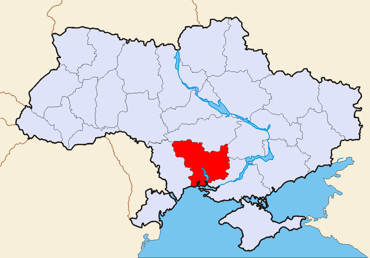
Coat of armsNickname(s): Миколаївщина (Mykolayivschyna) Location of Mykolaiv Oblast (red) within Ukraine (blue)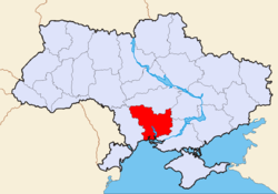
Country  Ukraine
Admin. center Mykolaiv Government - Governor Mykola Kruhlov[1] (Party of Regions[1]) - Oblast council ? seats - Chairperson Tetiana Vasylivna Demchenko (Party of Regions) Area - Total 24,598 km2 (9,497.3 sq mi) Area rank Ranked 14th Population (2006) - Total 1,217,103 - Rank Ranked 18th - Density 49.5/km2 (128.2/sq mi) Time zone EET (UTC+2) - Summer (DST) EEST (UTC+3) Postal code 54000-56999 Area code +380-51 ISO 3166 code UA-48 Raions 19 Cities of oblast subordinance 5 Cities (total) 9 Towns 20 Villages 900 FIPS 10-4 UP16 Website www.mykolayiv-oda.gov.ua
www.kmu.gov.uaMykolaiv Oblast (Ukrainian: Миколаївська область, translit. Mykolayivs’ka oblast’; also referred to as Mykolayivschyna - Ukrainian: Миколаївщина) is an oblast (province) of Ukraine. The administrative center of the oblast is the city of Mykolayiv.
Contents
Geography
The Mykolaiv Oblast is located in the southern half of Ukraine. Its area (24,600 km²), comprises about 4.07% of the total area of Ukraine.
The Mykolaiv Oblast borders upon the Odesa Oblast in the west-southwest, the Kirovohrad Oblast in the north, the Dnipropetrovsk Oblast in the northeast, and the Kherson Oblast on the southeast.
On the south the obalst' is also bordered by the Black Sea. On the shoreline, there are several ports and the Mykolaiv International Airport.
Points of interest
The following historic-cultural sites were nominated for the Seven Wonders of Ukraine.
- Olbia
- Dykyỹ sad (Wild Garden)
Demographics
The current estimated population is 1.2 million people (as of 2005). The greater part of the oblast's population resides in urban type settlements (66%), with the remainder residing in agricultural areas. Also, almost 60% of the urban population resides in Mykolayiv, the industrial, cultural and administrative center of Mykolayiv Oblast.
The oblast's population density is one of the lowest in Ukraine – 52 people per 1 km². The oblast' is ranked 18 by the percentage of the population of Ukraine, that the Mykolaiv Oblast contain, which os 2.6%.
Administrative divisions
The Mykolaiv Oblast formed in September 1937. It is subdivided into: 19 raions (administrative districts), and 5 of its cities are designated as separate raions within the oblast.
The following data incorporates the number of each type of administrative divisions of the Mykolaiv Oblast:
- Administrative Center - 1 (Mykolaiv)
- Raions — 19;
- City raions — 4;
- Settlements — 922, including:
- Villages — 896;
- Cities/Towns — 26, including:
- Urban-type settlement — 17;
- Cities — 9, including:
- Cities of oblast' subordinance — 5;
- Cities of raion subordinance — 4;
- Selsovets — 287.
The local administration of the oblast' is controlled by the Mykolaiv Oblast Rada. The governor of the oblast' is the Mykolaiv Oblast Rada speaker, appointed by the President of Ukraine.
Nomenclature
Most of Ukraine's oblasts are named after their capital cities, officially referred to as "oblast centers" (Ukrainian: обласний центр, translit. oblasnyi tsentr). The name of each oblast is a relative adjective, formed by adding a feminine suffix to the name of respective center city: Mykolaiv is the center of the Mykolayivs’ka oblast’ (Mykolaiv Oblast). Most oblasts are also sometimes referred to in a feminine noun form, following the convention of traditional regional place names, ending with the suffix "-shchyna", as is the case with the Mykolaiv Oblast, Mykolayivschyna.
See also
- Subdivisions of Ukraine
- Kherson Governorate
References
- ^ a b President appoints 14 regional governors, Interfax-Ukraine (March 18, 2010)
External links
- State Administration of Mykolaiv Oblast - official site (Ukrainian)/(Russian)/(English)
- Information Card of the Region - official site of the Cabinet of Ministers of Ukraine
Administrative center: Mykolaiv Raions Arbuzynskyi · Bashtanskyi · Berezanskyi · Bereznehuvatskyi · Bratskyi · Domanivskyi · Kazankivskyi · Kryvoozerskyi · Mykolaivskyi · Novobuzkyi · Novoodeskyi · Ochakivskyi · Pervomaiskyi · Snihurivskyi · Veselynivskyi · Voznesenskyi · Vradiyivskyi · Yelanetskyi · Zhovtnevyi

Cities Bashtanka · Mykolaiv · Novyi Buh · Nova Odesa · Ochakiv · Pervomaisk · Snihurivka · Voznesensk · YuzhnoukrainskUrban-type
settlementsArbuzynka · Berezanka · Bereznehuvate · Bratske · Domanivka · Kazanka · Kostiantynivka · Kryve Ozero · Kudriavtsivka · Oleksandrivka · Olshanske · Pervomayske · Pidhorodna · Veselynove · Voskresenske · Vradiyivka · Yelanets · more...Villages Administrative divisions of UkraineCapital: Kiev Oblasts Cherkasy · Chernihiv · Chernivtsi · Dnipropetrovsk · Donetsk · Ivano-Frankivsk · Kharkiv · Kherson · Khmelnytskyi · Kiev · Kirovohrad · Luhansk · Lviv · Mykolaiv · Odessa · Poltava · Rivne · Sumy · Ternopil · Vinnytsia · Volyn · Zakarpattia · Zaporizhia · ZhytomyrCities with special status Autonomous Republic Administrative centers Cherkasy · Chernihiv · Chernivtsi · Dnipropetrovsk · Donetsk · Ivano-Frankivsk · Kharkiv · Kherson · Khmelnytskyi · Kiev · Kirovohrad · Luhansk · Lutsk · Lviv · Mykolaiv · Odessa · Poltava · Rivne · Sevastopol · Simferopol · Sumy · Ternopil · Uzhhorod · Vinnytsia · Zaporizhia · ZhytomyrCategories:- Mykolaiv Oblast
- Oblasts of Ukraine
Wikimedia Foundation. 2010.