- Khmelnytskyi Oblast
Infobox Ukrainian oblast
Name = Khmelnytskyi Oblast
UkrainianName = Хмельницька область
TransliteratedName = Khmel’nyts’ka oblast’
Nickname = Хмельниччинаspaces|2(Ukrainian) "Khmelnychchyna"spaces|2(transliteration )
Ukraine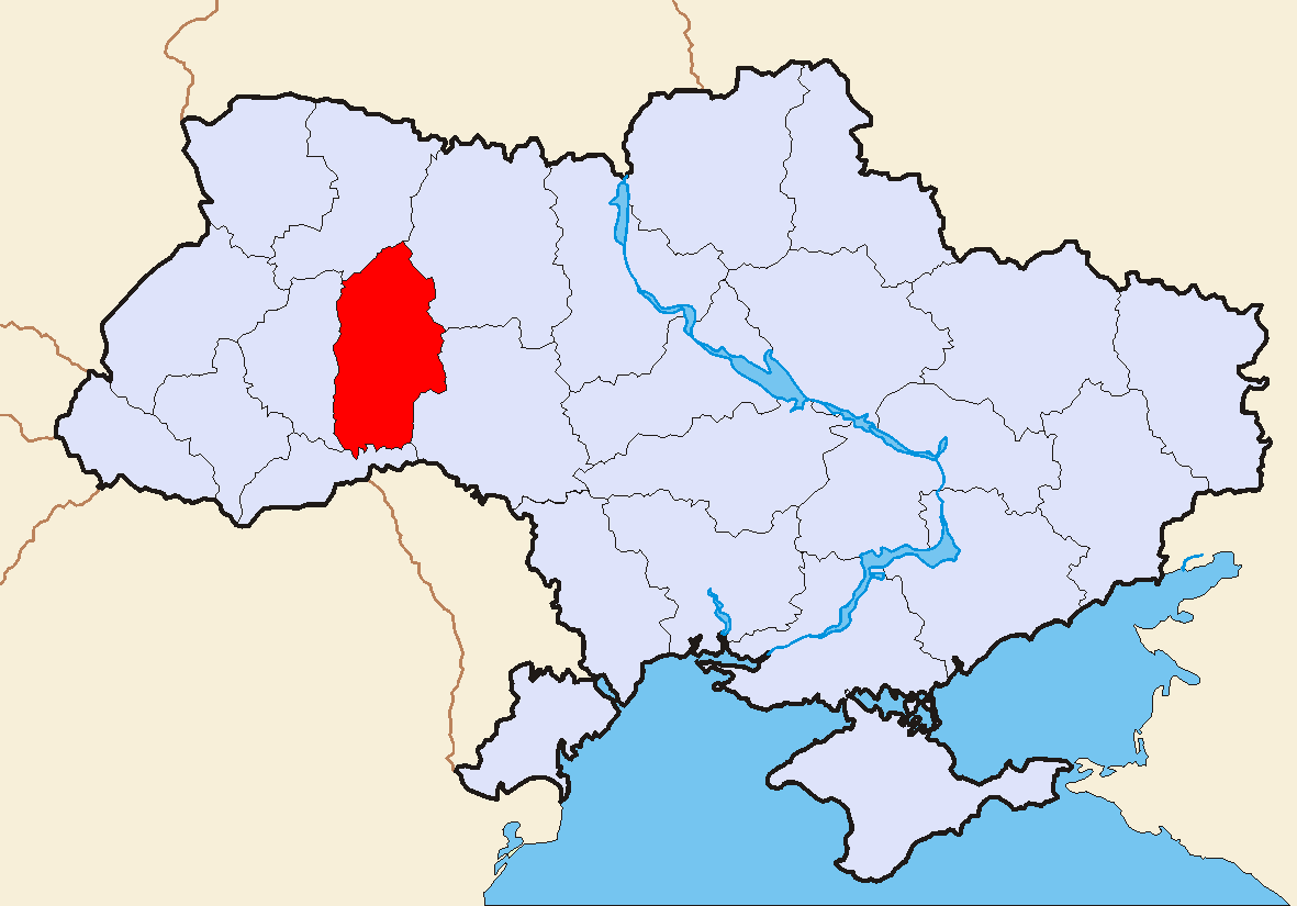
Administrative_center = Khmelnytskyi
GovernorName = Oleksandr Mykolayovych Bukhanevych
GovernorParty = ?
ChairmanName = Ivan Vasylyovych Hladuniak
ChairmanParty = ?
CouncilSeats = ?
Raions = 20
CityRaions = 4
Cities = 13
CMTs = 24
Villages = 1,416
AreaRank = 19th
TotalArea = 20,645
LandArea = ?
WaterArea = ?
PercentWater = ?
PopulationYear = 2006
Population_rank = ?
Population = 1,367,892
Density = 68
Population_Growth = ?
SalaryYear = ?
Salary_rank = ?
Salary = ?
Salary_Growth = ?
PostalAbbreviation = 29000-31999
ISOCode =
FIPSRegionCode =
PhoneCode = +380-38
Website = adm-km.gov.uaKhmelnytskyi Oblast ( _uk. Хмельницька область, translit. "Khmel’nyts’ka oblast’") is an oblast (province) of western
Ukraine . The administrative center of the oblast is the city of Khmelnytskyi.The current estimated population is around 1,401,140 (as of 2004).
Geography
Khmelnytskyi Oblast has a total area of 20,600 km² (3.4% of the total area of Ukraine) is located between 48°27' and 50°37' north latitude and between 26°09' and 27°56' east longitude. It is 220 km long when measured from north to south, and is 120 km in length when measured from east to west. The oblast borders the
Rivne Oblast to the northwest, theZhytomyr Oblast to the northeast, theVinnytsia Oblast to the east, theChernivtsi Oblast to the south, and theTernopil Oblast to the west.Elevations
The Podillia highland (270—370 meters above
sea-level ) occupies the central area of the Khmelnytskyi Oblast. The northwestern areas of the oblast are part of theVolyn highland (highest point — 329 m above sea-level), while to the north, the oblast claims a part of the historic region of Polissia (highest point — 200-250 m above sea-level). The southwestern territory of the Khmelnytskyi Oblast is crossed by theTovtry range ( _uk. Товтровий кряж, translit. "Tovtryi kryazh"), which includes MountVelyka Buhaikha ( _uk. Велика Бугаїха), the highest point of oblast at 409 m above sea-level. The extreme south of the oblast has a surface with the canyon-like river valleys. TheDneister Reservoir located there is the lowest point of the oblast (121 m above sea-level) .Rivers and Lakes
There are 120 rivers with a length of 10 km or more in the Khmelnytskyi Oblast. The largest of these are the
Dniester River (which flows for 160 km within the oblast), as well as itstributaries : Smotrych, Ushytsia, and the Zbruch — and theSouthern Buh River (which flows for 120 km within the oblast), as well as its tributaries: Buzhok, Ikva, and Vovk. The rivers of the Dnieper River's basin — Horyn, Khmora, and Sluch Rivers also run through the oblast. The oblast's lakes are located mostly in basin of the Horyn River. The largest reservoir in the oblast is the Dniester Reservoir.There are 1858 ponds and/or reservoirs in the oblast. The largest of these include Shchedrivske (with a surface area of 12.58 km²), Novostavske (with a surface area of 11.68 km²), and Kuzmynske (with a surface area of 7.65 km²).
History
Khmelnytskyi Oblast was created on
September 22 ,1937 as the Kamianets-Podilskyi Oblast ( _uk. Кам’янець-Подільськa область, translit., "Kamyanets-Podil'ska oblast’"). In March of 1941 the administrative center of the oblast was moved fromKamianets-Podilskyi to the city of Proskuriv ("now Khmelnytskyi"). In 1954, Proskuriv was renamed Khmelnytskyi, and soon afterward, the oblast was renamed to Khmelnytskyi Oblast.Administrative divisions
The oblast is subdivided into 20
raions ("administrative districts"). It consists of 6 municipalities, 13 cities, 24 towns, and more than 1,417 villages.The following data incorporates the number of each type of administrative divisions of Kiev Oblast:
* Administrative Center - 1 (Khmelnytskyi)
*Raions — 20;
* City raions — 0;
* Settlements — 1452, including:
**Villages — 1415;
** Cities/Towns — 37, including:
***Urban-type settlement — 24;
*** Cities — 13, including:
**** Cities of oblast' subordinance — 6;
**** Cities of raion subordinance — 7;
*Selsovet s — 568.The local administration of the oblast' is controlled by the Kiev Oblast Rada. The governor of the oblast' is the Kiev Oblast Rada speaker, appointed by the
President of Ukraine .Raions
{
|-
* Bilohirskyi
* Chemerovetskyi
* Derazhnianskyi
* Dunaievetskyi
* Horodotskyi
* Iziaslavskyi
* Kamianets-Podilskyi
* Khmelnytskyi
* Krasylivskyi
* Letychivskyi
* Novoushytskyi
* Polonskyi
* Shepetivskyi
* Slavutskyi
* Starokostiantynivskyi
* Starosyniavskyi
* Teofipolskyi
* Vinkovetskyi
* Volochyskyi
* YarmolynetskyiMunicipalities
*
Kamianets-Podilskyi
*Khmelnytskyi
*Netishyn
*Shepetivka
*Slavuta
*Starokostiantyniv Cities
{
|-
*Derazhnya
* Dunaivtsi
* Horodok
*Izyaslav
*Kamianets-Podilskyi
*Khmelnytskyi
*Krasyliv
*Netishyn
*Polonne
*Shepetivka
*Slavuta
*Starokostiantyniv
*Volochysk Towns
{
|-
*Antoniny
*Bazaliya
*Bilohirya
*Chemerivtsi
*Chornyi Ostriv
* Dunaivtsi
*Hrytsiv
*Letychiv
*Lozove
*Medzhybizh
*Narkevychi
*Nova Ushytsya
*Poninka
*Sataniv
* Smotrych
*Stara Synyava
*Stara Ushytsya
*Teofipol
*Vinkivtsi
*Viytivtsi
*Vovkovyntsi
* Yampil
*Yarmolyntsi
*Zakupne Demographics
Khmelnytskyi Oblast's population is 1,401,140 as of
January 1 ,2004 . As of 2002, the oblast ranks 13th by population in Ukraine. The population density is 69.5/km².Pensioners make up 453,800 thousand people or 31,7% of population. The
birth rate per 1,000 residents is 8.3, and thedeath rate — per 1000 residents – 16.1. [http://www.kmu.gov.ua/control/en/publish/article?art_id=116766&cat_id=32596/ Cabinet of Ministers of Ukraine - Khmelnytsky Region] URL accessed on November 26, 2006] The urban population, according to the 2001 Ukrainian Census data, accounted for 729,600 people, or 51%, and the rural population — for 701,200 people, or 49%. [ [http://www.ukrcensus.gov.ua/eng/regions/region_khmel// Ukrcensus.gov.ua - Khmel'nyts'kyi region region] URL accessed on January 11, 2007]According to the data, the number of men accounted for 659,900 people, or 46.1%, that of women — 770,900 people, or 53.9%.
Economy
The economy of the oblast mostly deals with the
energy industry ,transport andagriculture . The oblast is situated at a historical crossroad of therailway andhighway routes connectingCentral Europe toBlack Sea coast andRussia (with city ofShepetivka being the most important railway junction). The "Khmelnyts’ka" nuclear power plant in the city ofNetishyn is the most important industrial company of the oblast. Notablemachinery ,armament andchemical industries are also present.Nomenclature
Most of Ukraine's oblasts are named after their
capital cities, officially referred to as "oblast centers" ( _uk. обласний центр, translit. "oblasnyi tsentr"). The name of each oblast is arelative adjective , formed by adding a femininesuffix to the name of respective center city: "Khmelnytskyi" is the center of the "Khmelnyts’ka oblast’" (Khmelnytskyi Oblast).ee also
*
Subdivisions of Ukraine
*Podolia References
:Inline
* [http://www.kmu.gov.ua/control/en/publish/article?art_id=116766&cat_id=32596/ Information Card of the Region] - Official site of the Cabinet of Ministers of UkraineExternal links
* [http://www.adm-km.gov.ua/new/ adm-km.gov.ua] - Official website of Khmelnytskyi Oblast Administration uk icon
Wikimedia Foundation. 2010.