- Clinton-Sherman Industrial Airpark
-
Coordinates: 35°20′23″N 099°12′02″W / 35.33972°N 99.20056°W
Clinton-Sherman Industrial Airpark 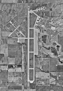
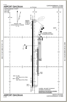
Airfield diagram from Federal Aviation Administration IATA: CSM – ICAO: KCSM – FAA LID: CSM Summary Airport type Public Owner Oklahoma Space Industry Development Authority Serves Clinton, Oklahoma Location Burns Flat, Oklahoma Elevation AMSL 1,922 ft / 586 m Runways Direction Length Surface ft m 17R/35L 13,503 4,116 Concrete 17L/35R 5,193 1,583 Concrete Statistics (2006) Aircraft operations 49,500 Source: Federal Aviation Administration[1] - For the military use of the facility before 1969 see Clinton-Sherman Air Force Base
The Clinton-Sherman Industrial Airpark, also known as the Oklahoma Spaceport is a newly authorized spaceport near Burns Flat, Oklahoma, in the western part of the state.[2] The Federal Aviation Administration (FAA) granted a license to the site in June 2006 to the Oklahoma Space Industry Development Authority (OSIDA) to "oversee the takeoff and landing of suborbital, reusable launch vehicles".[2] The license expires in five years and requires regular safety inspections by the FAA. Individual operators must also secure a separate license in order to make space flights from the facility.
Contents
Facilities
The airpark is at the site of a public airfield known as Clinton-Sherman Airport (IATA: CSM, ICAO: KCSM). The airport covers an area of 1,690 acres (680 ha) which contains two concrete paved runways: 17R/35L measuring 13,503 x 150 ft (46 m). and 17L/35R measuring 5,193 x 75 ft. (1,583 x 23 m). The longer of these, at 13,503 x 150 ft (4,116 x 46 m) is a major benefit for use as a spaceport.
For the 12-month period ending May 2, 2006, the airport had 49,500 aircraft operations, an average of 135 per day: 98% military and 2% general aviation.[1]
The location is a 2,700 acre (10.8 km²) facility located near transportation corridors such as Interstate 35 and Interstate 40. There are 96 acres (384,000 m²) of parking space able to support large commercial aircraft. There are six commercial aircraft hangars and a 50,000 square-foot (4,500 m²) manufacturing facility with loading docks adjacent to a railway spur.[3]
History
For more details on this topic, see Clinton-Sherman Air Force Base.The United States Navy established a naval air station on 5,000 acres (20 km²) at this location in 1942 to train pilots during World War II. The outlines of the original runways are still visible in some overhead photos of the current airport. After the war ended, the naval air station was closed and the site was temporarily turned into a civilian airport. A portion of the airfield was leased by Sherman Iron Works for use in salvaging surplus combat aircraft and parts from thousands of surplus aircraft from the war. The military returned in 1954 and converted the site into an Air Force facility known as Clinton-Sherman Air Force Base. The name is derived from the nearby city of Clinton and the Sherman Iron Works. The Air Force built the long runway to support B-52 bombers. The base was closed at the end of 1969, although the military still intermittently uses the airport for training purposes, such as touch-and-go landings of tankers and cargo aircraft. The base has now become the Clinton-Sherman Industrial Airpark, home to a limited amount of industrial and general aviation activity.[4][5]
Licensing
"This is a tremendous opportunity for Oklahoma," said OSIDA Director Bill Khourie. "The benefits are just enormous as to what can branch out from this." He claims that this site will have advantages over the other licensed sites because it is the first that will use the national airspace system without government restrictions. Khourie said, "Other spaceports are utilizing restricted airspace and must receive approval from military agencies. We are not going to be restricted by that situation. That's a plus for the operators operating out of this facility."[2]
The receipt of a launch site operator license gives Oklahoma a good position in the nascent space tourism industry — a market which is also being targeted by California, New Mexico, Florida and Wisconsin, as well as Singapore and the United Arab Emirates.[6] Other spaceport licenses have already been issued to two facilities in California and one each in Florida, Virginia and Alaska, according to the FAA.[2]
Operations
One company, Rocketplane Kistler, formerly based in Oklahoma, had plans to build a spacecraft and, as of 2006, had plans to offer commercial space flights from the Oklahoma Spaceport by 2009.[7] Rocketplane Kistler is an umbrella enterprise comprising two private aerospace firms dedicated to establishing a reusable space craft industry; Rocketplane Limited, Inc. and Kistler Aerospace.[citation needed] Before a vehicle could be launched, the individual operator would still be required to obtain a separate launch license from the FAA. Rocketplane is working on completing its license application and expects to begin "a fairly extensive flight test program" in 2007. The company's executive vice president, David Urie, said he was "elated" to hear that the proposed spaceport had received its license. "It's extremely important...It was an absolute necessity for our plans that they've achieved this licensing. Rocketplane Kistler, Global and Rocketplane Holdings declared Chapter 7 bankruptcy in 2010. "[6]
Armadillo Aerospace conducted flight test Activities at the Oklahoma Spaceport in 2004 through 2009, including tests of a VTVL Lander and a Rocket Racer for the Rocket Racing League.
References
- ^ a b FAA Airport Master Record for CSM (Form 5010 PDF), effective 2007-10-25
- ^ a b c d Murphy, Sean (14 June 2006). "FAA issues Oklahoma spaceport license". The Mercury News. http://www.mercurynews.com/mld/mercurynews/news/breaking_news/14818115.htm. Retrieved 2006-06-26.
- ^ "Wide, Open Space Dedicated to the Aerospace Industries of the Future!". Oklahoma Space Industry Development Authority. http://www.okspaceport.state.ok.us/index.html. Retrieved 2006-06-26.
- ^ Foust, Jeff (7 June 2004). "Little spaceport on the prairie". The Space Review. http://www.thespacereview.com/article/157/1. Retrieved 2006-06-26.
- ^ "Facility History". Oklahoma Space Industry Development Authority. http://www.okspaceport.state.ok.us/facilityhistory.html. Retrieved 2006-06-26.
- ^ a b Boyle, Alan (13 June 2006). "Regulators OK Oklahoma spaceport - Suborbital test flights could begin in 2007, setting stage for tourists". MSNBC. http://msnbc.msn.com/id/13304491. Retrieved 2006-06-26.
- ^ Foust, Jeff (2009-07-31). "Rocketplane’s woes". Personal Spaceflight. http://www.personalspaceflight.info/2009/07/31/rocketplanes-woes/. Retrieved 2009-09-07.
External links
- Oklahoma Space Industry Development Authority
- FAA Airport Diagram (PDF), effective 20 October 2011
- Resources for this airport:
- AirNav airport information for KCSM
- ASN accident history for CSM
- FlightAware airport information and live flight tracker
- NOAA/NWS latest weather observations
- SkyVector aeronautical chart, Terminal Procedures for KCSM
Spaceports Asia and the
Middle EastEurope  FKA: Kapustin Yar · Plesetsk ·
  SSC: Esrange
North America  CAF / CSA: Fort Churchill ·
  NASA: KSC · Wallops · DoD: Cape Canaveral (ER) · Vandenberg (WR) · Private: Corn Ranch · Jacksonville · Kodiak · Mid-Atlantic Regional Spaceport · Mojave · Oklahoma · Spaceport America
South America  FAB / AEB: Barreira do Inferno · Alcântara ·
  Private: Spaceport Curaçao ·
  ESA / CNES: Guiana/Kourou
Pacific Categories:- Economy of Oklahoma
- Spaceports
- Space Shuttle landing sites
- Buildings and structures in Washita County, Oklahoma


Wikimedia Foundation. 2010.