- Neumark
-
For other uses, see Neumark (disambiguation).
Neumark or Ostbrandenburg (de)
Nowa Marchia (pl)
terra trans Oderam (la)
Neumark or East BrandenburgRegion of the Margraviate of Brandenburg ← 
1252–1945  →
→
Coat of arms of Brandenburg,
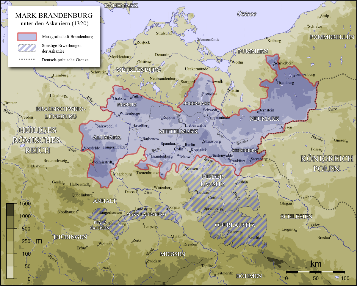
shared by the NeumarkThe Margraviate of Brandenburg ca 1320, showing the Neumark as the portion reaching out to the east. Cross-hatched are territories also acquired by the House of Ascania outside of Brandenburg.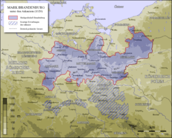
Capital Soldin Historical era Middle Ages,
Modern era- Lubusz Land bought
by Mgvt Brandenburg
and Abp Magdeburg
1252- Pawned to the
Teutonic Knights
1402–63a- Partitioned to form
Brandenburg-Küstrin
1535–71- Electors inherited
Duchy of Prussia
1618- Expanded on
abolition of
Posen-West Prussia
1938- Potsdam Conference
awarded most of
Neumark to Poland
17 July – 2 Aug 1945- Reorganised to
Lubusz Voivodeship
1 January 1999Today part of  Poland
 Germany
a: Pawned to the Teutonic Knights in 1402, who gained complete control of the territory by 1429. Pawned back to Brandenburg in 1455, whose reacquisition of the territory was completed in 1463. The Neumark (
 listen (help·info)), also known as the New March (Polish: Nowa Marchia) or as East Brandenburg (German: Ostbrandenburg (help·info)), comprised a region of the Prussian province of Brandenburg, Germany, located east of the Oder River in territory which became part of Poland in 1945.
Called the Lubusz Land while part of medieval Poland, the territory later known as the Neumark gradually became part of the German Margraviate of Brandenburg from the mid-13th century. As Brandenburg-Küstrin the Neumark formed an independent state of the Holy Roman Empire from 1535 to 1571; after the death of the margrave John, a younger son of Joachim I Nestor, Elector of Brandenburg, it returned to Elector John George, the margrave's nephew and Joachim I Nestor's grandson. With the rest of the Electorate of Brandenburg, it became part of the Kingdom of Prussia in 1701 and part of the German Empire in 1871 when each of those states first formed. After World War I the entirely ethnic German Neumark remained inside the new Weimar Republic of Germany.
After World War II the Potsdam Conference assigned the majority of the Neumark to Polish administration, and since 1945 it remains part of Poland. Polish settlers largely replaced the expelled German population. Most of the Polish territory became part of the Lubusz Voivodeship, while the northern towns Choszczno (Arnswalde), Myślibórz (Soldin), and Chojna (Königsberg in der Neumark) belong to the West Pomeranian Voivodeship. Some territory near Cottbus, which was administratively part of the district of Frankfurt an der Oder (coterminous with the Neumark) after the 1815 Congress of Vienna, became part of East Germany in the 1940s, becoming part of Germany after reunification in 1990.
Contents
Location
The Oder marked the borders of the Neumark in the west and south; in the north it bordered on Pomerania, and in the east on Poland (and, after the Second Partition of Poland, by the Province of Posen). The Warta and Noteć Rivers and their swamp regions dominated the landscape of the region. At the time of the Neumark's greatest territorial extent (at the end of the 17th century), the region included the Kreise (districts) and towns of:
- Königsberg in der Neumark (Chojna)
- Soldin (Myślibórz)
- Landsberg an der Warthe (Gorzów Wielkopolski)
- Friedeberg (Strzelce Krajeńskie)
- Arnswalde (Choszczno)
- Dramburg (Drawsko Pomorskie)
- Schivelbein (Świdwin)
- Sternberg (Torzym)
- Crossen an der Oder (Krosno Odrzańskie)
History
Ancient history
In the Bronze Age the area which became the Neumark fell within the area of the Lusatian culture. In the Iron Age the Jastorf culture operated in this region, identified sometimes with Germanic and sometimes with Celtic tribes.
As its inhabitants moved westward, the region became depopulated during the Migration Period.[citation needed] After AD 500 West Slavic tribes gradually repopulated the area, which became a forest borderland between Pomerania and Greater Poland. According to the Bavarian Geographer's description, the Miloxi inhabited the future Neumark region: they had 47 settlements between the Oder and Poznań.
Middle Ages
 Lubusz Land — core of the future Neumark — during the Piast period (marked in yellow)
The region came under the sovereignty of the first Polish state during the 10th-century rule of Mieszko I (died 992) and Bolesław I (ruled 992–1025), Dukes of the Polans.[1] Polish rulers incorporated the future Neumark territory as the Lubusz Land: by the beginning of the 13th century it had a thinly-spread population of Poles.
The Ascanian margraves of Brandenburg, starting with Albert the Bear (ruled 1157–70), aspired to extend their dominion east of the Oder. They had gained a foothold east of the river by 1242 and in 1252 the Margraviate of Brandenburg and the Archbishopric of Magdeburg purchased the Lubusz Land. In 1253 they founded Frankfurt an der Oder as a river-crossing and as a staging-point for further expansion easward.[2] Through land purchases, marriage pacts, and services to Poland's Piast dynasty, the Ascanians extended their territory eastward to the Drawa River and northward to the Parsęta River. For instance, the Polish castellany of Zantoch, an important base and crossing point over the Warta near its junction with the Noteć, was sought by Pomerania. To relieve himself of the trouble of maintaining the fortress, Duke Przemysł I of Greater Poland granted the castellany to Margrave Conrad as a dowry for his daughter Konstancja. To safeguard the region Margrave John I founded the town of Landsberg an der Warthe (now Gorzów Wielkopolski) in 1257. The Templars sold Soldin to the Ascanians in 1261, and the town began to become a center for the region.
Beginning in the 1230s, Low-German–speaking colonists from the Holy Roman Empire began settling north and south of the Warta and Noteć Rivers upon the initiative of Pomeranian and Polish lords; see Ostsiedlung. The lords invited members of the Knights Templar and Knights Hospitaller to establish monasteries, near which settlements began to develop. To fortify the borderland Pomeranian and Polish dukes built castles in the north, around which settlements also grew.
Most of the colonists who settled in Brandenburg's new eastern territory came from Magdeburg or the Altmark ("Old March"). Unlike in the rest of Brandenburg (where the Ascanians settled knights in open villages) the margraves began constructing castles in their land east of the Oder to guard against Poland.[3] The Slavic inhabitants of the region gradually became Germanized. Because the new Terra trans Oderam, or "land across the Oder", formed an extension of the Margraviate of Brandenburg, it became known as the Neumark ("New March") after the middle of the 15th century.
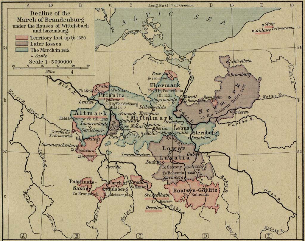
With the extinction of the Ascanian line in 1320, Brandenburg's interest in the Neumark decreased. Neither the margraves of the Wittelsbach (1323–73) nor those of the Luxembourg dynasties concerned themselves with developing their eastern-most territory further. The political vacuum allowed Poland to reassert its influence in the area, while robber barons terrorized the populace.
The Teutonic Knights
See also: Treaties of Cölln and MeweBrandenburg pawned the Neumark to the Teutonic Knights in 1402, and it passed completely under their control in 1429, although the Order neglected the region as well. After the Teutonic Knights' defeat in the Battle of Grunwald (Tannenberg) in 1410, the future Grand Master Michael Küchmeister von Sternberg used the Neumark as a staging ground for an army of German and Hungarian mercenaries which he later used against the forces of King Władysław II Jagiełło of Poland. This allowed the Order to retain much of its territory in the First Peace of Thorn in 1411.[4]
In 1454/1455 the Knights' mismanagement led to their pawning of the Neumark back to Brandenburg, by then led by Elector Frederick II of the Hohenzollern dynasty (Treaties of Cölln and Mewe). After Frederick completed the re-acquisition of Neumark in 1463 for 40,000 guilders, the region belonged to Brandenburg for the following centuries, with the exception of the time between 1535-1571. Frederick II wrote for his successors "that the said land, the New Mark, shall belong to German territory and to the worshipful Electorate of the Mark of Brandenburg, with which it was incorporated at the institution of the Electorate, and shall so remain, and shall never pass to those who speak not the German tongue".[5]
Brandenburg-Küstrin
Margraviate of Brandenburg-Küstrin
Markgrafschaft Brandenburg-KüstrinState of the Holy Roman Empire ← 
1535–1571 →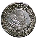
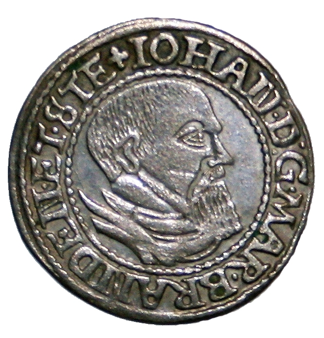
A groschen of John, Margrave of Brandenburg-Küstrin, 1545 Coat of arms of Brandenburg Capital Soldin (to 1548)a
Küstrin (from 1548)bGovernment Principality Margrave John Historical era Early Modern age - Partitioned from
Brandenburg
1535- Reabsorbed into
Brandenburg
1571Today part of Poland
Germanya: Soldin is now the Polish city of Myślibórz
b: Küstrin straddled the Oder-Neisse line, so was partitioned after World War II and is now Kostrzyn nad Odrą in Poland and the Küstriner Vorland in Germany.After the death of Elector Joachim I Nestor in 1535, Brandenburg's territory west of the Oder (the Kurmark) went to his older son Joachim II Hector, while the Neumark went to his younger son John, who began ruling the Neumark as an independent margraviate and consolidated the land. An enthusiastic supporter of the Protestant Reformation, John succeeded in converting the Neumark to Lutheranism and in confiscating church property. He lived frugally and acquired wealth for his treasury through usury and hiring out mercenary companies.
The division of Brandenburg resulted in trade wars between the brothers, as Crossen and Landsberg competed with the Kurmark's Frankfurt for mercantile primacy. The two margraves eventually compromised — at the economic expense of Stettin. (The brothers also reconciled out of concern for their territories during the Schmalkaldic War of 1546–47.)
In 1548 John's administration moved from Soldin to Küstrin. With the death of both brothers within ten days of each other in 1571, the Neumark became reunited with the Kurmark under Joachim II's son, John George.[3]
Brandenburg-Prussia
In 1618, East Brandenburg became part of Brandenburg-Prussia after the electors' inheritance of the Duchy of Prussia. During the Thirty Years' War (1618–48) both Swedish and Imperial troops plundered, ravaged and burnt the land, while plague epidemics in 1626 and 1631 killed much of the populace. While occupied by Swedish troops the region had to contribute 60,000 thalers and 10,000 Wispel of rye.
Kingdom of Prussia
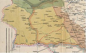
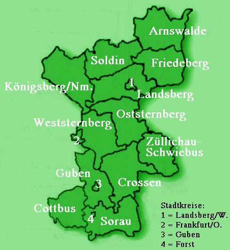
 Districts of the Neumark in 1818
After the declaration of the Kingdom of Prussia in 1701, the situation in the Neumark began to improve. King Frederick I initiated new waves of colonization. Many French Hugenots, forced to flee from religious persecution in France, arrived as settlers. The textile industry also began to develop in the Neumark. The Seven Years' War caused the region to regress in its development, as high contributions were exacted from the population for the war effort and the Neumark was the setting for battles such as at Kunersdorf. Under Frederick II, increased land reclamation and economic consolidation resulted from the drainage of the Warta and Notec areas.
The reorganization of Prussia after the territorial changes — resulting from the Congress of Vienna in 1815 — changed the political makeup of the Neumark. The districts of Dramburg and Schivelbein and the northern part of Landkreis Arnswalde with the town of Nörenberg became part of the Province of Pomerania. The Neumark's remaining territory was incorporated into the newly created Regierungsbezirk Frankfurt an der Oder of the Province of Brandenburg.
Germany
With the formation of the Prussian-led German Empire in 1871 the Neumark — along with the rest of Brandenburg — became part of a unified German state. In the Weimar Republic's National Assembly of 1 November 1919, the majority of the region voted for the Social Democratic Party of Germany (SPD). The Neumark populace mostly voted for the German National People's Party in the elections for the German Reichstag on 20 May 1928, with a small island of SPD voters. In the Reichstag vote of December 1924 1,900 votes were cast for the Polish People's Party out of a population of 570,000. In 1925 the Neumark had 3,500 Polish-speakers.[6] In the Reichstag vote of 6 November 1932, the Nazi Party won the election in the region.[7]
When the Nazi authorities dissolved the province of Posen-West Prussia in 1938, they expanded the Neumark to include the districts of Schwerin (now Skwierzyna) and Meseritz (now Międzyrzecz), although the districts of Arnswalde and Friedeberg were reassigned to Pomerania. According to the 1939 census, the Neumark had a population of 645,000 residents, including 3,000 non-Germans.[6] The dialect spoken in much of the territory was Neumärkisch, a variation of the East Low German Brandenburgisch dialect.
Infrastructure before 1945
The Neumark region long featured agriculture and forestry. The medium-sized towns were mostly Ackerbürgerstädte, or farmer-citizen-towns. The textile industry became prominent in the 19th century. With the construction of modern roadways, of the Fernverkehrstraße 1 (an arterial road from Berlin to Königsberg), and of the Prussian Eastern Railway, the Neumark also began to develop industrially. Such development was primarily geared toward agricultural needs and was concentrated near the cities of Landsberg and Küstrin, and the Neumark did not become nearly as industrialized or densely-populated as other German areas such as the Ruhr, Saxony, or Upper Silesia.
World War II
Near the end of World War II, the Soviet Red Army reached the Neumark at the end of January 1945. Because the Red Army had advanced so quickly, the civilian population of the region suffered greatly from warfare and occupying troops because they had not prepared to flee in time. More than 40,000 Neumarkers were killed in action as soldiers.
As the Neumark lay east of the Oder-Neisse line which formed the new border between Allied-controlled Germany and Poland, the region was put under Polish administration after the Potsdam Conference and eventually became part of Poland; see Recovered Territories. Germans remaining in the region were expelled and their land and possessions confiscated in accordance with the Polish government's Bierut Decree of March 1946. A small part of the German population, mostly technicians for the water supply companies, were retained and used for compulsory labour; they were allowed to emigrate to Germany in the 1950s. Older estimates indicated that of the pre-war population of 645,000, only 5,000 of the inhabitants from 1939 remained in the province in 1950.[7][8] According to the Centre Against Expulsions, 40,000 Neumarkers were killed in action as soldiers, 395,000 fled to West or East Germany by 1950, and 208,000 died, disappeared, or were murdered during the course of flight or expulsion by Polish and Soviet troops.[6]
Poland
The Oder-Neisse line delimiting Germany and Poland split several localities of the region into divided cities:
- Küstrin was separated into German Küstrin-Kietz and Polish Kostrzyn nad Odrą,
- Frankfurt an der Oder was split into German Frankfurt (Oder) and Polish Słubice,
- Guben was divided into German Guben and Polish Gubin,
- Bad Muskau was split into German Bad Muskau and Polish Łęknica,
- Forst was divided into German Forst and Polish Zasieki,
- Görlitz was separated into German Görlitz and Polish Zgorzelec.
To replace the expelled indigenous German population, the new Polish authorities re-settled the former Neumark, with about 66% of the new population Poles from central Poland and about 33% of the Poles and Ukrainians from territories of Poland annexed by the Soviet Union. From 1975–98 the former Neumark territory was divided between the Voivodeships of Gorzów and Zielona Góra with a small section around Chojna in Szczecin Voivodeship. Since the reorganization of Polish voivodeships on 1 January 1999, almost all of the former Neumark region lies within the Lubusz Voivodeship.
Notes
- This article incorporates information from the revision as of 12 May 2006 of the equivalent article on the German Wikipedia.
- ^ Poland.gov. "Mieszko I and Boleslaw Chrobry (Boleslaus the Brave)". Accessed December 3, 2006.
- ^ Barraclough, Geoffrey. The Origins of Modern Germany. W.W. Norton. 1984. ISBN 0-393-30153-2
- ^ a b Koch, H.W. A History of Prussia. Barnes & Noble Books, 1993. ISBN 0-88029-158-3
- ^ Urban, William. The Teutonic Knights. Greenhill Books. 2003. ISBN 1-85367-535-0
- ^ Eulenburg, Herbert, translated by M.M.Bozman. The Hohenzollerns. The Century Co. 1929.
- ^ a b c Zentrum gegen Vertreibungen. History of the German expellees and their homelands. Accessed 12 May 2006.
- ^ a b Westermanns Atlas zur Weltgeschichte. Georg Westermann Verlag. 1963.
- ^ Scheuch, Manfred. Historischer Atlas Deutschland: Vom Frankenreich bis zur Wiedervereinigung. Bechtermünz Verlag. 2001. ISBN 3-8289-0358-4
See also
External links
Categories:- States and territories established in 1252
- States and territories disestablished in 1945
- Former principalities
- Former countries in Europe
- States of the Holy Roman Empire
- States and territories established in 1535
- States and territories disestablished in 1571
- History of Brandenburg
- Lubusz Voivodeship

Wikimedia Foundation. 2010.