- Gubin, Poland
Infobox Settlement
name = Gubin
imagesize = 250px
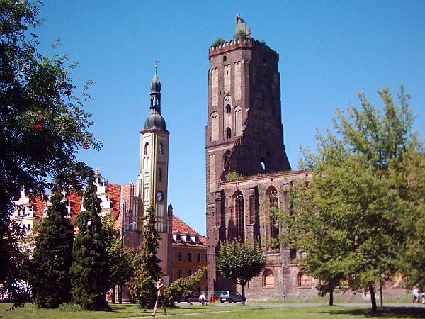
image_caption = Church ruins and town hall

image_shield = POL Gubin COA.svg
pushpin_
pushpin_label_position = bottom
subdivision_type = Country
subdivision_name = POL
subdivision_type1 = Voivodeship
subdivision_name1 = Lubusz
subdivision_type2 = County
subdivision_name2 = Krosno Odrzańskie
subdivision_type3 =Gmina
subdivision_name3 = Gubin (urban gmina)
leader_title = Mayor
leader_name = Bartłomiej Bartczak
established_title = Established
established_date =13th century
established_title3 = Town rights
established_date3 = 1235
area_total_km2 = 20.68
population_as_of = 2006
population_total = 16974
population_density_km2 = auto
timezone = CET
utc_offset = +1
timezone_DST = CEST
utc_offset_DST = +2
latd = 51 | latm = 57 | lats = | latNS = N | longd = 14 | longm = 43 | longs = | longEW = E
postal_code_type = Postal code
postal_code = 66-620
area_code = +48 68
blank_name = Car plates
blank_info = FKR
website = http://www.gubin.pl Gubin [IPA-pl|'|g|u|b|i|n] is atown inKrosno Odrzańskie County , southwesternPoland . Located on the right bank of theLusatian Neisse River, it has a population of 15,000 inhabitants (2005). Part of theZielona Góra Voivodeship from 1975 to 1998, it is now part of theLubusz Voivodeship . The Polish-German rail and road border crossings are connected with the German city ofGuben , of which Gubin was the eastern part until 1945.History
Prior to 1945, Gubin was part of
Guben in Germany. In 1945 theOder-Neisse line was chosen as the new German-Polish border at thePotsdam Conference . This meant that Guben would be split between the two countries, with the eastern portion of the city, including the historic centre, becoming Polish Gubin.The central part of Gubin was seriously damaged at the end of
World War II , with the historic town hall and church being burnt out. While the town hall has since been restored, the parish church is today a stabilised ruin.A large army garrison was based in Gubin from 1951-2002, including the 5th Infantry Division, which evolved into the 5th Saxon Tank Division in
1956 . The garrison was closed in 2002 following restructuring.Traffic
Gubin lies on the no. 32 road that works as an orbital road for Gubin, which starts at the border crossing with
Guben toKrosno Odrzańskie andZielona Góra and comes to the no. 5 road that links toPoznań . Gubin has also a railway border crossing.Land Structure
Gubin has a land mass of 20.68 km² of which 61% is used for agricultural purposes and 5% is used for forest uses.
The city takes up 1.49% of the area of the
Krosno Odrzańskie County Education
In Gubin, all of the schools to date are state-run by the Ministry of Education in Poland.
External links
* [http://www.gubin.pl Official website]


Wikimedia Foundation. 2010.