- Choszczno
-
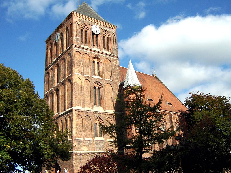
Choszczno St. Mary's church in Choszczno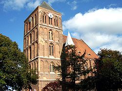
Flag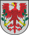
Coat of arms
 Choszczno
Coordinates: 53°10′N 15°24′E / 53.167°N 15.4°E Country  Poland
Voivodeship West Pomeranian County Choszczno County Gmina Gmina Choszczno Town rights 1284 Government - Mayor Robert Adamczyk Area - Total 9.58 km2 (3.7 sq mi) Population (2006) - Total 15,753 - Density 1,644.4/km2 (4,258.9/sq mi) Time zone CET (UTC+1) - Summer (DST) CEST (UTC+2) Postal code 73-200, 73-201 Area code(s) +48 95 Car plates ZCH Website http://www.choszczno.pl/ Choszczno [ˈxɔʂt͡ʂnɔ] (
 listen) (German: Arnswalde) is a town (population around 16.173) in West Pomeranian Voivodeship, Poland. The town is located in a marshy district between the river Stobnica (German: Stüdnitz) and Klukom lake (German: Klückensee), 32 km (20 mi) southwest of Stargard Szczeciński and on the main railway line between Szczecin and Poznań. Besides the Gothic church, there are a number of historical buildings from the 19th century industrial period namely, a gasification plant and a water pressure tower which dominates the town's skyline.
Choszczno is the administrative centre of Choszczno County.
The town was badly affected by the Second World War: 80% of its buildings were damaged or destroyed. The town was rebuilt and is now a center for local government of the Choszczno commune (Polish: gmina). Due to its microclimate the town has become a rehabilitation center for convalescing patients. The close proximity of the lakes has made it a tourist destination for water sports. Other tourist attractions are 'Wodny Raj' aqua park and Drawieński National Park, located 20 km (12 mi) to the east near the town of Drawno.
Choszczno has a strong military tradition and is the home base for the 2nd Artillery Regiment which is part of the 12th Mechanised Division headquartered in Szczecin.
The town's industries include: machinery, and the manufacture of clothing, animal feeds and starch.
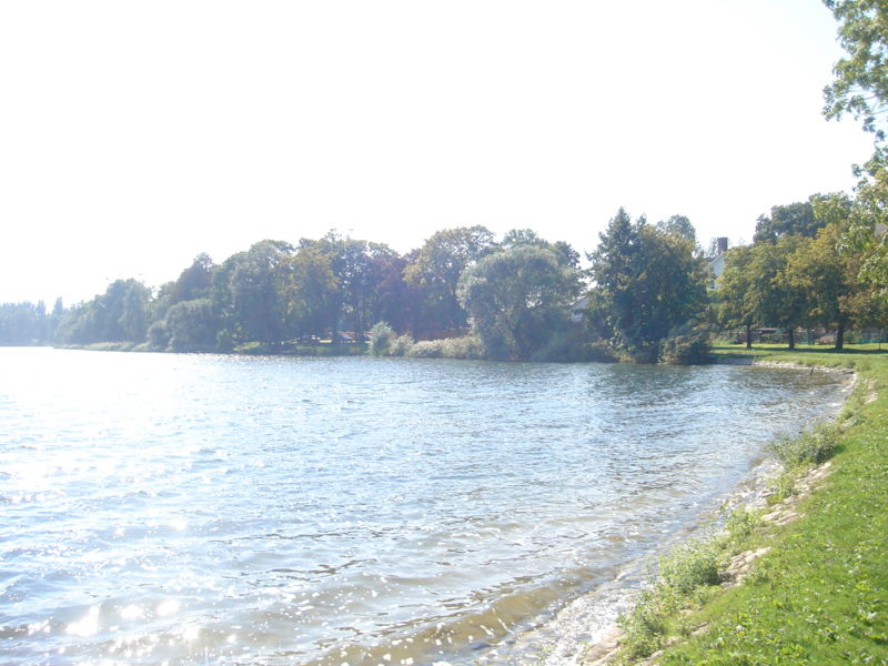
 Lake Klukom (German: Klückensee)
Contents
History
Arnswalde was since its foundation in the 13th century situated initially in Brandenburg and Kingdom of Prussia until 1938, when due to its close proximity to the new Polish border, it was added to the German border region Grenzmark Posen-West Prussia in the Province of Pomerania until 1945.
The name Arnswalde was first mentioned in the written chronicles in 1269.[1] The Cistercian Order gave up the lands around Arnswalde (Choszczno) probably in 1283. The Margrave of Brandenburg founded the town of Arnswalde at its present location. The Brandenburg red eagle coat of arms attests to Arnswalde's Brandenburg history. In 1289 Arnswalde is described as a town. In 1402 the town become a center of central European politics when the Brandenburg Neumark (New March) signed a vassal treaty with the Teutonic Order. The Teutonic Order's influence in the region lasted for 50 years. As the town was on the side of the Teutonic Order in the war with Poland it was invaded and pillaged by the Polish side a number of times.
Due to the nature of the Teutonic Order's policies towards its vassals the citizens of Arnswalde rebelled in 1443 and were finally successful in gaining special privileges in 1445. The town got stronger economically due its location, becoming a regional market town. Its strategic importance as a crossing of two tracks - from Stettin to Posen (Szczecin to Poznań) and from Landsberg towards Thorn (Gorzów Wielkopolski towards Toruń), was recognised and the city was fortified. This did not help as the town was ravaged by the 30 years war from 1618 to 1648.
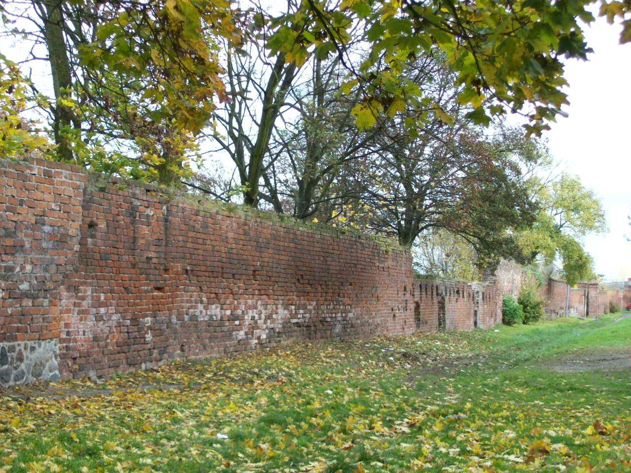
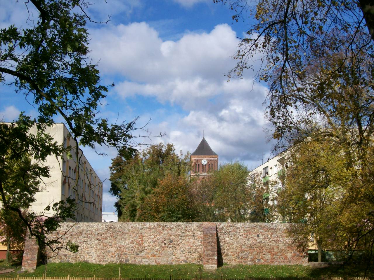
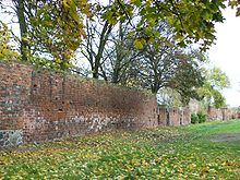 Mediaeval town wall
 Mediaeval town wall with St. Mary's church in the background
Stability occurred once Arnswalde become part of the Kingdom of Prussia, and to signify its importance a permanent garrison was stationed in the town from 1719. In this period the town advanced economically and socially with the establishment of a new postal route to Stargard. The 18th century again brought difficulties and the town experienced a number of tragedies caused by the plague, the worst one occurred in 1800 when 65 children perished.
19th century was a great time for the development of Arnswalde.[1] It was linked by railway with Stettin and Posen (Szczecin and Poznań) in 1848 and later with Berlin, also in the Brandenburg region. Since now mass public transportation could be realized at lower costs, a new tourist industry was established in the town. The microclimate in the region drew in weekend tourists from as far as Berlin and Brandenburg whilst the new hospital next to the lake catered for convalescing patients. The railway was also a catalyst for the local manufacturing industry as it provided an affordable transport of goods to the Port of Stettin (Szczecin), because of this a brewery and a textile industry flourished.
In 1905 a new hospital was opened and was situated on the bank of lake Klückensee (since 1945 called Lake Klukom). The First World War had little effect on Arnswalde but the post-war German depression damaged the tourist economy. In the framework of the demilitarisation of post-war Germany the garrison was disbanded, but in 1938 it was reinstated.
In 1939, short after the beginning of Second World War, the prisoner of war camp Oflag II B was established on the outskirt of the town. At the beginning, the majority of the prisoners were Polish and French. With the collapse of the German eastern front throughout the Red Army Vistula-Oder Offensive of 1945, Arnswalde was on the front line. Because of the town's strategic position of protecting Stargard and Stettin (Szczecin) seaport, a strong German garrison had been concentrated within the town to defend it. During the Russian offensive bitter fighting occurred, which resulted in almost 80% damage of the towns infrastructure. After the German resistance stopped in spring of 1945, Arnswalde was handed over to the Poles for administration as a part of the so-called Recovered Territories (when in fact it had been a German-speaking city since its foundation) and renamed Choszczno.
The German inhabitants, who composed almost 99% of the town population, either fled westwards or were expelled, usually forcibly, by the new local Polish administration. The town was mainly repopulated by Polish immigrants from the Polish territories now part of Lithuania, Belarus, and Ukraine - the so-called Kresy, lands eastern to the Curzon Line which Poland lost as a result of World War II to the USSR at the Yalta Conference and the agreements between the USSR, United Kingdom, and the USA. Authorised by the allied powers, this expulsion from the Soviet Union was called repatriation by Poland's new Communist government. Poles born in the Kresy, who refused to accept a new nationality, were deported to German lands (Recovered Territories) and told they had returned to their Motherland.
After 1945
The first Polish institution to send its representatives to the "recovered" town was the Polish Railways (PKP). In 1946 the first Polish education institution the "Bolesław Krzywousty" high school was opened. Due to the damage sustained by the town, the majority of the burnt out buildings were dismantled and the reclaimed bricks were sent for the rebuilding of Warsaw. This short-sighted policy of 'cannibalisation' was created by the unknown legal status of the newly acquired territories. Only after 1956, when the territory situation seemed to be clarified, the process of rebuilding started properly and investment by the Polish government begun. Due to the population growth the local government invested in new housing, and in 1959 the first newly built housing block was completed. The rebuilding continued and the majority of the architecture is now post 1950s. In 1990s the local government started investing in sporting facilities (an indoor swimming pool, sports arena, tennis courts) to promote active tourism.
Starting with its partnership with Fürstenwalde in 1978, the local government has been active in fostering foreign co-operation and the creation of links with different sister cities.
In 1984 Choszczno celebrated 700 years since its foundation. The traditional annual Days of Choszczno festival is held during the first weekend of June.
Population numbers in years
- 1750: 1.910[1]
- 1850: 2.440[1]
- 1850: 5.450 (in 1953: 11 Catholics, 89 Jews)[1]
- 1875: 6.853
- 1880: 7.358
- 1890: 7.507 (97 Cath., 191 Jews)
- 1925: 10.911 (10.450 Protestants, 300 Cath., 11 others, 97 Jews)
- 1933: 11.786 (11.268 Protestants, 303 Cath., 3 others, 121 Jews)
- 1939: 12.725 (11.943 Protestants, 465 Cath., 99 others, 12 Jews)[2]
Notable residents
- Wilhelm Fliess (1858-1928), otolaryngologist
- Mortimer von Kessel (1893–1981), general
- Robert Ferdinand Wilms (1824–1880), surgeon
International relations
Twin towns — sister cities
Choszczno is twinned with:
 Alytus, Lithuania
 Wolvega, Netherlands
 Fürstenwalde, Germany
 Spišská Belá, Slovakia
- Wunstorf, Germany
External links
References
- ^ a b c d e Heinrich Berghaus: Landbuch der Mark Brandenburg und des Markgrafenthums Nieder-Lausitz in der Mitte des 19. Jahrhunderts. Volume 3, Brandenburg 1864, pp. 486-491 (online, in German).
- ^ verwaltungsgeschichte.de
 This article incorporates text from a publication now in the public domain: Chisholm, Hugh, ed (1911). Encyclopædia Britannica (11th ed.). Cambridge University Press.
- Based on information on this page of the Choszczno website
Coordinates: 53°10′N 15°25′E / 53.167°N 15.417°E
Seat: Choszczno Urban-rural gminas 
Rural gminas Town and seat Choszczno
Villages Baczyn • Bonin • Brzostno • Chełpa • Czernice • Czyżewka • Gleźno • Golcza • Gostyczyn • Kleszczewo • Kołki • Koplin • Korytowo • Krzowiec • Łaszewo • Nowe Żeńsko • Oraczewice • Pakość • Piasecznik • Płoki • Przywodzie • Radaczewo • Radlice • Raduń • Roztocze • Rudniki • Rudnisko • Rzecko • Rzeczki • Skrzypiec • Sławęcin • Smoleń • Stary Klukom • Stawin • Stradzewo • Sulechówek • Sulino • Suliszewo • Sułowo • Szczepanka • Wardyń • Witoszyn • Wysokie • Zamęcin • Zwierzyn • ZwierzynekGeography of Pomerania Regions CurrentVorpommern (Western or Hither Pomerania) · Zachodniopomorskie · Pomerelia (Kashubia) · Pomerania euroregionAdministration Towns ListsList of towns in Vorpommern · List of towns in Farther Pomerania · Pomeranian cities, towns and villages · List of placenames in the Province of Pomerania (A-H · I-P · Q-Z)Largest>100,000>50,000Islands Peninsulae Rivers Lakes Bays, lagoons National parks Categories:- Cities and towns in West Pomeranian Voivodeship
- Choszczno County


Wikimedia Foundation. 2010.