- Cubert
-
For the Futurama character, see Cubert Farnsworth.
Coordinates: 50°22′44″N 5°07′00″W / 50.3789°N 5.1166°W
Cubert Cornish: Lannowynn 
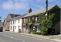
Cottages and pub of Cubert
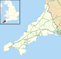
 Cubert shown within Cornwall
Population 1,155 (Civil Parish, 2001) OS grid reference SW785579 Parish Cubert Unitary authority Cornwall Ceremonial county Cornwall Region South West Country England Sovereign state United Kingdom Post town NEWQUAY Postcode district TR8 Dialling code 01637 Police Devon and Cornwall Fire Cornwall Ambulance South Western EU Parliament South West England UK Parliament Truro and Falmouth List of places: UK • England • Cornwall Cubert (Cornish: Lannowynn) is a civil parish and village in Cornwall, United Kingdom. It is situated three miles south-southwest of Newquay[1].
Once known as St Cubert, the village is dominated by the spire of its 14th century church which was enlarged by the addition of a south aisle a century later.
The village is named after the Welsh missionary St Cubert who, as a companion of St Carantoc, brought the Christian faith to this part of Cornwall, and to whom the church is dedicated. Unlike his companion St Carantoc—who travelled on to Brittany--St Cubert returned to Wales becoming abbot of his monastery and, according to the Welsh chronicles, dying in 775.
Contents
History and antiquities
The village has been without its prefix 'St' since the 16th/17th century when it was abandoned at the same time as the churchwardens whitewashed over the figure of St Cubert dressed as an abbot on the inside wall of the church. On early maps it often appears as St Kibberd—possibly indicating what the visiting cartographer heard when a local inhabitant was asked the name of the village.
To the west of the village, half way between the village and the coast, is the medieval Holy Well dedicated to St Cubert, from which the coastal bay takes its name. At the north end of the beach, only accessible two hours before and after low-tide, is a natural well in the rock that 19th century romanticists like to think was the origin of the name Holywell.
A mile to the east of the village near the Newquay crossroads, where the four parishes of St Cubert, Crantock, St Newlyn East and Perranzabuloe meet, was the chapel of St Nectan (the foundations of which were uncovered when the road was widened and straightened in 1970), where on certain feasts during the year the relics of the Patron Saints of the four parishes were carried in procession for their veneration by the faithful.
An inscribed stone, dated from the sixth to eighth centuries, was found imbedded in the walls of the fifteenth-century church. It bears the name of "Cenet[o]cus, son of Tege[r]nomalus".[2]
Gallery
References
- ^ Ordnance Survey: Landranger map sheet 200 Newquay & Bodmin ISBN 9780319229385
- ^ See the discussion and bibliography in Elisabeth Okasha, Corpus of early Christian inscribed stones of South-west Britain (Leicester: University Press, 1993), pp. 97-99.
External links
Geography of Cornwall Cornwall Portal Unitary authorities Major settlements Bodmin • Bude • Callington • Camborne • Camelford • Falmouth • Fowey • Hayle • Helston • Launceston • Liskeard • Looe • Lostwithiel • Marazion • Newlyn • Newquay • Padstow • Par • Penryn • Penzance • Porthleven • Redruth • Saltash • St Austell • St Blazey • St Columb Major • St Ives • St Just-in-Penwith • St Mawes • Stratton • Torpoint • Truro • Wadebridge
See also: Civil parishes in CornwallRivers Topics History • Status debate • Flag • Culture • Places • People • The Duchy • Diocese • Politics • Hundreds/shires • Places of interest • full list...Civil parishes of Truro and Falmouth constituency  Chacewater • Cubert • Cuby • Falmouth • Feock • Gerrans • Gwennap • Kea • Kenwyn • Ladock • Mylor • Penryn • Perranarworthal • Perranzabuloe • Philleigh • Probus • Ruan Lanihorne • St Agnes • St Allen • St Clement • St Erme • St Just in Roseland • St Michael Penkevil • St Newlyn East • Tregony • Truro • Veryan
Cornwall Portal Categories:- Villages in Cornwall
- Civil parishes in Cornwall
Wikimedia Foundation. 2010.


