- Mylor, Cornwall
-
For the village of the same name in Australia, see Mylor, South Australia.
Coordinates: 50°10′45″N 5°04′24″W / 50.17921°N 5.07328°W
Mylor (Cornish: Lannwydhek) is a civil parish in Cornwall, United Kingdom. It is situated approximately five miles north of Falmouth.[1]
The church town of the ecclesiastical parish is Mylor Churchtown: however, Mylor Bridge is the largest village in the parish.[1][2] Other settlements include Angarrick, Carclew, Flushing and Restronguet Passage.[3]
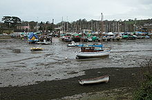
Mylor is a maritime parish and is bounded by water on three sides: Restronguet Creek to the north, Carrick Roads to the east and Falmouth Harbour to the south. To the west it is bounded by St Gluvias and Perranarworthal parishes[1][2].
The parish, named after Saint Melor, is in the Archdeaconry of Cornwall in the Diocese of Truro and the Deanery and Hundred of Kerrier. It was originally in Falmouth Registration District but is now in Truro Registration District.[3]
Contents
Church history
Mylor was in medieval times in the episcopal manor and peculiar deanery of Penryn and was also the mother church of Mabe. In 1277 there was a dispute between the Bishop of Exeter and the Earl of Cornwall over sand and soil which was being carried away from the glebe land of Mylor by agents of the Earl. In 1278 this was settled by the Bishop lifting the threat of excommunication he had made and redistributing the large sum of money he had collected as custom duty for the sand and soil. Bishop Peter Quinel gave the church and church land to the provostship of Glasney College in exchange for the deanery of Probus in 1288.[4]
Present day
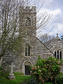
Main article: Mylor ChurchtownMylor Parish Church (Anglican) is in Mylor Churchtown and is dedicated to St Melorus. The present structure dates from a major reconstruction around 1870 but parts of the original church dated back to Norman times and the church still has a Norman north door.[2]
There were also Wesleyan Methodist and Primitive Methodist chapels in Mylor parish.[2]
Customs
A mummers play text which had, until recently, been attributed to Mylor (much quoted in early studies of folk plays, such as The Mummers Play by R. J. E. Tiddy – published posthumously in 1923 – and The English Folk-Play (1933) by E. K. Chambers) has now been shown, by genealogical and other research, to have originated in Truro, around 1780.[5][6]
Notable residents
- Edward Hoblyn, Vicar of Mylor for 45 years in the 19th century[7]
- The engineer William Husband was born here.
- Robert Terrill Rundle, the Wesleyan Methodist famous for his missionary work in Western Canada, was born in Mylor.
- Thomas Tregosse, Puritan minister, sometime Vicar of Mylor and Mabe
References
- ^ a b c Ordnance Survey: Landranger map sheet 204 Truro & Falmouth ISBN 9780319231494
- ^ a b c d GENUKI website; Mylor. Retrieved April 2010
- ^ a b Cornwall Council online mapping; Retrieved May 2010
- ^ Cornish Church Guide (1925) Truro: Blackford; pp. 168-69
- ^ The Truro cordwainers' play: a "new" eighteenth-century Christmas play — Research article at BNET.com
- ^ Truro (Formerly Mylor): "A Play for Christmas", 1780s (Full text and notes)
- ^ Brown, H. M. (1976) A Century for Cornwall. Truro: Blackford; pl. 2, f.p. 22 (picture of him in old age, dated 1866)
- Notes on the Parish of Mylor, published by Hugh Pengelly Olivey in 1907; Retrieved online April 2010
External links
Geography of Cornwall Cornwall Portal Unitary authorities Major settlements Bodmin • Bude • Callington • Camborne • Camelford • Falmouth • Fowey • Hayle • Helston • Launceston • Liskeard • Looe • Lostwithiel • Marazion • Newlyn • Newquay • Padstow • Par • Penryn • Penzance • Porthleven • Redruth • Saltash • St Austell • St Blazey • St Columb Major • St Ives • St Just-in-Penwith • St Mawes • Stratton • Torpoint • Truro • Wadebridge
See also: Civil parishes in CornwallRivers Topics History • Status debate • Flag • Culture • Places • People • The Duchy • Diocese • Politics • Hundreds/shires • Places of interest • full list...Civil parishes of Truro and Falmouth constituency  Chacewater • Cubert • Cuby • Falmouth • Feock • Gerrans • Gwennap • Kea • Kenwyn • Ladock • Mylor • Penryn • Perranarworthal • Perranzabuloe • Philleigh • Probus • Ruan Lanihorne • St Agnes • St Allen • St Clement • St Erme • St Just in Roseland • St Michael Penkevil • St Newlyn East • Tregony • Truro • Veryan
Cornwall Portal Categories:- Civil parishes in Cornwall
- Populated coastal places in Cornwall
Wikimedia Foundation. 2010.


