- Dallinghoo
-
Coordinates: 52°08′46″N 1°18′43″E / 52.146°N 1.312°E
Dallinghoo 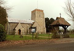
St. Mary's church, Dallinghoo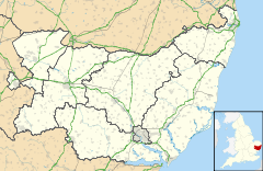
 Dallinghoo
Dallinghoo shown within SuffolkShire county Suffolk Region East Country England Sovereign state United Kingdom Postcode district IP13 0JP EU Parliament East of England List of places: UK • England • Suffolk Contents
Location
Dallinghoo is a village some 3 miles (4.5 km) north of Woodbridge, Suffolk, England. Formed from Church Road (west) and Pound Hill to the south and branches NE after the centre of the village.
Its church was originally a large building with a central tower but the chancel has since been destroyed. The Church also had connections with nearby Letheringham Abbey.
Dallinghoo is also the birthplace of Francis Light, founder of Penang in Malaysia and father of William Light who founded Adelaide in Australia.
Dallinghoo Village Hall (TM2654) is off Pound Hill a little north of the village.
The Oldest and most important house in Dallinghoo is Whitehouse Farm.
Dallinghoo Hall (TM2754) is 1 km SE from the village.
Press
Dallinghoo has featured in the press in 2009 after £500,000 worth of Iceni gold coins were found in a field.[1]
References
External links
 Media related to Dallinghoo at Wikimedia Commons
Towns Civil parishes Alderton · Aldringham cum Thorpe · Badingham · Bawdsey · Benhall · Blaxhall · Blythburgh · Boulge · Boyton · Bramfield · Brandeston · Bredfield · Brightwell · Bromeswell · Bruisyard · Bucklesham · Burgh · Butley · Campsea Ashe · Capel St Andrew · Charsfield · Chediston · Chillesford · Clopton · Cookley · Cransford · Cratfield · Cretingham · Culpho · Dallinghoo · Darsham · Debach · Dennington · Dunwich · Earl Soham · Easton · Eyke · Falkenham · Farnham · Foxhall · Framlingham · Friston · Gedgrave · Great Bealings · Great Glemham · Grundisburgh · Hacheston · Hasketon · Hemley · Heveningham · Hollesley · Hoo · Huntingfield · Iken · Kelsale cum Carlton · Kesgrave · Kettleburgh · Kirton · Knodishall · Letheringham · Levington · Linstead Magna · Linstead Parva · Little Bealings · Little Glemham · Marlesford · Martlesham · Melton · Middleton · Monewden · Nacton · Newbourne · Otley · Parham · Peasenhall · Pettistree · Playford · Purdis Farm · Ramsholt · Rendham · Rendlesham · Rushmere St Andrew · Saxtead · Shottisham · Sibton · Snape · Sternfield · Stratford St Andrew · Stratton Hall · Sudbourne · Sutton · Swefling · Swilland · Theberton · Thorington · Trimley St Martin · Trimley St Mary · Tuddenham St Martin · Tunstall · Ubbeston · Ufford · Walberswick · Waldringfield · Walpole · Wantisden · Wenhaston with Mells Hamlet · Westerfield · Westleton · Wickham Market · Witnesham · YoxfordOther settlements See also: Listed buildings · Local elections Categories:- Suffolk Coastal
- Villages in Suffolk
- Civil parishes in Suffolk
- Suffolk geography stubs


Wikimedia Foundation. 2010.