- Culpho
-
Coordinates: 52°05′46″N 1°13′30″E / 52.096°N 1.225°E
Culpho 
 Culpho
Culpho shown within SuffolkShire county Suffolk Region East Country England Sovereign state United Kingdom EU Parliament East of England List of places: UK • England • Suffolk 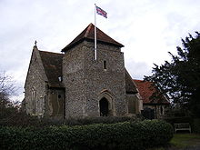 St. Butolph's Church, Culpho. Image author: Adrian Cable
Culpho (pronounced Cul-fo) is a hamlet of about 40 people standing just outside Grundisburgh, Suffolk, about four miles west of Woodbridge. Its nearest villages are Great Bealings and Playford. It is big enough to have its own church, St Botolphs, which is part of a shared benefice with Great Bealings, Little Bealings and Playford.
In 1280 an abbey was erected here[1] on behalf of the monks of Leiston Abbey but this has long been demolished and a farmhouse now stands in its place.
Culpho is one of the Thankful Villages - those very rare places that suffered no fatalities in the Great War of 1914 to 1918.
References
External links
 Media related to Culpho at Wikimedia Commons
Towns Civil parishes Alderton · Aldringham cum Thorpe · Badingham · Bawdsey · Benhall · Blaxhall · Blythburgh · Boulge · Boyton · Bramfield · Brandeston · Bredfield · Brightwell · Bromeswell · Bruisyard · Bucklesham · Burgh · Butley · Campsea Ashe · Capel St Andrew · Charsfield · Chediston · Chillesford · Clopton · Cookley · Cransford · Cratfield · Cretingham · Culpho · Dallinghoo · Darsham · Debach · Dennington · Dunwich · Earl Soham · Easton · Eyke · Falkenham · Farnham · Foxhall · Framlingham · Friston · Gedgrave · Great Bealings · Great Glemham · Grundisburgh · Hacheston · Hasketon · Hemley · Heveningham · Hollesley · Hoo · Huntingfield · Iken · Kelsale cum Carlton · Kesgrave · Kettleburgh · Kirton · Knodishall · Letheringham · Levington · Linstead Magna · Linstead Parva · Little Bealings · Little Glemham · Marlesford · Martlesham · Melton · Middleton · Monewden · Nacton · Newbourne · Otley · Parham · Peasenhall · Pettistree · Playford · Purdis Farm · Ramsholt · Rendham · Rendlesham · Rushmere St Andrew · Saxtead · Shottisham · Sibton · Snape · Sternfield · Stratford St Andrew · Stratton Hall · Sudbourne · Sutton · Swefling · Swilland · Theberton · Thorington · Trimley St Martin · Trimley St Mary · Tuddenham St Martin · Tunstall · Ubbeston · Ufford · Walberswick · Waldringfield · Walpole · Wantisden · Wenhaston with Mells Hamlet · Westerfield · Westleton · Wickham Market · Witnesham · YoxfordOther settlements See also: Listed buildings · Local electionsCategories:- Suffolk Coastal
- Villages in Suffolk
- Thankful Villages
- Civil parishes in Suffolk
- Suffolk geography stubs


Wikimedia Foundation. 2010.