- Melton, Suffolk
-
Coordinates: 52°06′00″N 1°19′59″E / 52.1°N 1.333°E
Melton, Suffolk 
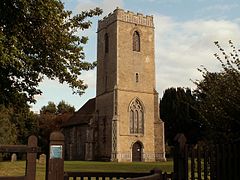
St. Andrew's, Melton old church
 Melton, Suffolk shown within Suffolk
Shire county Suffolk Region East Country England Sovereign state United Kingdom EU Parliament East of England List of places: UK • England • Suffolk Melton is a village in Suffolk, England, located approximately one mile north east of Woodbridge. The 2001 census recorded a population of 3718.[1] The village is served by Melton railway station on the Ipswich-Lowestoft East Suffolk Line.
Melton was covered in the Domesday Book. In 1774 a local Act established the Loes and Wilford Hundred Incorporation at Melton. The House of Industry (workhouse) operated until 1826. From 1826 the building became the Suffolk County Asylum for Pauper Lunatics. Much altered during the 19th and early 20th centuries, in 1916 the asylum became known as St Audry's Hospital, which was closed in 1993 (approx date).[2] The buildings have been converted into residential accommodation.
Melton was originally settled around the old church in the north east of Melton, later moving to Yarmouth Road, which is the old road between Great Yarmouth and London. The bestselling Victorian novelist Henry Seton Merriman died at Melton in 1903.
References
- ^ Parish website: Retrieved 21 December 2010.
- ^ "Suffolk County Asylum: St Audrey's Hospital". County Asylums. http://www.countyasylums.com/mentalasylums/staudrys01.htm. Retrieved 29 September 2009.
External links
 Media related to Melton, Suffolk at Wikimedia Commons
Towns Civil parishes Alderton · Aldringham cum Thorpe · Badingham · Bawdsey · Benhall · Blaxhall · Blythburgh · Boulge · Boyton · Bramfield · Brandeston · Bredfield · Brightwell · Bromeswell · Bruisyard · Bucklesham · Burgh · Butley · Campsea Ashe · Capel St Andrew · Charsfield · Chediston · Chillesford · Clopton · Cookley · Cransford · Cratfield · Cretingham · Culpho · Dallinghoo · Darsham · Debach · Dennington · Dunwich · Earl Soham · Easton · Eyke · Falkenham · Farnham · Foxhall · Framlingham · Friston · Gedgrave · Great Bealings · Great Glemham · Grundisburgh · Hacheston · Hasketon · Hemley · Heveningham · Hollesley · Hoo · Huntingfield · Iken · Kelsale cum Carlton · Kesgrave · Kettleburgh · Kirton · Knodishall · Letheringham · Levington · Linstead Magna · Linstead Parva · Little Bealings · Little Glemham · Marlesford · Martlesham · Melton · Middleton · Monewden · Nacton · Newbourne · Otley · Parham · Peasenhall · Pettistree · Playford · Purdis Farm · Ramsholt · Rendham · Rendlesham · Rushmere St Andrew · Saxtead · Shottisham · Sibton · Snape · Sternfield · Stratford St Andrew · Stratton Hall · Sudbourne · Sutton · Swefling · Swilland · Theberton · Thorington · Trimley St Martin · Trimley St Mary · Tuddenham St Martin · Tunstall · Ubbeston · Ufford · Walberswick · Waldringfield · Walpole · Wantisden · Wenhaston with Mells Hamlet · Westerfield · Westleton · Wickham Market · Witnesham · YoxfordOther settlements See also: Listed buildings · Local elections Categories:- Suffolk Coastal
- Villages in Suffolk
- Civil parishes in Suffolk
- Suffolk geography stubs
Wikimedia Foundation. 2010.

