- Debach
-
Debach is a small village about 4 miles northwest of Woodbridge, Suffolk, UK. At the time of the Domesday Book it was called Debenbeis or Debeis, Depebecs, Debec or Debes. The book lists the landowners there at that time as Count Alan, Roger Bigot - the Sheriff of Norfolk and Suffolk, and Sturstan son of Widdow and Roger de Poitou from him, The Bishop of Bayeux, William de Warenne, Geoffrey de Mandeville and Ranulph Peveril.
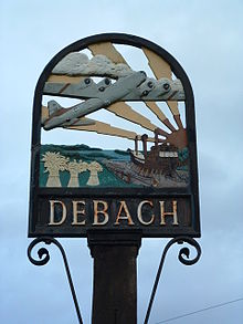 Debach village sign
The 2001 census recorded 30 households in the village with a total population of 75. The population was estimated to consist of 80 people in 2005. These figures were notably smaller than those recorded in 19th century censuses:- in 1801 the population of Debach was 117, in 1851 there was a total population of 113 in 25 households and in 1881 a total of 138 people lived there in 29 households with about 66% of those whose occupation was recorded being employed directly in agriculture. The population peaked at 140 in 1901 and 1911 and was still 127 in 1951 but fell dramatically by 1961 to 90.
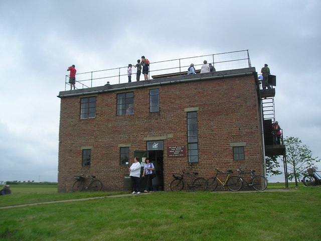
During World War II the village housed an airbase, RAF Debach, which was home to the 493rd BG(H) - Helton's Hellcats- USAAF. The airbase closed soon after the war and was used as a prisoner of war camp in 1945 for German prisoners but it is now the site of Debach Enterprises, although part of the runway has been preserved.
Debach is also home to the Green label food company, situated at Loomswood Farm, which specialises in the production of Gressingham Duck.
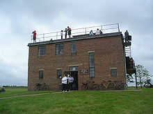 The Control Tower at Debach Airfield
Contents
All Saints' Parish Church
The former parish church of Debach dates back to the 13th century and was renovated in 1794 and then, not again until 1854-5 when it was almost completely rebuilt and enlarged by George Gilbert Scott at a cost of £1500, £400 of which was borrowed and only partially repaid which led to a local scandal and drove the aggrieved lender to publish a book in 1879 which was entitled How the Parish Of Debach Borrowed £400 And Refused To Pay It All Back. The small local population resulted in there being only a handful of worshippers at the church in the 1960s and it was deconsecrated in 1971 and the building was sold in 1979 to become a private residence. The 16th century bell was bought by St. Andrew's Church, Redlingfield in Suffolk [1] and the wooden stand-alone belfry rotted away. Gravestones were moved to the front garden area where the village war memorial is also situated. The church building has also had its stained glass removed and the carved stone font has been moved to the front garden area.[1][2]
Notable residents
The author Ronald Blythe wrote the book Akenfield while living in Debach in 1966-7 and mentions the village - "a tiny parish of some eighty souls" - in the preface to the book.
Debach was also the birthplace and home of Jimmy "Holy Jim" Knights (1882–1981), a singer of traditional East Anglian folk and music hall songs, whose renditions of such tunes were recorded by collectors of traditional music performances when he was more than 90 years old in the 1970s.
References
- ^ "Debach" suffolkchurches.co.uk
- ^ "A Room with a Pew" Telegraph
- "The Domesday Book Online"
- The Shell Guide to Suffolk Norman Scarfe. Shell UK 1976. ISBN 0-571-04901-X
- Akenfield Ronald Blythe. Penguin Books 1969. ISBN 978-0-141-18792.
- "Sing, Say or Pay Part 2"
External links
 Media related to Debach at Wikimedia Commons
Coordinates: 52°08′N 1°17′E / 52.133°N 1.283°E
Towns Civil parishes Alderton · Aldringham cum Thorpe · Badingham · Bawdsey · Benhall · Blaxhall · Blythburgh · Boulge · Boyton · Bramfield · Brandeston · Bredfield · Brightwell · Bromeswell · Bruisyard · Bucklesham · Burgh · Butley · Campsea Ashe · Capel St Andrew · Charsfield · Chediston · Chillesford · Clopton · Cookley · Cransford · Cratfield · Cretingham · Culpho · Dallinghoo · Darsham · Debach · Dennington · Dunwich · Earl Soham · Easton · Eyke · Falkenham · Farnham · Foxhall · Framlingham · Friston · Gedgrave · Great Bealings · Great Glemham · Grundisburgh · Hacheston · Hasketon · Hemley · Heveningham · Hollesley · Hoo · Huntingfield · Iken · Kelsale cum Carlton · Kesgrave · Kettleburgh · Kirton · Knodishall · Letheringham · Levington · Linstead Magna · Linstead Parva · Little Bealings · Little Glemham · Marlesford · Martlesham · Melton · Middleton · Monewden · Nacton · Newbourne · Otley · Parham · Peasenhall · Pettistree · Playford · Purdis Farm · Ramsholt · Rendham · Rendlesham · Rushmere St Andrew · Saxtead · Shottisham · Sibton · Snape · Sternfield · Stratford St Andrew · Stratton Hall · Sudbourne · Sutton · Swefling · Swilland · Theberton · Thorington · Trimley St Martin · Trimley St Mary · Tuddenham St Martin · Tunstall · Ubbeston · Ufford · Walberswick · Waldringfield · Walpole · Wantisden · Wenhaston with Mells Hamlet · Westerfield · Westleton · Wickham Market · Witnesham · YoxfordOther settlements See also: Listed buildings · Local elections Categories:- Suffolk Coastal
- Villages in Suffolk
- Civil parishes in Suffolk

Wikimedia Foundation. 2010.