- Darsham
-
Coordinates: 52°16′01″N 1°31′48″E / 52.267°N 1.53°E
Darsham 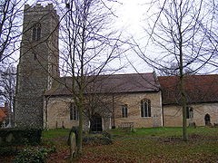
Church of All Saints, Darsham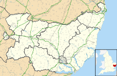
 Darsham
Darsham shown within SuffolkShire county Suffolk Region East Country England Sovereign state United Kingdom EU Parliament East of England List of places: UK • England • Suffolk Darsham is a village in Suffolk, England. It is located approximately 4 miles (6 km) north east of Saxmundham. The village is bypassed by the A12 and is served by Darsham railway station, which is approximately one mile away from the village centre, on the Ipswich-Lowestoft East Suffolk Line.
The name of the village of Darsham derives from Deores Ham — home of the deer. This name is borne out by early reference to local roadways as chaseways. There was hunting in this area as late as the 18th century. Darsham is a mixed community with six farms. The village still has a pub The Fox, however over the past few years the village has lost its school, shop and post office.
The garage on the A12, now primarily a petrol station, has a cafe and a shop. There is also a farm shop, a hand made tile factory, a pottery, a builder, an irrigation contractor, a plant nursery, seed and feed merchants, a national chain roadside-restaurant and a cafe. A private nursing home and a cycle hire business provide a service for those who require it.
Contents
History
The village gave its name to the Ham class minesweeper HMS Darsham.
In WW2, Darsham was the site of RAF High Street, situated just off the A144 road to Bramfield and Halesworth, an early radar station part of Chain Home which originated at Bawdsey Manor, in Suffolk.
The High Street radar station had "Type 1 radar", 4 (Receive towers) of 240 ft made from wood and five (Transmit towers) of 360 ft made of steel. The wood towers stood in a close formation.[1]
The site later became a fireworks factory, (postcode IP17 3QD).
Due to the threat of air-raids, children from the Palmer family from the nearby Park Farm, Thorington were evacated.
Darsham contains an 18th-century farmhouse called White House Farm, originally built in 1750, a fire caused a partial rebuild in 1825. White House Farm has been owned by several families throughout the ages including the Blacks, the Smiths, the Jones, and currently by the Newman family since 1996. A legend has it that, sometimes, a mysterious human figure named Mandy by the locals haunts the quiet village with scary dance routines, which are said to have been often performed during Christmas 2010. An inquiry has been brought into parliament in order to reinstate the tranquility of the disturbed inhabitants. Another sinister spirit is named window dweller after their nocturnal smoking by the stained glass window of the church of All Saints, which has been repeatedly noticed since the late 17th century. It is believed by the Darshamites that the figure is the same that had caused the Great Fire of London in 1666 before fleeing to the village.
Further down the A12 towards Lowestoft there are a row of cottages, Optney Cottages, that used to be the Darsham Coaching Inn - whose original name is unknown. The first two were where the beer was brewed, and they have cellars. They are placed next to Holly Tree Cottage bed and breakfast, which was originally two cottages, and has had various names, including Green Gables and The Hurdle Yard, because hurdles for farms were made in the outbuildings. Pictures still remain of the working yard in the 1950s.
References
External links
External links
 Media related to Darsham at Wikimedia Commons
Towns Civil parishes Alderton · Aldringham cum Thorpe · Badingham · Bawdsey · Benhall · Blaxhall · Blythburgh · Boulge · Boyton · Bramfield · Brandeston · Bredfield · Brightwell · Bromeswell · Bruisyard · Bucklesham · Burgh · Butley · Campsea Ashe · Capel St Andrew · Charsfield · Chediston · Chillesford · Clopton · Cookley · Cransford · Cratfield · Cretingham · Culpho · Dallinghoo · Darsham · Debach · Dennington · Dunwich · Earl Soham · Easton · Eyke · Falkenham · Farnham · Foxhall · Framlingham · Friston · Gedgrave · Great Bealings · Great Glemham · Grundisburgh · Hacheston · Hasketon · Hemley · Heveningham · Hollesley · Hoo · Huntingfield · Iken · Kelsale cum Carlton · Kesgrave · Kettleburgh · Kirton · Knodishall · Letheringham · Levington · Linstead Magna · Linstead Parva · Little Bealings · Little Glemham · Marlesford · Martlesham · Melton · Middleton · Monewden · Nacton · Newbourne · Otley · Parham · Peasenhall · Pettistree · Playford · Purdis Farm · Ramsholt · Rendham · Rendlesham · Rushmere St Andrew · Saxtead · Shottisham · Sibton · Snape · Sternfield · Stratford St Andrew · Stratton Hall · Sudbourne · Sutton · Swefling · Swilland · Theberton · Thorington · Trimley St Martin · Trimley St Mary · Tuddenham St Martin · Tunstall · Ubbeston · Ufford · Walberswick · Waldringfield · Walpole · Wantisden · Wenhaston with Mells Hamlet · Westerfield · Westleton · Wickham Market · Witnesham · YoxfordOther settlements See also: Listed buildings · Local electionsCategories:- Suffolk Coastal
- Villages in Suffolk
- Civil parishes in Suffolk


Wikimedia Foundation. 2010.