- Midori-ku, Yokohama
-
Midori
緑— Ward of Yokohama — 緑区• Midori-ku 
FlagLocation of Midori in Kanagawa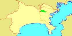

 Midori
Coordinates: 35°30′45″N 139°32′17″E / 35.5125°N 139.53806°ECoordinates: 35°30′45″N 139°32′17″E / 35.5125°N 139.53806°E Country Japan Region Kantō Prefecture Kanagawa City Yokohama Area - Total 25.42 km2 (9.8 sq mi) Population (February 2010) - Total 176,038 - Density 6,900/km2 (17,870.9/sq mi) Time zone Japan Standard Time (UTC+9) City Symbols - Tree Maple - Flower Bletilla striata Address 118 Terayama-chō, Midori-ku Yokohama-shi, Kanagawa-ken
226-0013Website Official website of Midori-ku 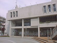 Midori Ward Office
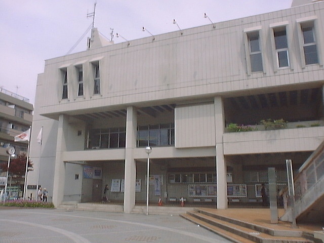
Midori-ku (緑区) is one of the 18 wards of the city of Yokohama in Kanagawa Prefecture, Japan. As of 2010, the ward had an estimated population of 176,038 and a density of 6,900 persons per km². The total area was 25.42 km².
Contents
Geography
Midori Ward is located in eastern Kanagawa Prefecture, and on the northwest borders of the city of Yokohama. Except for the northeast portion, much of the area is hilly and relatively sparsely populated compared to other parts of the city. The flatter northeast portion is located on the Tsurumi River basin, with the river serving as a ward boundary with Tsuzuki-ku.
Surrounding municipalities
History
The area around present-day Midori Ward was formerly part of Tsuzuki District in Musashi Province. During the Edo period, it was a rural region classified as tenryō territory controlled directly by the Tokugawa shogunate, but administered through various hatamoto. After the Meiji Restoration, the area became part of the new Kanagawa Prefecture in 1868. In the cadastral reform of April 1, 1889, the area was divided into numerous villages. During the Meiji period, the area was a center for sericulture. On April 1, 1939, Tsuzuki District was annexed by the neighboring city of Yokohama. In a major administrative reorganization of October 1, 1969, Midori emerged as an independent ward within the city of Yokohama. In 1980, a portion of Midori Ward was transferred to Seya Ward. In 1994, Midori-ku was divided into the present-dau Midori-ku, and Aoba-ku and Tsuzuki-ku.
Economy
Midori Ward is largely a regional commercial center and bedroom community for central Yokohama and Tokyo. There is some residual agriculture in Midori Ward, primarily rice. Major industries include food processing, electronics and precision manufacturing.
Transportation
Railroads
- JR East – Yokohama Line
- Kamoi - Nakayama - Tōkaichiba - Nagatsuta
- Tokyu Corporation – Tōkyū Den-en-toshi Line, Kodomonokuni Line
- Yokohama City Transportation Bureau - Green Line
Highways
Prefecture roads
- Kanagawa Prefectural Route 109
- Kanagawa Prefectural Route 139
- Kanagawa Prefectural Route 140
Education
Several universities are located in the ward, most notably the Nagatsuta campus of the Tokyo Institute of Technology. Other universities include Showa University and Toyo Eiwa University.
Noted people from Midori Ward
- Masahiro Inoue, actor
Neigborhoods with Midori Ward
Areas with a -cho suffix are located in the less dense parts of the ward.
- Aoto-cho (青砥町)
- Daimura-cho (台村町)
- Hakusan (白山)
- Higashihongo (東本郷)
- Higashihongo-cho (東本郷町)
- Ibukino (いぶき野)
- Kamiyama (上山)
- Kamoi (鴨居)
- Kamoi-cho (鴨居町)
- Kirigaoka (霧が丘)
- Kitahassaku-cho (北八朔町)
- Koyama-cho (小山町)
- Miho-cho (三保町)
- Morinodai (森の台)
- Nagatsuta (長津田)
- Nagatsuta-cho (長津田町)
- Nagatsuta-minamidai (長津田みなみ台)
- Nakayama-cho (中山町)
- Niiharu-cho (新治町)
- Nishihassaku-cho (西八朔町)
- Takeyama (竹山)
- Terayama-cho (竹山町)
- Tokaichiba-cho (十日市場町)
References
- Kato, Yuzo. Yokohama Past and Present. Yokohama City University (1990).
External links
 Kanagawa Prefecture
Yokohama (capital city) 
Kawasaki Sagamihara Other cities Aikō District Ashigarakami District Ashigarashimo District Kōza District Miura District Naka District Other areas Categories:- Wards of Yokohama
- JR East – Yokohama Line


Wikimedia Foundation. 2010.