- Ōiso, Kanagawa
-
Ōiso
大磯町— Town — Location of Ōiso in Kanagawa Prefecture Coordinates: 35°18′31″N 139°18′46″E / 35.30861°N 139.31278°ECoordinates: 35°18′31″N 139°18′46″E / 35.30861°N 139.31278°E Country Japan Region Kantō Prefecture Kanagawa Prefecture District Naka District Area – Total 17.18 km2 (6.6 sq mi) Population (February 1, 2010) – Total 32,725 – Density 1,910/km2 (4,946.9/sq mi) Time zone Japan Standard Time (UTC+9) City Symbols - Tree Japanese Black Pine & Camellia sasanqua - Flower Calystegia soldanella - Bird Common Gull Phone number 0463-61-4100 Address 183 Ōiso, Ōiso-machi, Naka-gun, Kanagawa-ken
255-8555Website Town of Ōiso Ōiso (大磯町 Ōiso-machi) is a town located in Naka District, Kanagawa Prefecture, Japan. As of 2010, the town had an estimated population of 32,725 and a density of 1,910 persons per km². The total area was 17.18 km².
Contents
Geography
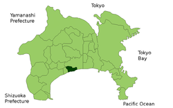
Ōiso is located on the coastline of central Kanagawa Prefecture, facing Sagami Bay of the Pacific Ocean. The area is generally hilly, rising to 168-meter Mount Koma in the northwest of the center of town. The area has a temperate maritime climate with short, cool winters and hot, humid summers. The coastline of Ōiso is sandy, and is regarded as the western end of the Shōnan area and remains a popular beach resort and vacation spot for residents of Tokyo.
Surrounding unicipalities
History
Ōiso is the ancient center of Sagami Province. The exact location of the Nara period provincial government of Sagami Province is unknown, but tradition and the place name "Kōzu" place its probable location to within the boundaries of present-day Ōiso.
As a minor coastal settlement, Ōiso was under the control of the late Hōjō clan of Odawara during the Sengoku period. In the Edo period, it was nominally part of Odawara Domain, and developed as Ōiso-juku, a post town on the Tōkaidō connecting Edo with Kyoto. After the Meiji Restoration and with the establishment of the district system in 1878, it came under the control of Yurugi District (淘綾郡 Yurugi-gun). Ōiso became a town on April 1, 1889. Blessed with a temperate climate, and with convenient access to Tokyo due to the Tōkaidō Main Line railway, it was favored as a seaside health resort by politicians and literary figures during the Meiji period after a glowing report on its location was written by noted physician Matsumoto Jun. Prime Minister Itō Hirobumi, Yamagata Aritomo, Saionji Kinmochi and Ōkuma Shigenobu, Foreign Minister Mutsu Munemitsu, writer Shimazaki Toson and zaibatsu founder Yasuda Zenjirō had summer residences in Ōiso. This popularity continued into the postwar era, and Prime Minister Shigeru Yoshida also had a residence in Ōiso to which he retired after leaving politics. The former Itō, Yoshida and Shimazaki residences have been preserved as memorial museums.
Ōiso merged with neighboring Kōzu Town on December 1, 1954.
Transportation
Railway
Highway
- National Route 1
- Japan National Route 134
- Odawara-Atsugi Road
- Seishō Bypass
Sister city relations
 - Komoro, Nagano, since September, 1968
 - Yamaguchi, Nagano, since April, 1973
 - Racine, Wisconsin, USA
 - Dayton, Ohio, USA
Noted people from Ōiso
- Tatsuo Satō - Director
- Eijiro Ozaki - actor
External links
 Kanagawa Prefecture
Yokohama (capital city) Wards 
Kawasaki Wards Sagamihara Wards Other cities Aikō District Ashigarakami District Ashigarashimo District Kōza District Miura District Naka District - Ninomiya
- Ōiso
Other areas - Official website in Japanese (some content in English)

This Kanagawa Prefecture location article is a stub. You can help Wikipedia by expanding it.


