- New York State Route 64
-
This article is about the current alignment of NY 64. For the former alignment of NY 64 in Delaware County, see New York State Route 64 (1920s–1930).
NYS Route 64
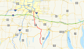
Map of the Finger Lakes region with NY 64 highlighted in redRoute information Maintained by NYSDOT Length: 31.06 mi[2] (49.99 km) Existed: 1930[1] – present Major junctions South end:  NY 21 in South Bristol
 US 20 / NY 5 in East Bloomfield
North end: 
 NY 96 / NY 252 in Pittsford
Location Counties: Ontario, Monroe Highway system Numbered highways in New York
Interstate • U.S. • N.Y. (former) • Reference • County←  NY 63A
NY 65  →
→New York State Route 64 (NY 64) is a north–south state highway in the Finger Lakes region of New York in the United States. Its southern terminus is at an intersection with NY 21 in the hamlet of Bristol Springs within the town of South Bristol, Ontario County. The northern terminus is at a junction with NY 96 and NY 252 in the village of Pittsford, Monroe County. NY 64 is a mostly two-lane highway that primarily serves as a connector between the southeastern suburbs of the city of Rochester and the Canandaigua Lake area, home to Bristol Mountain Ski Resort. Near the midpoint of the route, NY 64 has an overlap with U.S. Route 20 (US 20) and NY 5 that takes the route through the village of Bloomfield.
The majority of what is now NY 64 was originally designated as part of Route 14, an unsigned legislative route, by the New York State Legislature in 1908. In the vicinity of Bloomfield, however, Route 14 initially followed what later became NY 20C in order to access Holcomb. The alignment of Route 14 through Bloomfield was modified in 1921 to use modern NY 64 instead. When the first set of posted routes in New York were assigned in 1924, the portion of Route 14 between Mendon and Pittsford became part of NY 15. In the 1930 renumbering of state highways in New York, NY 15 was realigned to follow a new routing to the east while the Mendon–Pittsford segment of its former routing became the basis for NY 64, a new route that extended southward over the post-1921 routing of legislative Route 14 to South Bristol.
Contents
Route description
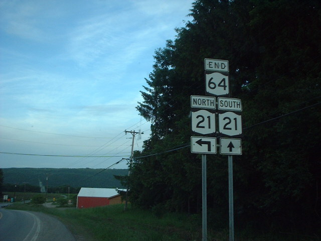
 Southern terminus of NY 64 at NY 21 in South Bristol
NY 64 begins at an intersection with NY 21 on a ridge overlooking Canandaigua Lake in Bristol Springs, a hamlet of South Bristol. The route heads to the northwest as a two-lane highway, running in the base of the Bristol Valley, a lowland created by a pair of imposing mountain ranges to the east and west that is home to the Bristol Mountain Ski Resort. At the hamlet of Bristol Center (in the town of Bristol), roughly 7.5 miles (12.1 km) from Bristol Springs, the western mountains give way to flat farmland while the eastern range continues on, although to a lesser extent and a lower elevation than before. The elevation of NY 64 remains virtually unchanged, however, as it progresses northward. 1.5 miles (2.4 km) from Bristol Center, the route meets US 20A.[3]
US 20A joins NY 64 here, following the latter for about 4 miles (6 km), allowing US 20A to terminate at its parent, US 20, here concurrent with NY 5, at an intersection in East Bloomfield. At this point, NY 64 turns west onto Routes 5 and 20. The three routes head westward across mostly open fields, meeting the southern terminus of NY 444 south of the former village of Holcomb. Past the junction,[3] which once served as the eastern terminus of NY 20C,[4] Routes 5, 20, and 64 continue into the village of Bloomfield before NY 64 breaks from NY 5 and US 20 and turns northward toward Rochester once again.[3]
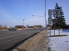 US 20 and NY 5 eastbound and NY 64 southbound at NY 444 near Bloomfield
A mere 50 yards (46 m) north of NY 5 and US 20, NY 64 meets the west end of Bloomfield's West Main Street at a rural intersection that was the western terminus of NY 20C.[3][4] North of West Main Street, the highway curves to the northwest as it exits East Bloomfield and enters the adjacent town of West Bloomfield. In the northeast corner of the town, NY 64 passes through the hamlet of Ionia. Northwest of the community, the route breaks to the north, taking a due north alignment as it passes into Monroe County and becomes Mendon–Ionia Road. The road stays on a relatively straight path northward as it heads through the rural southern portion of the town of Mendon to the hamlet of Mendon, where NY 64 meets NY 251 in the center of the community.[3]
On the opposite side of NY 251, NY 64 becomes Pittsford–Mendon Road. Outside of the hamlet, the highway maintains a consistent northerly alignment as it runs through slightly more populated areas of the town of Mendon and passes over the New York State Thruway (Interstate 90 or I-90). The route enters the town of Pittsford a short distance north of the Thruway, at which time NY 64 becomes Mendon Road. Within Pittsford, NY 64 passes through increasingly more populated areas as it approaches the village of Pittsford. Directly south of the village, the highway enters an intersection with South Main Street, Stone Road and Mendon Center Road at a sharp angle.[3] NY 253 once entered this junction on Mendon Center Road and followed NY 64 into Pittsford;[5] however, today, NY 64 continues alone onto South Main Street. The route ends just under 1 mile (1.6 km) later at the junction of South Main Street and Jefferson Road, where it meets NY 96 and NY 252.[3]
History
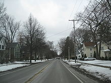 Approaching the northern terminus of NY 64 on NY 64 northbound in Pittsford
In 1908, the New York State Legislature created Route 14, an unsigned legislative route that extended from Corning to Rochester via South Bristol and Pittsford. The majority of Route 14 south of Pittsford was routed on what is now NY 64; however, in the vicinity of Bloomfield, Route 14 broke from modern NY 64 and used what later became NY 20C to access Holcomb. At the same time, the portion of current NY 64 that overlaps with US 20 and NY 5 was included in Route 6, a cross-state highway connecting Albany to Buffalo.[6][7] On March 1, 1921, Route 14 was altered to bypass Holcomb to the south on what is now NY 64.[8]
When the first set of posted routes in New York were assigned in 1924, the portion of legislative Route 14 between Mendon and Pittsford became part of NY 15, a route that mostly followed the current alignment of NY 96 from Owego to Rochester. Between Victor and Pittsford, however, NY 15 strayed from the modern routing of NY 96 and followed what is now NY 251 to Mendon. At the same time, the segment of legislative Route 6 in East Bloomfield became part of both NY 5 and NY 5A. The NY 5A designation was replaced along this stretch with NY 7 by 1926,[9][10] which in turn was replaced by US 20 in 1927.[11] In the 1930 renumbering of state highways in New York, NY 15 was realigned to bypass Mendon to the northeast by way of the current alignment of NY 96 between Victor and Pittsford. The former alignment of NY 15 from Pittsford to Mendon became part of NY 64,[1] a new route that extended south to South Bristol over the post-1921 routing of legislative Route 14.[12] Ca. 1939, the portion of NY 64 between Vincent and South Bloomfield became part of US 20A, which overlapped NY 64 for just under 4 miles (6 km) in order to connect to US 20.[13][14]
NY 64 briefly extended north of the village of Pittsford during the 1950s and 1960s. In the mid-1950s, NY 96 was realigned onto the new Eastern Expressway from Bushnell's Basin to NY 31F near East Rochester. From there, NY 96 followed modern NY 31F west to East Avenue, where it rejoined its original alignment. The portion of NY 96's original surface routing between the village of Pittsford and what is now NY 31F became part of an extended NY 64.[15][16] A northwest extension of the freeway to what is now the Can of Worms was completed ca. 1957 as a realignment of NY 96, resulting in another extension of NY 64 along East Avenue to the eastern edge of Rochester.[16][17] NY 64 and NY 96 were restored to their pre-1950s alignments ca. 1961 when the Eastern Expressway was designated as I-490.[18][19]
Major intersections
County Location Mile[2] Destinations Notes Ontario South Bristol 0.00 NY 21Hamlet of Bristol Springs Bristol 9.60  US 20A west
Southern terminus of US 20A / NY 64 overlap; hamlet of Vincent East Bloomfield 13.36 US 20 east / NY 5 east / US 20AEastern terminus of US 20 / NY 5 / NY 64 overlap; northern terminus of US 20A / NY 64 overlap; eastern terminus of US 20A 14.62  NY 444
Southern terminus of NY 444; former eastern terminus of NY 20C 16.43 US 20 west / NY 5 westWestern terminus of US 20 / NY 5 / NY 64 overlap West Main Street Former western terminus of NY 20C Monroe Mendon 24.70  NY 251
Village of Pittsford 31.06 NY 96 / NY 252Eastern terminus of NY 252 1.000 mi = 1.609 km; 1.000 km = 0.621 mi References
- ^ a b Dickinson, Leon A. (January 12, 1930). "New Signs for State Highways". The New York Times: p. 136.
- ^ a b "2008 Traffic Volume Report for New York State" (PDF). New York State Department of Transportation. June 16, 2009. p. 125. https://www.nysdot.gov/divisions/engineering/technical-services/hds-respository/NYSDOT%20TVR%202008%20by%20Route.pdf. Retrieved January 31, 2010.
- ^ a b c d e f g Yahoo! Inc. Yahoo! Maps – overview map of NY 64 (Map). Cartography by NAVTEQ. http://maps.yahoo.com/#mvt=h&lat=42.896115&lon=-77.449365&zoom=11&q1=42.705782%2C-77.376428&q2=42.975592%2C-77.502707&q3=43.08649%2C-77.518167. Retrieved April 12, 2010.
- ^ a b Map Works (1998). Canandaigua/Geneva/Farmington/Victor – Ontario County, New York (Map). ISBN 1-882488-45-8.
- ^ Mobil (1985). Mobil Travel Map – Buffalo, Niagara Falls, Rochester (Map). Cartography by Rand McNally and Company.
- ^ State of New York Department of Highways (1909). The Highway Law. Albany, New York: J. B. Lyon Company. pp. 57, 59. http://books.google.com/books?id=jZ0AAAAAMAAJ&pg=PA57. Retrieved April 12, 2010.
- ^ New York State Department of Highways (1920). Report of the State Commissioner of Highways. Albany, New York: J. B. Lyon Company. pp. 511, 522. http://books.google.com/books?id=Sj4CAAAAYAAJ&pg=PA511. Retrieved April 12, 2010.
- ^ New York State Legislature (1921). "Tables of Laws and Codes Amended or Repealed". Laws of the State of New York passed at the One Hundred and Forty-Fourth Session of the Legislature. Albany, New York: J. B. Lyon Company. pp. 42, 55–56. http://books.google.com/books?id=6pE4AAAAIAAJ&pg=PA42. Retrieved April 12, 2010.
- ^ "New York's Main Highways Designated by Numbers". The New York Times: p. XX9. December 21, 1924.
- ^ State of New York Department of Public Works (1926). Official Map Showing State Highways and other important roads (Map). Cartography by Rand McNally and Company.
- ^ Automobile Blue Book. 1 (1927 ed.). Chicago: Automobile Blue Book, Inc. 1927. This edition shows U.S. Routes as they were first officially signed in 1927.
- ^ Standard Oil Company of New York (1930). Road Map of New York (Map). Cartography by General Drafting.
- ^ Esso (1938). New York Road Map for 1938 (Map). Cartography by General Drafting.
- ^ Standard Oil Company (1939). New York (Map). Cartography by General Drafting.
- ^ Esso (1954). New York with Special Maps of Putnam–Rockland–Westchester Counties and Finger Lakes Region (Map). Cartography by General Drafting (1955–56 ed.).
- ^ a b Esso (1956). New York with Special Maps of Putnam–Rockland–Westchester Counties and Finger Lakes Region (Map). Cartography by General Drafting (1957 ed.).
- ^ Sunoco (1957). New York Including Long Island (Map). Cartography by H.M. Gousha Company.
- ^ Gulf Oil Company (1960). New York and New Jersey Tourgide Map (Map). Cartography by Rand McNally and Company.
- ^ Sunoco (1961). New York and Metropolitan New York (Map). Cartography by H.M. Gousha Company (1961–62 ed.).
External links
Categories:- State highways in New York
- Transportation in Monroe County, New York
- Transportation in Ontario County, New York


Wikimedia Foundation. 2010.