- Illogan
-
Coordinates: 50°15′01″N 5°16′04″W / 50.2503°N 5.2677°W
Illogan Cornish: Egloshal 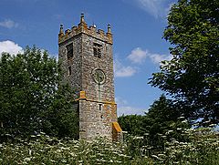
St Illogan Church Bell Tower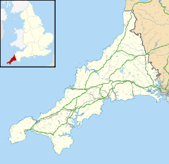
 Illogan
Illogan shown within CornwallPopulation 5,585 (Civil Parish, 2001) OS grid reference SW673439 Unitary authority Cornwall Ceremonial county Cornwall Region South West Country England Sovereign state United Kingdom Post town Redruth Postcode district TR16 Dialling code 01209 Police Devon and Cornwall Fire Cornwall Ambulance South Western EU Parliament South West England UK Parliament Camborne and Redruth List of places: UK • England • Cornwall Illogan (pronounced i'lluggan, Cornish: Egloshal) is a village and civil parish in Cornwall, United Kingdom. It is situated two miles (3 km) northwest of Redruth.[1]
Originally a rural area supporting itself by farming and agriculture, Illogan shared in the general leap into prosperity brought about by the mining boom, which was experienced by the whole Camborne-Redruth area.[2]
St Illogan Church Parish was the birthplace of engineer and inventor Richard Trevithick.[3]
Contents
Geography
There are two Illogan Parishes:
- St Illogan Church Parish stretching from Piece and Carnkie, to Portreath on the North Coast; Brea and Tuckingmill along the River Connor to the West; and Porthtowan, Sparnon Gate and Redruth Coombe to the East. The population is approximately 14,000; making it more populous than Redruth. It was the third largest in Cornwall. Before 1935, the Church and Civil Parish boundaries were the same. In 1935, Illogan Civil Parish was accidentally abolished in the Local Government Act 1933 which created Camborne-Redruth Urban District.[4]
- Illogan Civil Parish stretching from Bridge and Harris Mill in the East; Tolvaddon and Bell Lake in the West; and from the A30 to Reskajeage on the North Cliffs. In 1985, Civil Parish status was given back to Illogan, but as the population was too large, Illogan was divided into the Civil Parishes of Carn Brea, Illogan and Portreath.[4]
Church and school
The church is dedicated to Saint Illogan, of whom little is known.[5] The tower is all that remains of the medieval church: the new church was separate from it and was built to the designs of J. P. St Aubyn in 1846. Notable features are some fine monuments of the Bassets and others and the granite font.[6] The church contains a brass to James Basset, 1604[7]
The parish has a primary school with about 220 pupils.[8]
Magor Farm
Magor Farm is the site of the only Roman villa southwest of Exeter. In 1931 the ruins were found at Magor Farm, Illogan, and excavated under the guidance of the Royal Institution of Cornwall.[9] The villa was probably the residence of a wealthy Dumnonian who had adopted the Roman lifestyle.[10]
References
- ^ Ordnance Survey: Landranger map sheet 203 Land's End ISBN 978-0-319-23148-7
- ^ Thomas, J. (1990) Illogan: More than a Village, p.vii. Redruth: Dyllansow Truran. ISBN 1-85022-051-4
- ^ Payton, P.(2004) Cornwall: a History, p. 187. Fowey: Cornwall Editions
- ^ a b Holmes, P. (2010) 'Is Illogan a Village?' Illogan Parish Review, p.5. http://www.illoganparishcouncil.gov.uk/Core/IlloganPC/UserFiles/Files/Illoganreviewspring2010.pdf; retrieved 6 Feb 2011
- ^ "Parish Church website". http://www.saint-illogan.org.uk/.
- ^ Pevsner, N. (1970) Cornwall, 2nd ed. Penguin Books; pp. 82-83
- ^ Dunkin, E. (1882) Monumental Brasses. London: Spottiswoode
- ^ "Illogan Primary School website". http://www.illoganschool.ik.org/.
- ^ O'Neil, B. H. St. J. "Roman villa in Cornwall", Antiquity 5 (1931), pp. 494-5, with photographs
- ^ "Romano-British Villa Magor Farm, Illogan, Redruth, Cornwall". Roman-Britain.org. http://www.roman-britain.org/places/illogan.htm. Retrieved 2008-05-29.
External links
 Media related to Illogan at Wikimedia Commons
Geography of Cornwall Unitary authorities Major settlements Bodmin • Bude • Callington • Camborne • Camelford • Falmouth • Fowey • Hayle • Helston • Launceston • Liskeard • Looe • Lostwithiel • Marazion • Newlyn • Newquay • Padstow • Par • Penryn • Penzance • Porthleven • Redruth • Saltash • St Austell • St Blazey • St Columb Major • St Ives • St Just-in-Penwith • St Mawes • Stratton • Torpoint • Truro • Wadebridge
See also: Civil parishes in CornwallRivers Topics History • Status debate • Flag • Culture • Places • People • The Duchy • Diocese • Politics • Hundreds/shires • Places of interest • full list...Civil parishes of Camborne and Redruth constituency  Categories:
- Villages in Cornwall
- Civil parishes in Cornwall


Wikimedia Foundation. 2010.