- Midden-Delfland
-
Midden-Delfland — Municipality — 
Flag
Coat of armsCoordinates: 51°58′N 4°19′E / 51.967°N 4.317°ECoordinates: 51°58′N 4°19′E / 51.967°N 4.317°E Country Netherlands Province South Holland Area(2006) - Total 49.38 km2 (19.1 sq mi) - Land 47.45 km2 (18.3 sq mi) - Water 1.92 km2 (0.7 sq mi) Population (1 January, 2007) - Total 17,548 - Density 370/km2 (958.3/sq mi) Source: CBS, Statline. Time zone CET (UTC+1) - Summer (DST) CEST (UTC+2) Website www.middendelfland.nl Midden-Delfland (
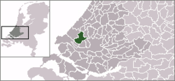
 pronunciation (help·info)) is a municipality in the Westland region in the province of South Holland in the Netherlands. It had a population of 17,072 in 2004, and covers an area of 49.38 km² of which 1.93 km² is water. Midden-Delfland is considered to be the main Cittaslow of The Netherlands.
It was formed on January 1, 2004, through the merger of the former municipalities:
- Maasland (population: 6,844), covered an area of 24.42 km² (of which 0.64 km² water).
- Schipluiden (population: 11,173), covered an area of 30.00 km² (of which 0.39 km² water).
The municipality comprises the population centres Hodenpijl, Den Hoorn, Gaag, Maasland, Negenhuizen, Schipluiden, 't Woudt, Zouteveen, and De Zweth.
The green area that comprises the municipality of Midden-Delfland was named Midden-Delfland before 2004, and it referred to the green area surrounded by cities (such as The Hague and Rotterdam) and the horticulture area of Westland. The supporters of a continuous green area were lucky that the municipality of Midden-Delfland became a reality: the cities of Delft, Vlaardingen and Schiedam wanted to build new houses here, and the Westland gardeners also wanted to expand. Now, Midden-Delfland is designated as a recreation area for people from the surrounding cities.
External links
- Official website
- Plan of Midden-Delfland
- Midden-Delfland Mooi Dichtbij Portal and click the British flag for English translation)
Categories:- Municipalities of South Holland
Wikimedia Foundation. 2010.


