- Rijnwoude
Infobox Settlement
official_name = Rijnwoude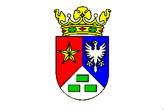
flag_size = 120x100px
image_shield = Rijnwoude coa.gif
shield_size = 120x100px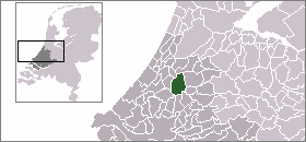
mapsize = 280px
subdivision_type = Country
subdivision_name =Netherlands
subdivision_type1 = Province
subdivision_name1 =South Holland
area_footnotes = (2006)
area_total_km2 = 57.85
area_land_km2 = 56.68
area_water_km2 = 1.17
population_as_of =1 January ,2007
population_note = Source: CBS, [http://statline.cbs.nl/ Statline] .
settlement_type = Municipality
population_total = 18772
population_density_km2 = 331
timezone = CET
utc_offset = +1
timezone_DST = CEST
utc_offset_DST = +2
latd = 52.10
latNS = N
longd = 4.58
longEW = E
website = [http://www.rijnwoude.nl www.rijnwoude.nl]. The municipality covers an area of 57.85 km² (22.34 mile²) of which 1.17 km² (0.45 mile²) is water.
Rijnwoude was formed in 1991 as Rijneveld through the merger of the former municipalities of Benthuizen,
Hazerswoude , and Koudekerk aan den Rijn. In 1993 the municipality was renamed to its current name Rijnwoude.The municipality of Rijnwoude consists of the communities
Benthorn ,Benthuizen ,Hazerswoude-Dorp ,Groenendijk ,Hazerswoude-Rijndijk (location of town hall),Hogeveen , andKoudekerk aan den Rijn .External links
*http://www.plattegronden.nl/rijnwoude/
Wikimedia Foundation. 2010.