- Giessenlanden
Infobox Settlement
official_name = Giessenlanden
flag_size = 120x100px
image_shield = Giessenlanden wapen.png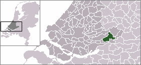
mapsize = 280px
subdivision_type = Country
subdivision_name =Netherlands
subdivision_type1 = Province
subdivision_name1 =South Holland
area_footnotes = (2006)
area_total_km2 = 65.12
area_land_km2 = 63.57
area_water_km2 = 1.55
population_as_of =1 January ,2007
population_note = Source: CBS, [http://statline.cbs.nl/ Statline] .
settlement_type = Municipality
population_total = 14452
population_density_km2 = 227
timezone = CET
utc_offset = +1
timezone_DST = CEST
utc_offset_DST = +2
latd = 51.86
latNS = N
longd = 4.92
longEW = E
website = [http://www.giessenlanden.nl www.giessenlanden.nl]. The municipality covers an area of 65.12 km² (25.14 mile²) of which 1.55 km² (0.60 mile²) is water.
The municipality of Giessenlanden consists the communities
Arkel ,Giessen-Oudekerk ,Giessenburg ,Hoogblokland ,Hoornaar ,Noordeloos , andSchelluinen .Public transportation
External links
* [http://www.giessenlanden.nl Official Website]
*http://www.plattegronden.nl/giessenlanden/
Wikimedia Foundation. 2010.