- Hardinxveld-Giessendam
Infobox Settlement
official_name = Hardinxveld-Giessendam
flag_size = 120x100px
image_shield = Coat of arms of Hardinxveld-Giessendam.gif
shield_size = 120x100px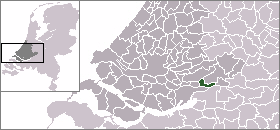
mapsize = 280px
subdivision_type = Country
subdivision_name =Netherlands
subdivision_type1 = Province
subdivision_name1 =South Holland
area_footnotes = (2006)
area_total_km2 = 19.35
area_land_km2 = 16.91
area_water_km2 = 2.45
population_as_of =1 January ,2007
population_note = Source: CBS, [http://statline.cbs.nl/ Statline] .
settlement_type = Municipality
population_total = 17681
population_density_km2 = 1046
timezone = CET
utc_offset = +1
timezone_DST = CEST
utc_offset_DST = +2
latd = 51.83
latNS = N
longd = 4.87
longEW = E
website = [http://www.hardinxveld-giessendam.nl www.hardinxveld-giessendam.nl]. The municipality covers an area of 19.35 km² (7.47 mile²) of which 2.44 km² (0.94 mile²) is water.
The municipality of Hardinxveld-Giessendam consists of the two population centres
Giessendam /Neder-Hardinxveld andBoven-Hardinxveld . Until they were merged together in 1957, Giessendam andHardinxveld were two municipalities, consisting of only a few streets and dykes and only a few thousand inhabitants.The town's ecomony is for a large part dependent on ship building (e.g.
Damen Shipyards Group ) and general contracting. Several industry parks are present.History
The village Hardinxveld is one of the oldest settlements of the
Alblasserwaard . It is known that in 1105 a priest was present here, and therefore a church as well. Since 1282, Hardinxveld became a grandfiefdom . Through the centuries it suffered from warfare such as the Gelder Wars and theEighty Years' War The name Giessendam first appeared in 1231 and is most likely derived from the dam on the little peat river Giessen. This dam was the boundary between Hardinxveld and Giessendam for a long time.
The municipality was formed in 1957 by the merger of the former municipalities Hardinxveld and half of Giessendam. The rest of Giessendam's territory went to the new municipality of Giessenburg which in turn was merged with
Giessenlanden in 1986.Since the 1960s, the municipality has grown significantly through the development of new neighbourhoods such as De Peulen, de Wielwijk, de Westwijk, and Tienmorgen. In recent years, the municipality had serious fiscal problems, resulting in direct oversight by the Province for a period of time. Considerable savings had to be made, necessitating significant increases to the relative low taxation in the town.
Archeology
Before the construction of the
Betuweroute Highspeed Railway, thorough soil research was performed in 1997. During that research in Hardinxveld-Giessendam, some archeological items were found, including a 7500-year old skeleton of a woman, now named "Trijntje". It is the oldest skeleton found in the Netherlands up to this time. Since December 2003, the reconstructed corpse has been added to the collection of theRijksmuseum van Oudheden (National Museum of Antiquities) inLeiden . In April 1998, a dugout canoe was found.Public transportation
External links
* [http://www.hardinxveld-giessendam.nl Official Website]
* [http://www.hardnixveld.nl Protest page of some citizens]
*http://www.plattegronden.nl/gemeentehardinxveld-giessendam/
Wikimedia Foundation. 2010.