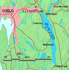
- Øyeren
-
Øyeren 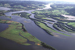

Map of Øyeren and surrounds Location Akershus and Østfold counties, Norway Coordinates 59°51′26″N 11°09′48″E / 59.85722°N 11.16333°ECoordinates: 59°51′26″N 11°09′48″E / 59.85722°N 11.16333°E Lake type Natural lake Basin countries Norway Surface area 84.74 km² Max. depth 71 m Shore length1 165.47 km Surface elevation 101 m References NVE 1 Shore length is not a well-defined measure. Øyeren is a lake in the Glomma river watershed, southeast of Lillestrøm. It is located within the municipalities of Enebakk, Skedsmo, Fet and Rælingen in Akershus county and Spydeberg and Trøgstad municipalities in Østfold county.
Øyeren lake is the ninth largest lake by area in Norway with a surface area of 84.7 km². It is 101 meters above sea level and 71 meters deep.
The name
The name of the lake (Norse Øyir) is derived from øy f 'island; flat and fertil land along a waterside'.
Nordre Øyeren nature preserve
An area which includes parts of the northern ("nordre") end of the lake is an established nature preserve, listed as a Ramsar site.
External links
- Øyeren information center (Norwegian )
- Nordre Øyeren natur preserve (Norwegian )
Lakes in Aust-Agder Åraksfjorden · Blåsjø · Botnsvatnet · Botsvatn · Breidvatn · Byglandsfjorden · Fisstøylvatnet · Grøssæ · Gyvatn · Hartevatnet · Herefossfjorden · Holmavatnet · Holmevatnet · Homstølvatnet · Hovatn · Høvringsvatnet · Kilefjorden · Kolsvatnet · Kvifjorden · Longerakvatnet · Måvatn · Myklevatnet · Nasvatn · Nelaug · Nesvatn · Nystølfjorden · Ogge · Ormsavatnet · Østre Grimevann · Øyarvatnet · Ramvatn · Reinevatn · Rore · Rosskreppfjorden · Sæsvatn · Skyvatn · Store Bjørnevatn · Store Urevatn · Storvatnet (Bykle) · Straumsfjorden · Syndle · Topsæ · Uldalsåna · Vatndalsvatnet · Vegår
Lakes in Buskerud Bjornesfjorden · Brommafjorden · Damtjern (Ringerike) · Djupsvatnet · Eikeren · Flakavatnet · Geitsjøen · Halnefjorden · Hettefjorden · Juklevatnet · Kravikfjorden · Krøderen · Langesjøen · Lauvnesvatnet · Mykle · Norefjorden · Nygardsvatnet · Nyhellervatnet · Øljusjøen · Ørteren · Øvre Hein · Øyangen (Ringerike) · Pålsbufjorden · Rødungen · Samsjøen (Ringerike) · Skaupsjøen · Sperillen · Strandavatnet · Tingvollfjorden (Buskerud) · Tinnhølen · Tisleifjorden · Tunhovdfjorden · Tyrifjorden · Ullerentjernet · Ustevatn · Vavatn · Vestre Bjonevatnet
Lakes in Finnmark Bajášjávri · Bajit Spielgajávri · Biggejávri · Bjørnstadvatnet · Čárajávri · Čorotjávri · Dátkojávri · Doggejávri · Gahččanjávri · Gákkajávri · Gardsjøen (Sør-Varanger) · Garsjøen · Gásadatjávri · Gavdnjajávri · Geađgejávri · Geašjávri · Geassájávri · Geatnjajávri · Guolehis Suolojávri · Hæmmujávri · Havvatnet · Idjajávri · Iešjávri · Juovvajávri · Kjæsvannet · Klistervatnet · Kovvatnet (Finnmark) · Láhpojávri · Latnetjávri · Nissojávri · Nuorbejávri · Rágesjávri · Sálganjávri · Soagŋojávri · Store Måsvann · Stuora Galbajávri · Stuorajávri (Alta) · Stuorajávri (Kautokeino) · Sundvatnet · Šuoikkatjávri · Suolojávri (Kautokeino) · Suolojávri (Lebesby) · Svanevatn · Virdnejávri · Vuolit Spielgajávri
Lakes in Hedmark Atnsjøen · Digeren · Engeren · Falningsjøen · Femund · Flensjøen · Fundin · Galtsjøen · Gardsjøen (Grue) · Gjesåssjøen · Gutulisjøen · Harrsjøen · Hukusjøen · Innerdalsvatnet · Isteren · Langsjøen · Lomnessjøen · Mangen · Marsjøen · Mjøsa · Møkeren · Nedre Roasten · Nugguren · Osensjø · Råsen · Rogen · Rokosjøen · Savalen · Siksjøen · Skasen · Skjervangen · Storsjø (Nord-Odal) · Storsjøen (Rendalen) · Vermunden · Vurrusjøen
Lakes in Hordaland Askevatnet · Askjelldalsvatnet · Bjølsegrøvvatnet · Blådalsvatnet · Eidfjordvatnet · Evangervatnet · Finsevatnet · Flakavatnet · Gjønavatnet · Granvinsvatnet · Halnefjorden · Hamlagrøvatnet · Henangervatnet · Holmavatnet (Hordaland) · Jordalsvatnet · Juklavatnet · Kalandsvatnet · Kvennsjøen · Langavatnet (Odda) · Lille Lungegårdsvannet · Løkjelsvatnet · Lønavatnet · Nordmannslågen · Onarheimsvatnet · Oppheimsvatnet · Ringedalsvatnet · Røldalsvatnet · Sandvinvatnet · Skaupsjøen · Skjerjavatnet · Skogseidvatnet · Stakkastadvatnet · Steinslandsvatnet · Storavatnet · Svartediket · Sysenvatnet · Tinnhølen · Torfinnsvatnet · Valldalsvatnet · Vangsvatnet · Veivatnet · Vigdarvatnet · Votna
Lakes in Møre og Romsdal Aursjøen · Brusdalsvatnet · Djupvatnet · Eikesdalsvatnet · Foldsjøen · Gråsjøen · Moldevatnet · Votna
Lakes in Nord-Trøndelag Almåsgrønningen · Andorsjøen · Bangsjøene · Byavatnet · Eidsvatnet · Feren · Finnvollvatnet · Fjergen · Fossemvatnet · Funnsjøen · Gilten · Grøningen · Grungstadvatnet · Gusvatnet · Hammervatnet · Havdalsvatnet · Hoklingen · Holden (Lierne) · Holden (Verran) · Holderen · Ingjelsvatnet · Innsvatnet · Jengelvatnet · Kalvvatnet · Kingen · Kvesjøen · Laksjøen · Leksdalsvatnet · Lenglingen · Limingen · Lysvatnet (Verran) · Mellingsvatnet · Meltingvatnet · Mjosundvatnet · Mokkavatnet · Movatnet · Murusjøen · Namsvatnet · Ormsetvatnet · Ovrejaevrie · Øyvatnet · Rengen · Saglivatnet · Salsvatn · Sandsjøen · Snåsavatnet · Sønningen · Store Øyingen · Storfrøyningen · Storgåsvatnet · Storgollomsvatnet · Storgrønningen · Stortissvatnet · Storvatnet (Leksvik) · Storvatnet (Nærøy) · Straumsetervatnet · Tunnsjøen · Tunnsjøflyan · Ulen · Veresvatnet
Lakes in Oppland Akksjøen · Atnsjøen · Aursjoen · Aursjøen · Avalsjøen · Bessvatnet · Breiddalsvatnet · Bukkehammartjørna · Bygdin · Dokkfløyvatn · Einavatnet · Feforvatnet · Flatningen · Fleinsendin · Gjende · Grønvatnet · Helin · Lalmsvatnet · Lemonsjøen · Lesjaskogsvatnet · Losna · Mjøsa · Nedre Heimdalsvatn · Olefjorden · Olstappen · Otrøvatnet · Øvre Sjodalsvatnet · Øyangen (Gran) · Øyangen (Nord-Fron) · Øyangen (Valdres) · Prestesteinsvatnet · Randsfjorden · Rauddalsvatn · Rondvatnet · Russvatnet · Samsjøen (Ringerike) · Sandvatnet/Kaldfjorden/Øyvatnet · Slettningen · Slidrefjord · Steinbusjøen · Strondafjorden · Tesse · Tisleifjorden · Tordsvatnet · Tyin · Vågåvatn · Vangsmjøse · Vestre Bjonevatnet · Vinstre
Lakes in Oslo Bogstadvannet · Lutvann · Nordre Puttjern · Østensjøvannet · Øvresetertjern · Sognsvann · Sværsvann · Tryvann
Lakes in Østfold Ara · Aspern · Femsjøen · Isesjøen · Lyseren · Mingevannet · Øgderen · Ørsjøen · Øyeren · Øymarksjøen · Rødenessjøen · Rømsjøen · Store Erte · Store Le · Vansjø · Vestvannet · Visterflo
Lakes in Rogaland Aksdalsvatnet · Austrumdalsvatnet · Blåsjø · Byrkjelandsvatnet · Edlandsvatnet · Eiavatnet · Flassavatnet · Frøylandsvatnet · Frøylandsvatnet (Sandnes) · Grøsfjellvatnet · Hofreistæ · Holmavatnet · Holmevatnet · Hovsvatnet · Limavatnet · Lundevatn · Nilsebuvatnet · Nodlandsvatnet · Oltedalsvatnet · Orrevatnet · Ørsdalsvatnet · Øvre Tysdalsvatnet · Stakkastadvatnet · Stokkavatnet (Forus) · Storvatnet (Bykle) · Suldalsvatnet · Teksevatnet · Tysdalsvatnet · Vatsvatnet · Vigdarvatnet · Vostervatnet ·
Lakes in Sogn og Fjordane Austdalsvatnet · Breimsvatn · Degnepollvatnet · Dingevatn · Eldrevatnet · Emhjellevatnet · Endestadvatnet · Fretheimsdalsvatnet · Holsavatnet · Holskardvatnet · Hornindalsvatnet · Jølstravatn · Juklevatnet · Lovatnet · Nyhellervatnet · Øljusjøen · Oppstrynsvatn · Prestesteinsvatnet · Styggevatnet · Tyin
Lakes in Sør-Trøndelag Ångardsvatnet · Aursund · Benna · Bolagen · Botn (Sør-Trøndelag) · Esandsjø · Femund · Feragen · Flensjøen · Fundin · Gagnåsvatnet · Gjevilvatnet · Håsjøen · Hostovatnet · Jonsvatnet · Korssjøen · Malmsjøen · Nedre Roasten · Nesjø · Øyangsvatnet · Øyungen · Rambergsjøen · Riasten · Rien · Rogen · Samsjøen (Sør-Trøndelag) · Selbusjø · Sørungen · Stordalsvatnet · Storvatnet (Leksvik) · Straumsetervatnet · Svorksjøen · Vasslivatnet · Våvatnet
Lakes in Telemark Bandak · Bolkesjø · Farris · Flåvatn · Fyresvatn · Holmavatnet · Kalhovdfjorden · Kviteseidvatn · Møsvatn · Nisser · Norsjø · Songevatnet · Tinnsjå · Toke · Totak
Lakes in Troms Altevatnet · Geavdnjajávri · Leinavatn · Lille Rostavatn · Lysvatnet (Lenvik) · Niingsvatnet · Prestvannet · Rihpojávri · Rostojávri · Šuoikkatjávri
Lakes in Vest-Agder Gjuvvatnet · Gravatnet · Gyvatn · Kilefjorden · Kulivatnet · Kumlevollvatnet · Kvifjorden · Lundevatn · Lygne · Nåvatnet · Øre · Øyarvatnet · Rosskreppfjorden · Selura · Sirdalsvatnet · Storvatnet (Bykle) · Valevatn · Ytre Øydnavatnet
Lakes in Vestfold Eikeren · Farris · Goksjø · Hallevatnet
Categories:- Lakes of Akershus
- Lakes of Østfold
- Ramsar sites in Norway
- Enebakk
- Akershus geography stubs
- Østfold geography stubs
- European protected area stubs

Wikimedia Foundation. 2010.