- Glomma
Geobox|River
name = Glomma
native_name =
other_name = Glåma
category =
etymology =Old Norse , "Glaumr", from "raumr": "noise," "racket"
nickname =

image_caption = Glomma at Solbergfoss power plant,Østfold
country =Norway
state =
region =
district =
municipality =
parent =
tributary_left =Vorma
tributary_right = Rena
city =
landmark =
source =Aursund
source_location =Røros | source_region =Sør-Trøndelag | source_country =Norway
source_elevation = 690
source_lat_d = 62 | source_lat_m = 37 | source_lat_s = 06 | source_lat_NS = N
source_long_d = 11 | source_long_m = 48 | source_long_s = 11 | source_long_EW = E
source1 =
source1_location = | source1_region = | source1_country =
source1_elevation =
source1_lat_d = | source1_lat_m = | source1_lat_s = | source1_lat_NS =
source1_long_d = | source1_long_m = | source1_long_s = | source1_long_EW =
source_confluence =
source_confluence_location = | source_confluence_region = | source_confluence_country =
source_confluence_elevation =
source_confluence_lat_d = | source_confluence_lat_m = | source_confluence_lat_s = | source_confluence_lat_NS =
source_confluence_long_d = | source_confluence_long_m = | source_confluence_long_s = | source_confluence_long_EW =
mouth = Fredrikstad
mouth_location =Fredrikstad | mouth_region =Østfold | mouth_country = Norway
mouth_elevation = 0
mouth_lat_d = 59 | mouth_lat_m = 13 | mouth_lat_s = 04 | mouth_lat_NS = N
mouth_long_d = 10 | mouth_long_m = 55 | mouth_long_s = 51 | mouth_long_EW = E
length = 604
width =
depth =
volume = 698
watershed = 42000
discharge =
discharge_max =
discharge_min =
free = | free_type =
map_caption = Glomma route
map_background =
map_locator =
map_locator_x =
map_locator_y =
website =
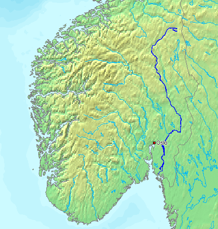
footnotes =Glomma, also known as Glåma is the longest and largest river in
Norway , 598 kilometers long. Its drainage basin covers fully 13% of Norway's area, all in the Southern part of Norway.At its fullest length, the river runs from lake
Aursund nearRøros inSør-Trøndelag and runs into theOslofjord atFredrikstad . Major tributaries include theVorma River, which drains Lake Mjøsa, joining the Glomma River at Nes. The Lågen drains into Lake Mjøsa, collecting drainage from the largeGudbrandsdal valley and significantly increasing the Glomma's flow.Because it flows through some of the richest forest districts, it has historically been Norway's leading log floating river. The combination of raw materials, water power, and easy transport has over the centuries encouraged industry along the Glomma. Some of the country's largest manufacturing and processing concerns are found around its mouth, where supplies of timber and hydro-power have been backed by excellent port facilities.
The upper limit of Glomma valley farms is variable, but typically runs about 500 meters (1650 feet) in the Østerdal, slightly lower than in the
Gudbrandsdal , which reflects the colder climate. The treeline, with a light birch forest, rises to about 900 meters (3000 feet) in the Østerdal. AboveRøros the forest is restricted to the valley floor.The upper river valleys of Norwegian rivers have distinctive names which are vestiges of earlier cultural distinctions such as building styles, traditional clothing or
bunad and domestic crafts. The upper valley of the Glomma is theØsterdal (or East Valley).Upon entering
Lake Øyeren atFetsund , the Glomma has formed Europe's largest inland delta which reaches the opposite side of the lake, across its short axis. Some of the vast amount of silt that the Glomma deposits in Lake Øyeren is extracted to manufactureLECA building blocks widely used for in the construction of foundations in Norway.The name
The form "Glomma" are used in the counties of
Østfold andAkershus . In the counties ofHedmark andSør-Trøndelag the river is called (and written) "Glåma". The name is very old, and the meaning is unknown.Several places are named after the river, for instance
Glåmdal andGlåmos .References
* "Scandinavia; An Introductory Geography", by Brian Fullerton & Alan Williams, Praeger Publishers, 1972.
Wikimedia Foundation. 2010.