- Enebakk
Infobox_Kommune
name=Enebakk
idnumber=0229
county=Akershus
landscape=Follo
capital=Kirkebygda
governor=Dag Bjerke (Frp)
governor_as_of=2008
arearank=312
area=233
arealand=195
areapercent=0.07
population_as_of=2004
populationrank=111
population=9,233
populationpercent=0.20
populationdensity=47
populationincrease=14.5
demonym=Enebakking
language=Bokmål
lat_deg=59| lat_min=46| lat_sec=27| lon_deg=11| lon_min=6| lon_sec=7
utm_zone=32V| utm_northing=6628159 |utm_easting=0618038| geo_cat=adm2nd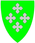
munwebpage=www.enebakk.kommune.no
Enebakk is a municipality in the county of
Akershus ,Norway .The parish of "Enebak" was established as a municipality January 1, 1838 (see
formannskapsdistrikt ).Geography
Enebakk is divided into four areas, named
Flateby ,Kirkebygda ,Dalefjerdingen andYtre Enebakk , being closest toOslo .The highest point in Enebakk is Vardåsen, situated between the lakes
Børtervann andØyeren , at 374 m above sea level.Enebakk is a mere 30 km from the city-limits of
Oslo , with easy bus-access to the country's capital. There are of 2004 no train-stations in the municipality.The name
The municipality (originally the parish) is named after the old farm Enebakk (Norse "Ignarbakki"), since the first church was built here. The first element is the genitive case of a rivername "Ign" (meaning unknown), the last element is "bakki" m 'riverbank'. In Norse times the parish was alternatively called "Ignardalr" 'the valley of (the river) Ign'.
Until 1921 the name was written "Enebak".
Coat-of-arms
The coat of arms is from modern times (1986) - but it is inspired by old mural paintings in the Enebakk church from the Middle Ages. It shows four fourblades. The number four shall remind of the four parts of the municipality (see above).
External links
* [http://www.enebakk.kommune.no Official site]
Wikimedia Foundation. 2010.