- Buskerud
Infobox Fylke
name = Buskerud
idnumber = 06
capital =Drammen
mayor = Roger Ryberg
mayor_date = 2007
mayor_party = Arbeiderpartiet
governor =Kirsti Kolle Grøndahl
governor_date = 1999
governor_party = Arbeiderpartiet
region = Østlandet
arearank = 12
area = 14910
arealand = 13797
areapercent = 4.53
population_as_of = 2008
populationrank = 8
population = 253,006
populationpercent = 5.29
populationdensity = 18
populationincrease = 6.7
gdp_as_of = 2001
gdprank = 7
gdp = 54,474
gdppercent = 3.57
gdpcapita = 227,626
incomecapita = 155,400
munwebpage = www.bfk.no
language = Neutral
demonym = BuskerudfolkAudio|Buskerud.ogg|Buskerud is a county in
Norway , borderingAkershus ,Oslo ,Oppland ,Sogn og Fjordane ,Hordaland ,Telemark , andVestfold . The county administration is located inDrammen .Geography
Buskerud extends from
Hurum at theOslofjord to the Halling mountains andHardanger . The county is conventionally divided into traditional districts. These areEiker , Ringerike,Numedal andHallingdal .Hønefoss is the district capital ofRingerike . Its western part is a mountainous plateau with forested valleys and high, grassy pastures; its eastern part contains a lowland basin with many lakes and streams.Tyrifjorden andKrøderen are the biggest lakes.Numedalslågen , the third longest river in Norway, starting inHordaland , runs through Buskerud unto Vestfold where it reaches the sea, while riverBegna sweeps into lakeSperillen .History
Buskerud was separated from
Akershus as anamt of its own in 1685, but the area of this one it was smaller than today. (It then consisted of the present municipalities ofFlå , Gol,Hemsedal ,Hol , Hole,Krødsherad ,Modum ,Nedre Eiker , Nes,Ringerike ,Sigdal ,Øvre Eiker andÅl .) The area of the present municipalities ofFlesberg ,Hurum ,Kongsberg , Lier,Nore og Uvdal ,Rollag andRøyken were transferred from Akershus amt to Buskerud amt in 1760. The name "Buskeruds amt" was changed to "Buskerud fylke" in 1919. The municipality ofSkoger was transferred fromVestfold to Buskerud in 1964.The area Ringerike may once have been a small kingdom. During the 10th century, Norway's kings Olav Trygvason and Olav Haraldsson grew up at Bønsnes in Ringerike. In the
Numedal valley,silver has been mined inKongsberg from the 17th century but was discontinued in 1957. Weapons industry had been developed in Kongsberg from 1814, and various high tech industry companies now represent the town's major employers. AtModum there once was aCobalt pigment production works ("Blaafarveværket", "The Blue-Color Works").Economy
Today, agriculture, lumbering, wood-pulp mills, and industry are the county's main economic activities; ample hydroelectric power is produced by Begna and Rands rivers.
The name
The county is named after the old farm Buskerud (Norse "Biskupsruð") in
Modum , since this was the seat of the bailiffs in old time (until 1668). The first element is the genitive case of "biskup" m 'bishop', the last element is "ruð" n 'clearing, farm'. (The farm originally belonged to the bishop of Oslo.)Coat of arms
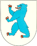
Buskerud's coat of arms (created in April, 1966) features a blue
bear whose coloring is symbolic of the Blue-Color Works. The silver background of Buskerud's coat of arms represents the silver industry in Kongsberg.Municipalities
Buskerud County has a total of 21 municipalities:
External links
* [http://www.buskerud-f.kommune.no/ Buskerud Fylkeskommune]
Wikimedia Foundation. 2010.