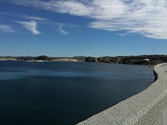
- Blåsjø
-
Blåsjø Location Bykle, Aust-Agder
Hjelmeland, Rogaland
Suldal, RogalandCoordinates 59°22′N 6°53′E / 59.367°N 6.883°ECoordinates: 59°22′N 6°53′E / 59.367°N 6.883°E Basin countries Norway Surface area 84.48 km2 (32.62 sq mi) Water volume 3.1 km3 (0.74 cu mi) Shore length1 200.41 km (124.53 mi) Surface elevation 1,055 m (3,461 ft) 1 Shore length is not a well-defined measure. Blåsjø is the tenth largest lake in Norway by area. It is located in the municipality of Bykle in Aust-Agder county and the municipalities of Hjelmeland and Suldal in Rogaland county. The lake is about 20 kilometres (12 mi) west of the village of Bykle. It has a surface area of 84.48 square kilometres (32.62 sq mi). It lies 1,055 metres (3,461 ft) above sea level and has a shoreline of about 200 kilometres (120 mi).
Blåsjø was formed by building a series of dams on several small lakes and it functions as a reservoir for the Ulla-Førre hydroelectric power station. The lake has an annual energy generation potential of about 7.8 terawatt-hours (28 PJ).[1]
References
- ^ "Blåsjø" (in Norwegian). Store norske leksikon. http://www.snl.no/Bl%C3%A5sj%C3%B8. Retrieved 2010-05-16.
Categories:- Lakes of Aust-Agder
- Lakes of Rogaland
- Bykle
- Hjelmeland
- Suldal
- Aust-Agder geography stubs
- Rogaland geography stubs
Wikimedia Foundation. 2010.

