- Jeju-do
-
Jeju
Special Self-Governing Province
제주특별자치도濟州特別自治道
Jeju Teukbyeoljachi-do
Emblem of Jeju
Map of South Korea with Jeju highlighted Government Special Self-Governing Province Capital Jeju City Governor Woo Keun-min Dialect Jeju Region Jeju Area 1,848 km²(9th) Population (2005) - Population 531,887 (9th) - Density 287 /km² Cities 2 Counties 0 Website jeju.go.kr (English) Metropolitan Symbols - Flower Chamkkot - Tree Cinnamomum camphora - Bird Woodpecker Jejudo Native name: 제주도/濟州島 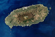
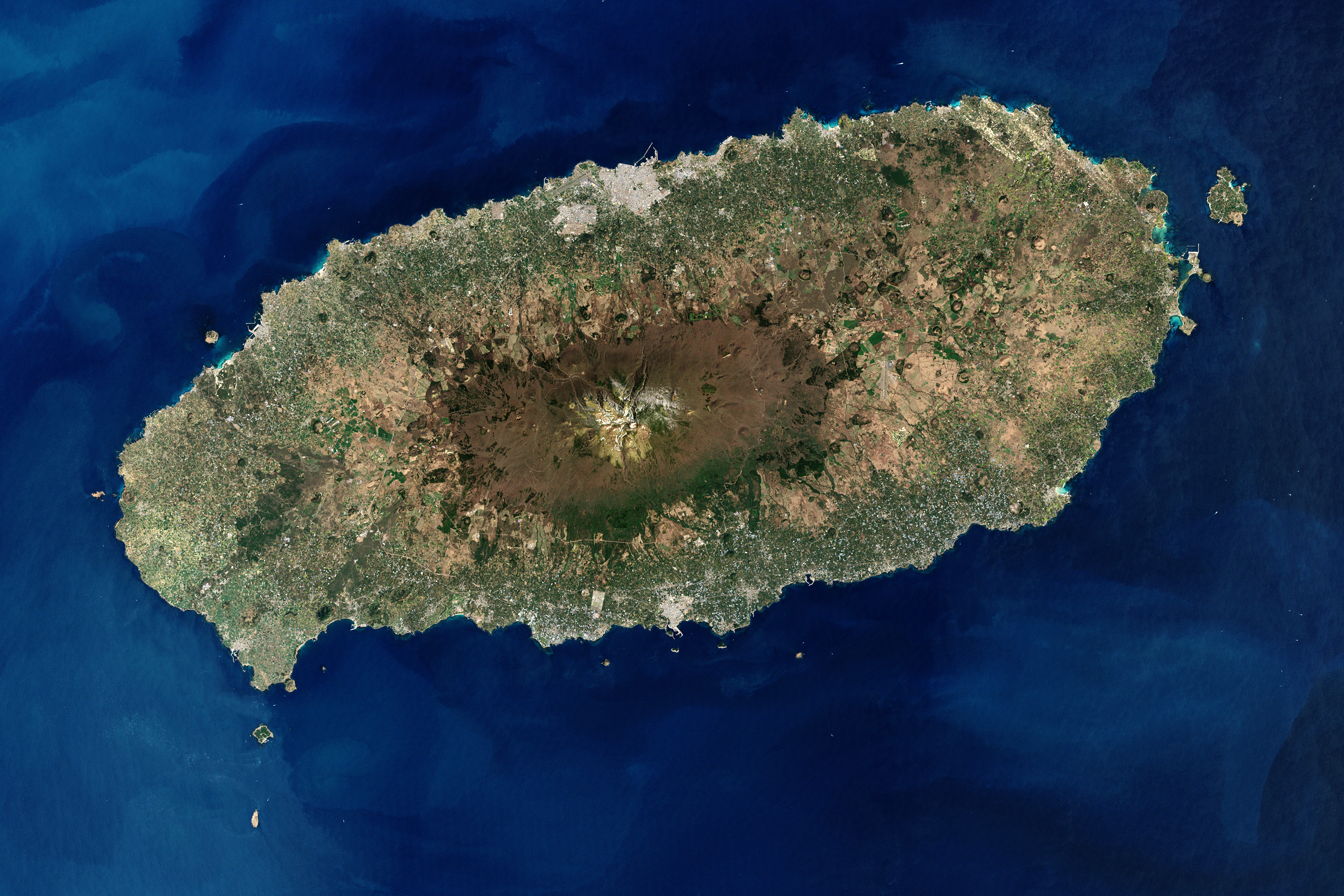
Jeju Island, South KoreaGeography Location East Asia Archipelago Jeju Area 1,848 km2 (713.5 sq mi) Highest elevation 1,950 m (6,400 ft) Highest point Hallasan Country South KoreaSpecial Self-Governing Province Jeju-do Largest city Jeju City (pop. 408,364) Demographics Population approx. 565,000 Ethnic groups Korean Jeju-do[1] (transliterated Korean for Jeju Province, short form of Jeju Special Self-Governing Province or Cheju Island) is the only special autonomous province of South Korea, situated on and coterminous with the country's largest island. Jeju-do lies in the Korea Strait, southwest of Jeollanam-do Province, of which it was a part before it became a separate province in 1946. Its capital is the city of Jeju.
The island contains the Natural World Heritage Site Jeju Volcanic Island and Lava Tubes.[2]
Contents
History
Early history
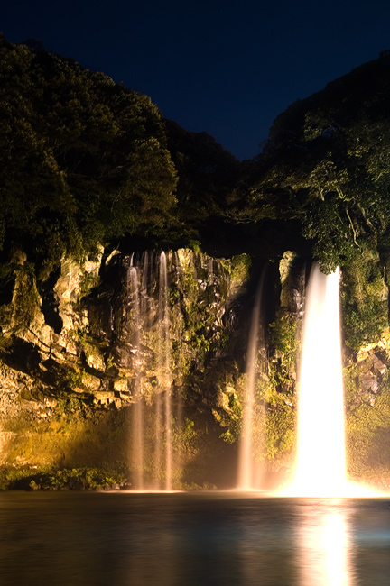
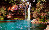 Cheonjiyeon Waterfall on Jeju Island.
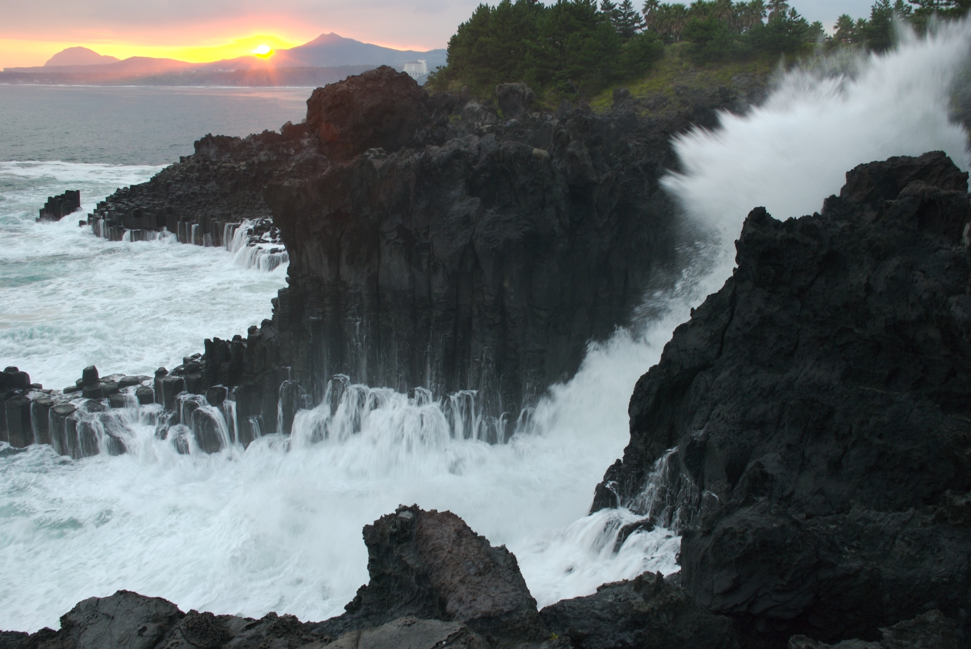
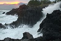 Waves crashing on Jeju seashore.
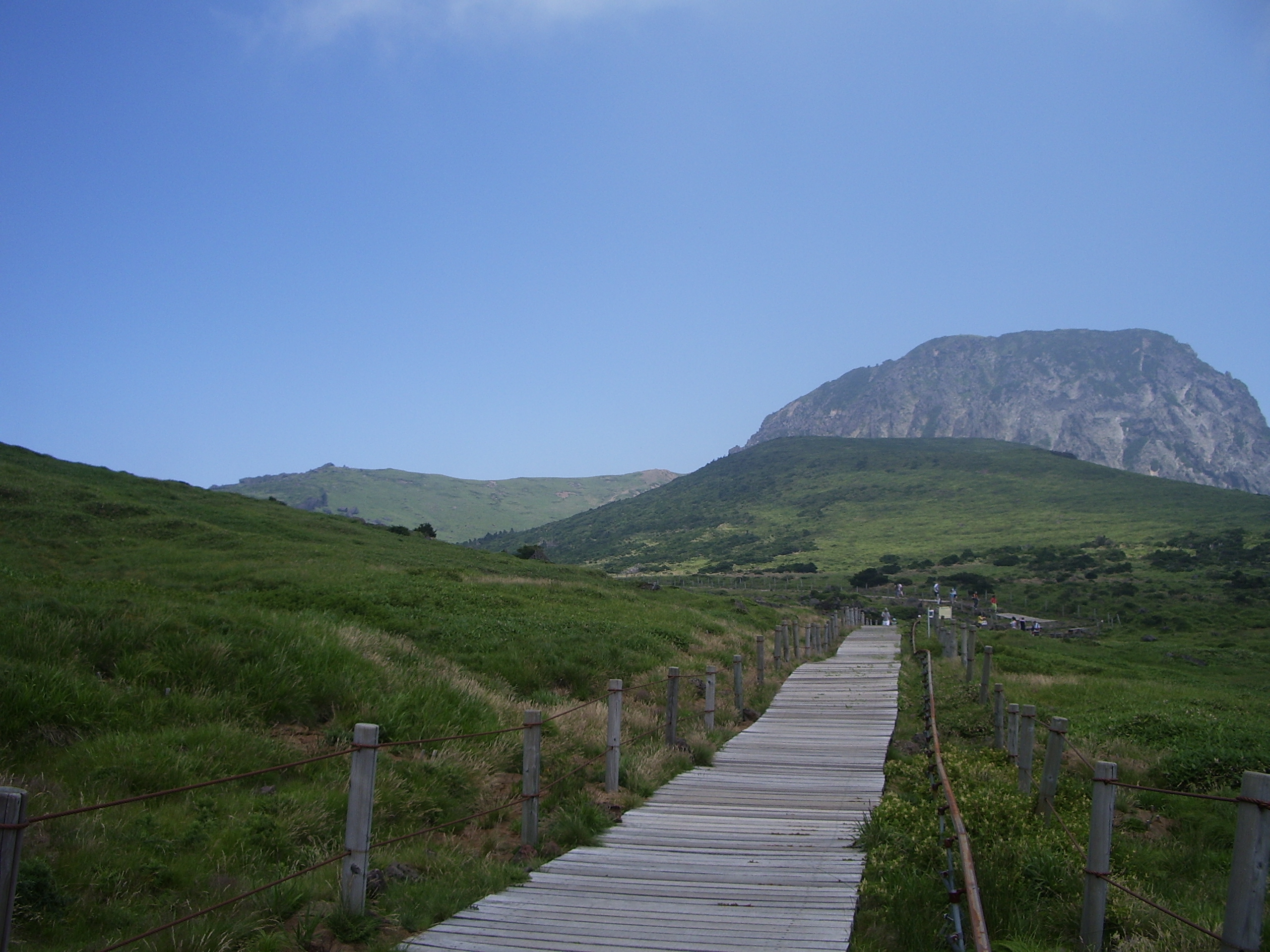
 Halla Mountain in Jeju.
 Cheonjiyeon Waterfall in Jeju.
According to legend, three demi-gods emerged from Samsung-hyeol which is said to have been on the northern slopes of Mt. Halla and became the progenitors of the Jeju people who founded the Kingdom of Tamna.
It has also been claimed that three brothers including Ko-hu who were the 15th descendants of Koulla, one of the Progenitors of the Jeju people, were received by the court of Silla at which time the name Tamna was officially recognized, while the official government posts of Commander, Prince and Governor were conferred by the court upon the three.
However, there is no concrete evidence of when the "Three Names" (Samseong-Ko, Yang and Pu) appeared nor for the exact date of when Ko-hu and his brothers were received by Silla. It may be supposed that the founding Period by the "Three Names" occurred during the Three Kingdoms (Goguryeo, Baekje and Silla) period on the mainland of Korea.
Taejo, founder of Goryeo, attempted to establish the same relationship between Goryeo and Tamna as Tamna had had with Silla. Tamna refused to accept this position and the Goryeo court dispatched troops to force Tamna to submit. Ko ja-gyeon, chief of Tamna, submitted to Goryeo in 938 and sent his son, Prince Mallo, to Goryeo's court as a de-facto hostage. In 1105 (King Sukjong's 10th year), the Goryeo court abolished the name Takna which had to this time been used and from that year on, the island was known as "Tamna-gun" (district) and Goryeo officials were sent to handle the affairs of the island.
Tamna-country was changed to Tamna-county in 1153 during the reign of King Uijong and Choi Cheok-kyeong was posted as Tamna-Myeong or Chief of Tamna. In 1121 during Huijong's reign, Tamna was renamed "Jeju" and the posts of Judiciary were established on the island.
In 1271, General Kim Tong-jeong escaped with what remained of his Sambyeolcho force from Jindo and built the Hangpadu Fortress at Kwiil-chon from where they continued their fight against the combined Korean government-Mongolian army but within 2 years, faced by an enemy army of over 10,000 troops, the Sambyeolcho was annihilated.
Modern history
Jeju Uprising, 1948
Main article: Jeju UprisingThe Jeju Uprising, which began on April 3, 1948, was part of a larger problem across Korea at this time. The rebellions on Jeju-do, which resulted in the deaths of hundreds of officials, armed organizations, and villagers alike culminated in widespread violence on the island and the center of the island (Halla Mountain) being listed as an "enemy zone" by the government of the Republic of Korea. Over 30,000 people were killed as some villagers and communist radicals alike were imprisoned in internment camps under the policies of mainland government.[3]
While claims have been made that the US government oversaw and supported "anti-communist" activities administratively if not openly in the field, validation remains to be made. It is a fact the US was heavily involved in counter insurgence operations across Korea at this time leading up to the Korean War and UN involvement. Similarly, the Northwest Youth League, a Korean government sponsored watch-dog group made up of refugees who had fled northern Korea, actively repressed any and all "communist sympathizers" with an ardent campaign of shooting anyone on sight entering or leaving the president's "enemy zone", raping/violation, torturing, and killing hundreds of islanders using open armed violence and what would be labeled today as terrorist activities. Intolerance by mainland Korean officials of islanders in general at the time, government and organization sponsored isolation of the island, and rumored cover up of evidence linking the rebellion's suppressors with foreign powers and people who have today gone un-prosecuted is believed to be the primary cause of public ignorance, hedging on denial, over the April 3, 1948 genocide on Cheju-do. A documentary by the BBC and PBS, Korea: The Unknown War and many activities and publications by organizations and persons from within Cheju-do and around the world continue to attempt shedding the light on this event.
The provincial administrative building was burned to the ground in September 1948 and a new building was completed in 1-do, 2-dong in December, 1952.
In June 2007, the Korean government selected Gangjeong, a village on the southern coast of the island, as the site of a $970 million naval base.[4] The base is to house twenty warships, including submarines.[5]
In January 2010, the South Korean Navy signed two contracts with two construction firms to build pier facilities.[4]; construction began in January 2011.[5] By August, about 14 percent of the contract had been spent on initial construction work, but significant progress had not been made due to local resistance to the base.[4]
Trying to prevent dredging and bulldozing, residents of Gangjeong have been living in tents in and near areas where construction is planned or ongoing. In addition to protests, the villagers have filed lawsuits to try to block construction, and have widely publicized their opposition.[6] The government has responded by stationing hundreds of police officers at the construction site, charging and fining protestors for obstruction, and jailing peace activist Choi Sung-hee [7] for three months.
The South Korean Navy has erected a billboard in the village displaying an artist’s conception of a state-of-the-art, "eco-friendly" port, covering about 125 acres and receiving luxury cruise ships as well as military vessels.[5] In August 2011, a spokesperson for the Korean Government said that the construction site was selected after accommodating opinions of local residents, that environmental assessments had shown the project would have no effect on the environment, and that measures were being taken to protect vulnerable species native to the island.[8]
Historical names
Historically, the island has been called by many different names including:
- Doi (도이, 島夷, literally "Island barbarian")
- Dongyeongju (동영주, 東瀛州)
- Juho (주호, 州胡)
- Tammora (탐모라, 耽牟羅)
- Seomna (섭라, 涉羅)
- Tangna (탁라, 乇羅)
- Tamna (탐라, 耽羅)
- Quelpart (q.v. gyulbat, 귤밭, 橘밭, literally "orange orchards")
Before the Japanese annexation in 1910, the island was usually known as Quelpart to Europeans. The name "Quelpart" apparently came from the first European ship to spot the island, the Dutch "Quelpaert", which sighted it after being blown off course on its way to the Dutch trading base in Nagasaki, Japan, from Taiwan (then the Dutch colony of Formosa).
When Korea was annexed by Japan in 1910, Jeju then became known as Saishū, which is the Japanese reading of the hanja for Jeju.
Before 2000, when the Seoul government changed the official Romanization of Hangul, Jeju-do was spelled Cheju-do. Almost all written references to the island before that use that spelling.
Geography
Jeju Island is a volcanic island, dominated by Halla-san (Halla Mountain): a volcano 1,950 metres (6,400 ft) high and the highest mountain in South Korea. The island measures approximately 175 kilometres (109 mi) across, end to end, at the widest points.
The island was created entirely from volcanic eruptions approximately 2 million years ago, during the time period from the Tertiary to the beginning of the Quaternary period, and consists chiefly of basalt and lava. The eruptions took place in the Cenozoic era. It has a humid subtropical climate, warmer than that of the rest of Korea, with four distinct seasons. Winters are cool and dry while summers are hot, humid, and sometimes rainy.
There is a crater lake which is the only crater lake in South Korea.[citation needed]
An area covering about 12% (224 square kilometres or 86 square miles) of Jeju is known as Gotjawal Forest.[9] This area had remained untouched until the 21st century, as its base of ʻAʻā lava made it difficult to develop for agriculture. Because this forest remained untouched for a long time, it has a unique ecology.[10] The forest is the main source of groundwater, the main water source for the half millon people of the island, because rainwater penetrates directly into the groundwater aquifer through the cracks of the ʻAʻā lava under the forest. Gotjawal forest is considered an internationally important wetland under the Ramsar Convention by some researchers[11] because it is the habitat of unique species of plants and is the main source of water for the residents, although to date it has not been declared a Ramsar site.[12]
Climate
Climate data for Jeju-si, Jeju-do (1981−2010) Month Jan Feb Mar Apr May Jun Jul Aug Sep Oct Nov Dec Year Average high °C (°F) 8.3
(46.9)9.4
(48.9)12.8
(55.0)17.5
(63.5)21.6
(70.9)24.8
(76.6)29.0
(84.2)29.8
(85.6)25.8
(78.4)21.3
(70.3)16.0
(60.8)11.0
(51.8)18.9 Average low °C (°F) 3.2
(37.8)3.6
(38.5)6.1
(43.0)10.2
(50.4)14.4
(57.9)18.7
(65.7)23.3
(73.9)24.3
(75.7)20.4
(68.7)15.1
(59.2)9.8
(49.6)5.3
(41.5)12.9 Precipitation mm (inches) 65.2
(2.567)62.6
(2.465)88.6
(3.488)89.6
(3.528)96.4
(3.795)181.4
(7.142)239.9
(9.445)262.5
(10.335)221.6
(8.724)80.3
(3.161)61.9
(2.437)47.7
(1.878)1,497.6
(58.961)% humidity 65.3 64.9 64.9 66.5 70.4 76.8 78.3 76.5 73.7 66.9 65.1 65.1 69.6 Avg. precipitation days (≥ 0.1 mm) 12.6 10.3 11.2 10.0 10.4 11.8 12.5 13.5 10.8 7.0 9.3 10.8 130.2 Sunshine hours 70.4 105.4 158.9 194.4 211.9 170.9 195.6 195.6 161.7 178.5 126.0 84.8 1,854.1 Source: Korea Meteorological Administration [13] Climate data for Seogwipo-si, Jeju-do (1981−2010) Month Jan Feb Mar Apr May Jun Jul Aug Sep Oct Nov Dec Year Average high °C (°F) 10.7
(51.3)11.6
(52.9)14.4
(57.9)18.5
(65.3)22.0
(71.6)24.6
(76.3)28.3
(82.9)30.1
(86.2)27.4
(81.3)23.4
(74.1)18.2
(64.8)13.2
(55.8)20.2 Average low °C (°F) 3.6
(38.5)4.4
(39.9)7.1
(44.8)11.3
(52.3)15.3
(59.5)19.2
(66.6)23.5
(74.3)24.6
(76.3)21.1
(70.0)15.9
(60.6)10.6
(51.1)5.9
(42.6)13.5 Precipitation mm (inches) 61.0
(2.402)77.1
(3.035)131.2
(5.165)174.9
(6.886)205.8
(8.102)276.9
(10.902)309.8
(12.197)291.6
(11.48)196.6
(7.74)81.6
(3.213)71.4
(2.811)45.1
(1.776)1,923.0
(75.709)% humidity 62.8 62.1 62.4 64.5 69.9 78.2 84.1 79.0 72.5 63.9 63.2 62.2 68.7 Avg. precipitation days (≥ 0.1 mm) 10.3 9.5 11.0 10.5 10.7 12.9 14.3 14.2 10.3 6.1 7.4 8.1 125.3 Sunshine hours 152.2 152.6 174.0 190.9 199.0 144.2 142.1 184.2 176.1 207.1 170.5 161.8 2,054.7 Source: Korea Meteorological Administration [14] Climate data for Seongsan-eup, Jeju-do (1981−2010) Month Jan Feb Mar Apr May Jun Jul Aug Sep Oct Nov Dec Year Average high °C (°F) 9.0
(48.2)10.2
(50.4)13.4
(56.1)17.8
(64.0)21.6
(70.9)24.2
(75.6)27.9
(82.2)29.5
(85.1)26.5
(79.7)22.0
(71.6)16.6
(61.9)11.4
(52.5)19.2 Average low °C (°F) 2.0
(35.6)2.4
(36.3)5.2
(41.4)9.2
(48.6)13.5
(56.3)17.6
(63.7)22.4
(72.3)23.6
(74.5)20.2
(68.4)14.2
(57.6)8.4
(47.1)3.9
(39.0)11.9 Precipitation mm (inches) 83.2
(3.276)69.7
(2.744)142.2
(5.598)150.1
(5.909)177.7
(6.996)223.7
(8.807)283.2
(11.15)360.6
(14.197)228.4
(8.992)90.8
(3.575)85.1
(3.35)72.0
(2.835)1,966.8
(77.433)% humidity 67.5 65.1 65.0 66.7 71.4 81.1 84.4 80.6 75.3 68.4 67.8 67.6 71.7 Avg. precipitation days (≥ 0.1 mm) 11.1 9.1 10.9 9.1 9.4 12.4 13.0 13.6 9.8 5.8 7.7 8.9 120.8 Sunshine hours 122.5 146.9 170.1 192.9 205.3 145.6 157.4 173.4 157.2 187.8 155.5 130.3 1,944.7 Source: Korea Meteorological Administration [15] Climate data for Gosan-ri, Jeju-do (1981−2010) Month Jan Feb Mar Apr May Jun Jul Aug Sep Oct Nov Dec Year Average high °C (°F) 8.6
(47.5)9.4
(48.9)12.3
(54.1)16.5
(61.7)20.0
(68.0)23.4
(74.1)27.3
(81.1)29.1
(84.4)26.0
(78.8)21.2
(70.2)16.2
(61.2)11.2
(52.2)18.4 Average low °C (°F) 3.8
(38.8)4.2
(39.6)6.5
(43.7)10.4
(50.7)14.2
(57.6)18.3
(64.9)22.7
(72.9)23.9
(75.0)20.6
(69.1)15.7
(60.3)10.7
(51.3)6.1
(43.0)13.1 Precipitation mm (inches) 43.9
(1.728)46.9
(1.846)75.8
(2.984)86.4
(3.402)110.2
(4.339)148.7
(5.854)178.0
(7.008)201.8
(7.945)116.2
(4.575)45.7
(1.799)57.4
(2.26)31.7
(1.248)1,142.8
(44.992)% humidity 67.0 68.4 69.5 73.2 79.5 85.1 88.4 83.2 77.2 69.0 67.1 66.0 74.5 Avg. precipitation days (≥ 0.1 mm) 11.4 9.1 10.9 9.3 10.1 11.8 11.9 13.4 9.3 6.1 8.0 9.7 121 Sunshine hours 90.9 126.5 167.0 196.3 201.6 158.0 176.6 215.5 187.8 207.2 153.6 108.4 1,989.2 Source: Korea Meteorological Administration [16] Administrative divisions
Historical
In 1273, Mongolian Yuan Dynasty established a military governor on the island and this was to last almost one hundred years with the island almost completely under the control of these governors.
During the Joseon Dynasty, all of the administrative rights and systems of Jeju island, which had maintained some independence until this time, were absorbed into the centralized form of government established by Joseon.
In 1402, the titles of Commander and Prince were abolished. In 1416, the island was divided into three major administrative districts: The area lying generally north of Mt. Halla was headed by a 'Moksa' or county magistrate, while the eastern area of Jeongui-county (today's Seongeup Folk village) and the south western area of Daejeong-county (today's Moseulpo, Daejeong-eup and Mt. Sanbang) were each headed by a Hyeon-gam (also county magistrate).
In August 1864, both Jeongui and Daejeong hyeons were removed from the control of the 'moksa' north of the mountain in today's Jeju-si area and were renamed 'Gun" (county) and came under the direct control of the Gwanchalsa (governor) of Jeolla province. Because of strife between these 'Guns' and the Jeju 'moksa', the system was abolished in January, 1880 and the two 'Gun' reverted again to 'hyeon'.
In 1895, Jeju-mok was redesignated as Jeju-Bu with a governor (Gwanchalsa) and Vice-governor (Chamsagwan) and a police agency was newly established, while in both Jeongui and Daejeong the offices of 'Gunsu' (county chief) were again established. The very next year, the office of 'Gunsu' was abolished and the old system was restored.
Then in 1906, abolishing the Moksa system altogether, the Gunsu or County chief system was adopted. In 1910, Jeongui and Daejeong were included in Jeju gun while Chuja-myeon was placed under the jurisdiction of Wando-gun, part of South Jeolla province.
Modern
Japan took Korea over forcefully in 1910. In 1915 the gun or county system which had been adopted in 1906 was abolished and Jeju island was designated as part of the 'island' system and called Jeju myeon under South Jeolla province. In 1931, Jeju-myeon was raised to the status of Jeju-eup or 'township' which gave the island one township (today's Jeju-si area) and 12 'myeon'.
On September 1, 1955, Jeju Township was elevated to city status with 40 administrative wards which on January 1, 1962, were reduced to 14 wards. On July 8, 1956, Seogwi, Daejeong and Hallim-myeons were raised to the status of townships while the southwestern portion of Hallim Township was separated and newly designated as the Hankyeong district(myeon) which gave the province one city, two counties, three townships and 10 myeon or districts with 14 wards in Jeju City. May 23, 1979 saw the restructuring of the Jeju-si wards and the addition of three more, giving 17 wards.
In March, 1980, the construction of a new provincial office was started in Yeon-dong of Jeju-si and in December of that year the four myeon of Aewol, Gujwa, Namwon and Seongsan were elevated to the status of townships giving the administrative area one city, two counties, seven townships, six districts and, within Jeju-si, 17 wards.
In 1981, the development of the Jungmun Tourist Complex brought about the unification of Seogwi township and Jungmun-myeon (district) into one as Seogwipo-si consisting of 12 wards (dong) giving the province two cities, two counties, six townships, five districts and 29 wards.
 Former flag of Jeju-do
On October 1, 1983, Jeju-si's Samdo ward was divided into two wards to give a total of 30 wards in the province.
Yongdam ward in Jeju-si was restructured into Yongdam ward one and Yongdam ward two on October 1, 1985. On April 1, 1986 Jocheon myeon (district) was elevated to the status of Township and Yeonpyeong-ri Gujwa township was raised to the status of Udo district (myeon). The provincial area now administered 2 cities, 2 counties, 7 townships, 5 districts and 31 wards, the status of the province as of 3 December 1996.
Current
Until 2005, Jeju Province was divided into two cities (si), Jeju and Seogwipo, and two counties (gun), Bukjeju (North Jeju) and Namjeju (South Jeju) respectively. The two cities were further divided into thirty-one neighbourhoods (dong), while the two counties were divided into seven towns (eup) and five districts (myeon). The seven towns and five districts were in turn divided into 551 villages (ri).
In 2005, Jeju residents approved, by referendum, a proposal to merge Bukjeju County into Jeju City, and Namjeju County into Seogwipo City. Effective 1 July 2006, the province was also renamed Jeju Special Autonomous Province with two nominal subdivisions, Jeju and Seogwipo city. In addition to changes in name, the province has been given extensive administrative power that has been reserved for the central government. This is part of plans to turn Jeju into a "Free International City".[17]
Jeju, on 1 July 2006, was made into the first and only special autonomous province of South Korea.
- Naming
In Korean, do is the phonetic trancription of two distinct hanja (Chinese characters) meaning "island" (島) and "province" (道). However, Jejudo generally refers to the island, while Jeju-do refers to the government administrative unit. The table below also includes the name of Jeju City, the provincial capital.
English Name Korean Name Hangul Hanja Jeju Island Jejudo 제주도 濟州島 Jeju Province Jeju-teukbyeoljachido 제주특별자치도 濟州特別自治道 Jeju City Jeju-si 제주시 濟州市 Towns and cities
Map # Name Hangul Hanja Administrative Type 
1 Jeju City 제주시 濟州市 City 2 Seogwipo City 서귀포시 西歸浦市 City Symbols
- Provincial flower: Rhododendron (Rhododendron Weyrichii / Max (Chamkkot))
- Provincial tree: Camphor Laurel (Cinnamomum camphora siebold / Noknamu)
- Provincial bird: Woodpecker (Dendrocopos leucotos quelpartensis)
Society and culture
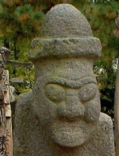
Because of the relative isolation of the island, the people of Jeju have developed a culture and language that are distinct from those of mainland Korea. Jeju is home to thousands of local legends. Perhaps the most distinct cultural artifact is the ubiquitous dol hareubang ("stone grandfather") carved from a block of basalt.
Another distinct aspect of Jeju is the matriarchal family structure, found especially in Udo and Mara, but also present in the rest of the province. The best-known example of this is found among the haenyeo ("sea women"), who were often the heads of families, because they controlled the income. They earned their living from free diving, often all year round in quite cold water, without scuba gear, in order to harvest abalones, conchs, and a myriad of other marine products. It is thought that women are better at spending all day deep-water diving because they resist cold better.[18] However, because of rapid economic development and modernization, few haenyeo are still actively working today.[19][20]
- Bangsatap
Bangsatap are small, round towers made of many stones. There are many Bangsataps and you can see them near the countryside in Jeju. People usually pile up many stones, making a shape like a tower in order to protect themselves from the bad luck in their village. They have built Bangsatap according to the theory of divination because they believe that geography is very important in choosing the right place for them. It is also a good example to demonstrate religious belief in Jeju island because it is an object that people can rely on putting rice paddle inside the Bangsatap to gather as much money as possible and also putting an iron pot to overcome a disaster and fight fire in their village. Nobody knows that when the Bangsatap was built in the past year.
Sports
International competition
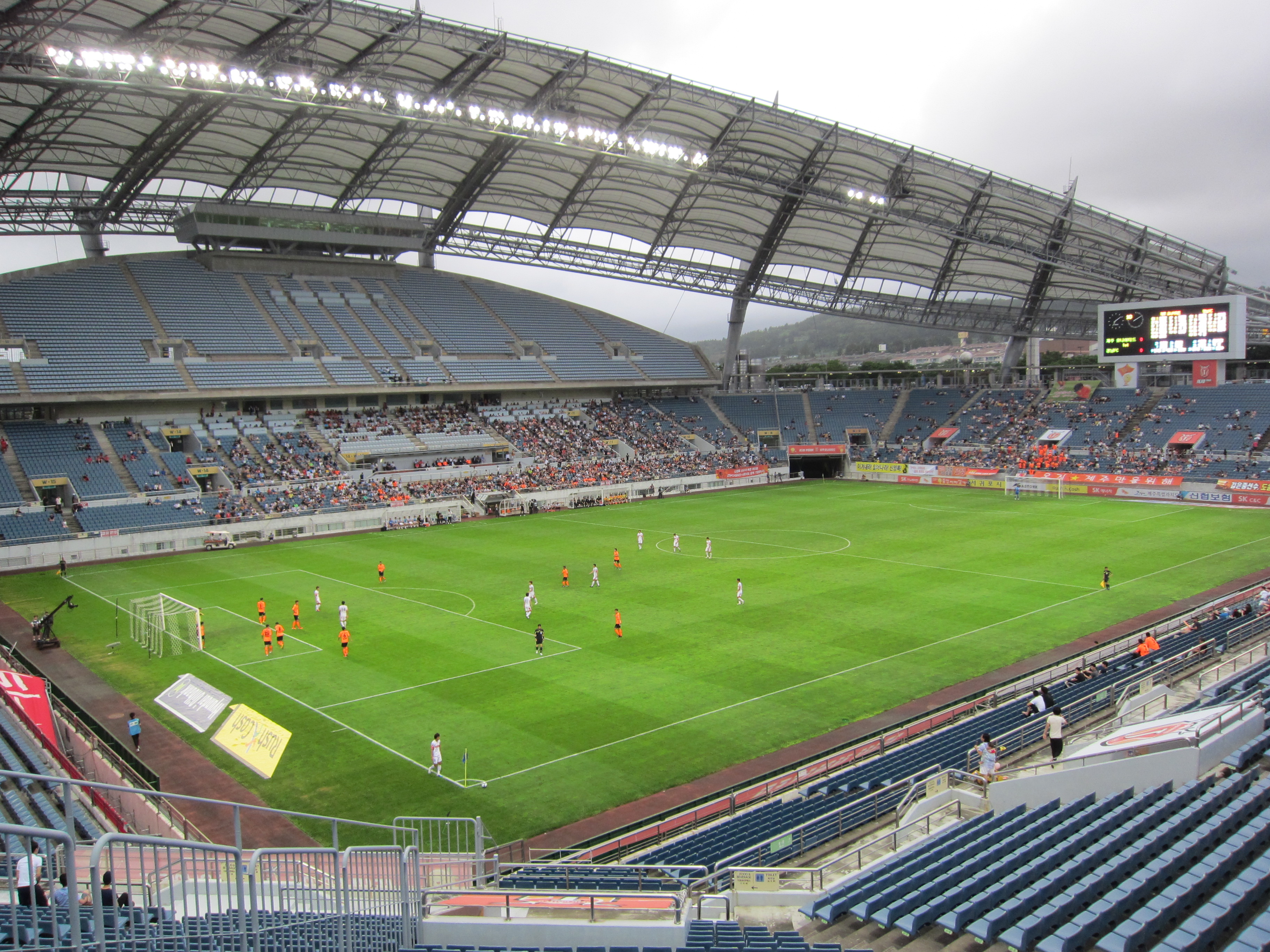
Jeju-do served as one of the host cities of the 2002 FIFA World Cup. Jeju World Cup Stadium hosted some matches
Football
Jeju United is the only one professional sports club of Jeju-do. Jeju United was runners-up of K-League in 2010 recently. Jeju-do have famous high school football tournament.
Cuisine
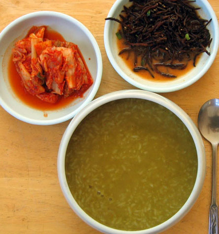
 Jeonbokjuk, abalone porridge
Jeju Island is the southernmost and largest island isolated from the Korean peninsula. Due to its lack of fresh water, paddy farming is only done on a small scale on the island, with the cultivation of cereal crops such as millet, barnyard millet, buckwheat, and barley being the main feature of agriculture. Therefore, the traditional Jeju meal generally consisted of japgokbap which is a bowl of steamed multiple grains as a main dish, with various salted dried fish called jaban[21][22] as banchan (side dishes), and a soup based on doenjang (soybean paste) such as baechuguk made with Napa cabbage, kongnipguk made with soybean leaves, or muguk made with daikon. Jeju dishes are made with simple ingredients, and the taste is generally salty. Raw seafood called hae is commonly consumed as a part of the meal. The warm weather affects Jeju cuisine in that gimjang, preparing kimchi in late autumn for winter consumption, is not necessary to Jeju locals unlike the other provinces. Only a small amount of kimchi is pickled by Jeju locals. Representative main dishes in Jeju cuisine are porridge made with fish, seafood, seaweeds, or mushrooms. Examples include jeonbokjuk made with abalone, okdomjuk made with Red tilefish,[23] gejuk made with crabs, gingijuk made with small crabs called bangge (Helice tridens),[24] maeyeoksae juk made with young wakame,[25] and chogijuk made with shiitake.[26]
Gamgyul is a type of orange similar to the Mandarin orange or tangerine. Black pig is a delicacy on the island. Black pigs are famous for their black hair and their meat for its chewy texture. The meat is chewy and nutritious, but does not have the unique smell of pork. Black pigs other notable features are their long faces, narrow snouts and small ears that stand up.
Myths and legends
The myth of Seulmundae Halmang is well known in Jeju. According to this myth, Seulmundae Halmang (Grandmother Seulmundae) could reach from Sung San Ill Chul Bong to Guan Tal island at Aeweol in a single stride, and with both feet to Mount Halla. She was very strong, had 500 children, and built Mount Halla with seven scoops of earth.
One day, Seulmundae Halmang was making soup for her sons while her sons were out hunting. While they were gone, she fell into the pot and drowned. On their return, they hungrily ate the soup, without knowing that it contained their mother. However, the youngest son knew. He told the truth to the rest of the sons, and the whole family cried, and eventually turned into 500 stones.
Economy
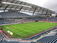 Jeju FIFA World Cup Stadium in Seogwipo
In 2006, the GDP of the province was projected at 8.5 trillion won (about US$8.5 billion), approximately 15 million won per capita. The provincial government's budget for 2006 was projected at 1.1 trillion won, an increase of 10% over 2005.
Jeju is also a home for key functions of Daum Communications,[27] a leading Korean internet site, and sole owner of Lycos.
Jeju is also famous for hosting many conferences and international meetings, including the World Scout Conference in July 2008. Jeju has its own convention center called International Convention Center Jeju. The ASEAN-KOREA Commemorative Summit 2009 was held at ICC Jeju.
Main sights
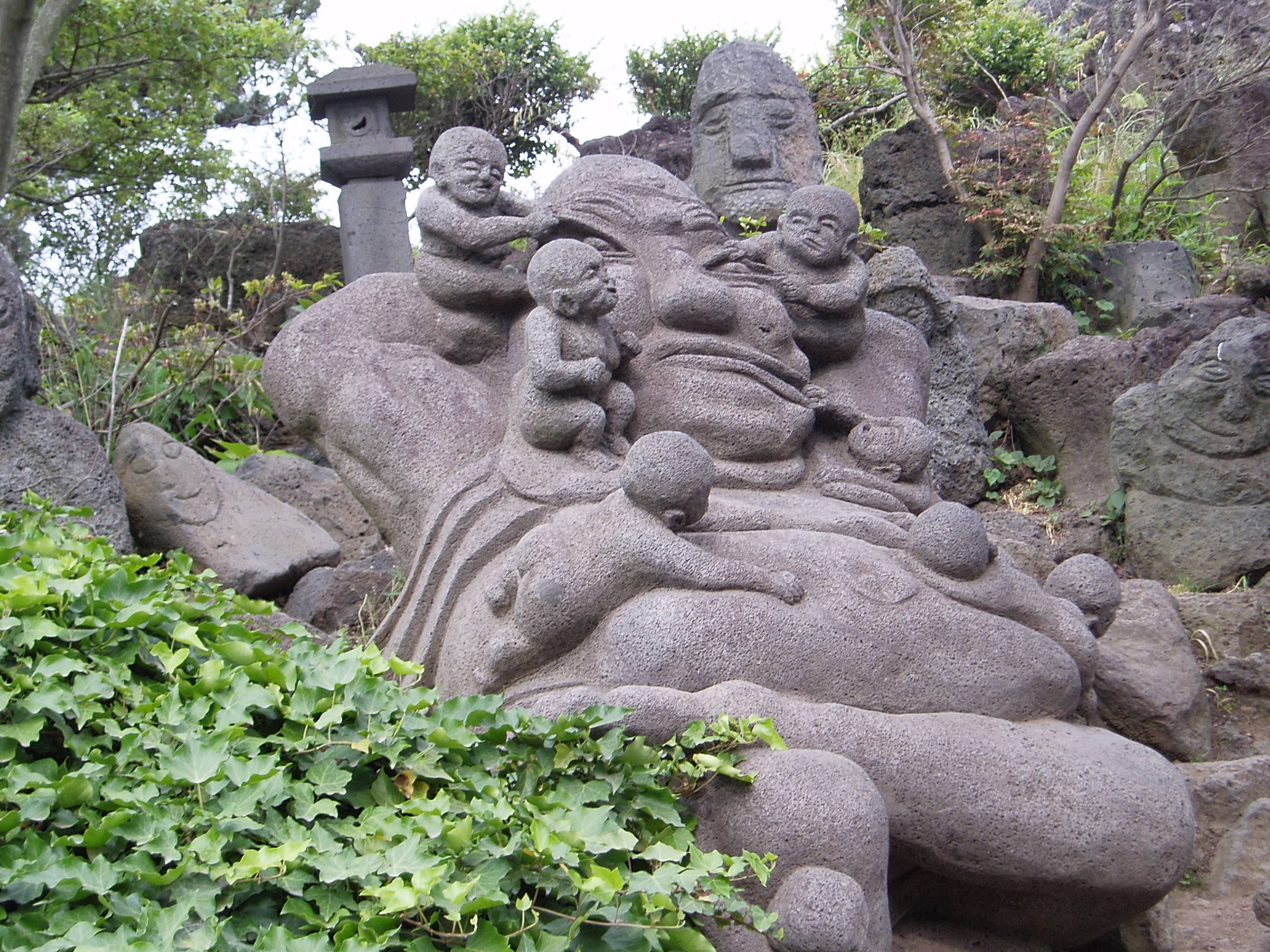
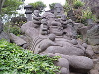 Jeju Stone Statue Park Statue.
Tourism commands a large fraction of Jeju's economy. Jeju's temperate climate, natural scenery, and beaches make it a popular tourist destination for South Koreans as well as visitors from other parts of East Asia. The most popular tourist spots on the island are Cheonjeyeon and Cheonjiyeon waterfalls, Mount Halla, Hyeobje cave, and Hyeongje island. There is a variety of leisure sports that tourists can take part in Jeju including golf, horse riding, hunting, fishing, mountain climbing, etc. Depending on the season, Jeju hosts many festivals for tourists including a penguin swimming contest in winter, cherry blossom festival in spring, the midsummer night beach festival in summer, and Jeju horse festival in autumn, among others. For most tourists, traffic to and from the island is mainly taken through Jeju International Airport and transport within the island by rental cars. Some local products are popular to tourists, including Jeju's special tile fish and mandarin oranges, aside from souvenirs and duty-free shopping.
Jeju was chosen as one of the 28 finalists of the New 7 Wonders of Nature campaign by the New7Wonders Foundation.
Tourist attractions
Hallim Park[28]is one of the oldest and most popular tourist attractions on Jeju. It is located on the west coast of the island.
There is an annual fire festival on the island that stems from a custom of removing harmful insects and old grass in villages every winter. The fire festival is held on the fifteenth day of the first lunar month each year. Dal-gip(to pile up much wood) is burned when the moon rises while praying for good harvests and making good wishes. Jeju traditional food is all eaten at the site of the festival. This festival was held 13 times until 2009. The ""Jeju Jeongwol Daeboreum Fire Festival"" started in 1997 and become a leading festival of Jeju. This takes place in Saebyeol Oreum located in Bongseong ri, Aewol Eup. It takes up 25 minutes from Jeju International Airport by car. Jeju citizens do their utmost to prepare the Fire Festival so as to pass down, develop and ultimately develop branding for the unique folk culture resources of Jeju. Saebyeol oreum has a characteristic of a complex volcano. It has the horseshoe shaped crater that is both very wide and slightly split. Also, it is rising high with the little peaks making oval from the south peak to northwest. The scale is above the sea level 519.3m, height 119m, circumference 2,713m, area 522,216㎡. Saebyeol oreum, which is the middle size among the 360 oreums in Jeju island. It's named after the saying "it brightens like a star".
Olle[29] is a word in the local dialect which refers to the paths between houses and public roads." "Jeju Olle" is a hiking trail founded by Myugsook Suh. called "Olle" is the jeju word for a narrow pathway connected from the house to an open space and has the same sound as "Would you come?" in Korean. The first trail route was opened in September, 2007. There have been 14 opened and the trail exploration team is still working on new routes. There are many route signs. Those are blue arrows and you can fine that on the stone walls of local villages and rocks near the seaside. Blue and yellow ribbons knotted around trees lead travelers on Olle trails.
Manjanggul[30] is one of the longest lava tubes in the world. Manjang Cave, situated at Donggimnyeong-ri, Gujwa-eup, North Jeju, 30 kilometers east of Jeju City, was designated as Natural Monument No. 98 on March 28, 1970. The annual temperature inside the cave ranges from 11℃ to 21℃, thus facilitating a favorable environment throughout the year. The cave is also academically significant as rare species live in the cave. Created by spewing lava, "the lava turtle", "lava pillar", and "Wing-shaped Wall" look like the work of the gods. It is considered to be a world class tourist attraction. The Geomunoreum lava tube system is the most impressive and significant series of protected lava tube caves in the world and includes a spectacular array of secondary carbonate speleothems (stalactites and other formations). And it overwhelms other lava tubes with its abundance and diversity. The Geomunoreum Lava Tube System, which is regarded as the finest such cave system in the world, has an outstanding visual impact even for those experienced with such phenomena. It displays the unique spectacle of multi-colored carbonate decorations adorning the roofs and floors, and dark-colored lava walls, partially covered by a mural of carbonate deposits. In addition, lava tube caves are like those in limestone karst in scale, shape and internal decoration, but completely different in origin. Lava tube caves are known from basaltic terrain in most of the world's volcanic regions. The lava tube caves of the Geomunoreum Lava Tube System are, however, regarded as internationally important due to their length, massive volume, intricate passage configuration, well preserved internal lava features, abundant and spectacular secondary carbonate formations, ease of access, and their scientific and educational values. Another feature making Geomunoreum Lava Tube System globally significant and distinctive is the presence of carbonate deposits and formations. Very small deposits of calcite are common in lava tube caves, and are more significantly developed as speleothems in Duck Creek cave in Utah, USA. However, in abundance, density and diversity they are far less impressive than those of Yongcheongul and Dangcheomuldonggul Lava Tubes in Jeju, and the scale of these decorations within the lava caves of Jeju Island far exceeds any other comparable examples. The nomination is supported by the Commission on Volcanic Caves of the International Union of Speleology - the world's most authoritative scientific body on volcanic caves, which regards Jeju's lava caves as being of the highest international ranking. Yongcheongul Lava Tube has been discovered subsequently and is of equivalent value
Sangumburi Crater[31] is the crater of an extinct volcano. Unlike its brethren Halla-san and Songsan Ilch'ubong, this one exploded quickly, but did not spew much lava nor did it form much of a surrounding cone. This phenomenon is called maru in Korean, and Sangumburi is the only one of its kind in the country, making it Natural Monument #263. The remaining crater is 100 meters deep and an average of 350 meters across. Over 400 species of plants and animals live inside the crater. Visitors can walk around part of the rim (the rest is private property and fenced off), but they cannot venture down inside the crater. A well-paved path leads from the parking area to the viewing area which has a small pavilion and several vista points. Also on the grounds are numerous grave sites made in traditional Jeju fashion: a wide, trapezoidal stone wall surrounding the burial mound. Several of the sites also have small stone figures that guard the mound from evil spirits. At the park entrance are several large rocks from the crater. During the eruption, molten rock flew from the volcano into the air and cooled into many exotic shapes.
Utilities
The island's power-grid is connected to mainland plants by the HVDC Haenam-Cheju, and electricity is also provided by generators located on the island. As of 2001, there were four power plants on Jeju, with more under planning and construction. The most notable of these are the gas-fired generators of Jeju Thermal Power Plant, located in Jeju City. The present-day generators of this plant were constructed from 1982 onwards, replacing earlier structures that dated from 1968.[32] As elsewhere in Korea, the power supply is overseen by the Korea Electric Power Corporation, or KEPCO.
Sister provinces
Jeju's international sister provinces are also islands: Hainan Province (People's Republic of China), Hawaii (U.S.), Sakhalin (Russia), and Bali (Indonesia).
See also
- List of Korea-related topics
- Subdivisions of South Korea
- Geography of South Korea
- Jeju dialect
- Love Land, a sex-themed sculpture park on the island
Notes and references
- ^ Transliterated Korean names are preferred to English equivalents; see Wikipedia:Naming conventions (Korean)#Place names.
- ^ "Unesco names World Heritage sites". BBC News. June 28, 2007. http://news.bbc.co.uk/2/hi/asia-pacific/6248244.stm. Retrieved May 6, 2010.
- ^ Wolcott Wheeler, The 1948 Cheju-do Civil War http://www.kimsoft.com/1997/43wh.htm
- ^ a b c Song Sang-ho (August 7, 2011). "Controversy over Jeju naval base mounts". Korea Herald. http://www.koreaherald.com/national/Detail.jsp?newsMLId=20110807000217.
- ^ a b c Choe Sang-Hun (August 18, 2011). "Island’s Naval Base Stirs Opposition in South Korea". New York Times. http://www.nytimes.com/2011/08/19/world/asia/19base.html?_r=1&pagewanted=all.
- ^ {{cite news |url=http://www.nytimes.com/2011/08/07/opinion/sunday/Steinem-the-arms-race-intrudes-on-a-south-korean-paradise.html?scp=2&sq=steinem&st=nyt |title=The Arms Race intrudes on Paradise|author=Gloria Steinem |work=New York Times |date=August 6, 2011
- ^ Gwisook Gwon (August 14, 2011). "National and International Protests Challenge Naval Base Construction on Jeju Island, South Korea". Asia-Pacific Journal. http://japanfocus.org/-Gwisook-Gwon/3589. Retrieved 2011-08-14.
- ^ Jin-Soo Nam (August 15, 2011). "A Naval Base in South Korea". New York Times. http://www.nytimes.com/2011/08/16/opinion/a-naval-base-in-south-korea.html.(letter to the editor from the Minister-Counselor for Cultural and Public Affairs, Embassy of the Republic of Korea, Washington, August 10, 2011)
- ^ Jeong, Gwang-jung, 2004, Gotjawal and the livelihood of Jeju’s People, 2004, Jeju Educational College, V. 33, pp. 41~65. 정광중, 2004, 곶자왈과 제주인의 삶, 제주교육대학교 논문집. http://www.riss4u.net/link?id=A35499718, page 49
- ^ Yim, Eun-young, 2007, Bryophyte Flora of Dongbaek-dongsan, Jeju-do, Cheju National University, M.A. thesis.. 임은영, 2007, 제주도 동백동산의 선태식물상, 제주대학교 석사학위논문. http://www.riss4u.net/link?id=U10812496_003
- ^ Jang, Yong-chang and Chanwon Lee, 2009, "Gotjawal Forest as an internationally important wetland," Journal of Korean Wetlands Studies, 2009, Vol 1.
- ^ Ramsar site list Accessed June 2009
- ^ "평년값자료(1981−2010) 제주(184)". Korea Meteorological Administration. http://www.kma.go.kr/weather/climate/average_30years.jsp?yy_st=2011&stn=184&norm=M&x=31&y=7&obs=0&mm=5&dd=23. Retrieved 2011−05−23.
- ^ "평년값자료(1981−2010) 서귀포(189)". Korea Meteorological Administration. http://www.kma.go.kr/weather/climate/average_30years.jsp?yy_st=2011&stn=189&norm=M&x=18&y=5&obs=0&mm=5&dd=23. Retrieved 2011−05−23.
- ^ "평년값자료(1981−2010) 성산(188)". Korea Meteorological Administration. http://www.kma.go.kr/weather/climate/average_30years.jsp?yy_st=2011&stn=188&norm=M&x=27&y=11&obs=0&mm=5&dd=23. Retrieved 2011−05−23.
- ^ "평년값자료(1981−2010) 고산(185)". Korea Meteorological Administration. http://www.kma.go.kr/weather/climate/average_30years.jsp?yy_st=2011&stn=185&norm=M&x=22&y=17&obs=0&mm=5&dd=23. Retrieved 2011−05−23.
- ^ "Cheju Consolidation Vote". Korea Times July 28, 2005. http://times.hankooki.com/lpage/opinion/200507/kt2005072817091154050.htm. Retrieved July 29, 2005.
- ^ http://www.scuba-doc.com/coldacclim.html
- ^ http://english.jejusamda.com/common/c_dataView.php?id=F04030500&lang=_eng
- ^ http://www.artinfo.com/news/story/28043/lady-good-divers/
- ^ 자반
- ^ 자반
- ^ 옥돔죽
- ^ 깅이죽
- ^ 매역새우럭국
- ^ 초기죽
- ^ How Daum fell under Jeju's spell, The Jeju Weekly, January 16, 2011
- ^ [1]
- ^ JejuOlle.org
- ^ Manjang Cave, The Jeju Weekly, March 2, 2011
- ^ Sangumburi.net, Korean only
- ^ "Jeju Thermal P/P". Korea Midland Power website. Archived from the original on June 16, 2005. http://web.archive.org/web/20050616082124/http://www.komipo.co.kr/english/komipo/Bran_jeju.asp. Retrieved July 29, 2005.
External links
- Official Site of Korea Tourism Org
- Jeju Island : Official Seoul City Tourism
- Official provincial info site
- Jeju at the Open Directory Project
- English language guide to living on Jeju
- The Jeju Weekly newspaper
Birds found in Jeju island
Jeju 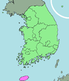
Capital Cities Former counties  Regions and administrative divisions of South Korea
Regions Provinces Special self-governing province JejuSpecial city Metropolitan cities Proposed special autonomous city Amazon Rainforest and River · Halong Bay · Iguazu / Iguaçu Falls · Jeju Island · Komodo Island · Puerto Princesa Underground River · Table Mountain
Categories:- Jeju-do
- Islands of South Korea
- Provinces of South Korea
- Biosphere reserves of South Korea
- 1946 establishments
- Alliance for Healthy Cities
- Autonomous provinces


Wikimedia Foundation. 2010.