- Chungcheongnam-do
-
Coordinates: 36°30′N 126°45′E / 36.5°N 126.75°E
South Chungcheong Province
충청남도
Chungnam忠清南道
Chungcheongnam-do
Emblem of South Chungcheong
Map of South Korea with South Chungcheong highlighted Government Province Capital Daejeon Governor Ahn Hee-jung Dialect Chungcheong Region Hoseo Area 8,598 km²(6th) Population (2005) - Population 1,889,495 (4th) - Density 219 /km² Cities 7 Counties 9 Website chungnam.net (English) Metropolitan Symbols - Flower Chrysanthemum - Tree Weeping Willows - Bird Mandarin Duck Chungcheongnam-do (South Chungcheong) or Chungnam is a province in the west of South Korea. The province was formed in 1896 from the south-western half of the former Chungcheong Province and remained a province of Korea until the country's division in 1945, thereafter becoming part of South Korea. The provincial capital is Daejeon, which is separately administered as a provincial-level metropolitan city.
Chungnam is by far South Korea's fastest growing region, with an average GDP growth of 9.7% in 2001-2007,[1] a figure comparable to China's accelerated growth in the same period. Such rapid growth transformed it from a mostly agricultural to a highly industrialized economy in the 21st century, which has become the wealthiest province in South Korea today, having a GDP per capita of $39,393 in 2008,[2] a level of living standard comparable to wealthy developed countries such as Canada.
Contents
Geography
The province is part of the Hoseo region, and is bounded to the west by the Yellow Sea, to the north by Gyeonggi-do province, to the south by Jeollabuk-do province, and to the east by Chungcheongbuk-do province.
Resources
One third of the province's area is under cultivation. Aside from agriculture, marine products are of importance. There are 220 square kilometres (85 sq mi) of exposed beach which is used to produce salt by solar evaporation. There is coal mining, but gold and silver mines are also found in Chungcheongnam-do, as is Monazite (a rare thorium bearing mineral) and zircon.
Attractions
At 845 metres, Mount Gyeryong is the most notable elevation. It is located in a national park which is noted for its unique rock features. Apart from the stone formations there are a number of old temples. These include Gwanchok-sa, a temple which is home to the largest stone Buddha in Korea.[3] In 1978 the Taean Marine National Park was opened. It includes some of the country's best bathing beaches.
Sejong City
In early 2007, the Republic of Korea government decided to create a special administrative district out of part of the present Chungcheongnam-do Province, near what is presently Daejeon. The new district will be named Sejong Special Autonomous City, and is to replace Seoul as the future capital of the Republic of Korea.
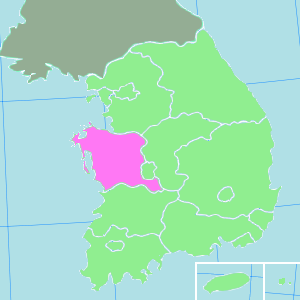
Administrative divisions
Chungcheongnam-do is divided into 7 cities (si) and 9 counties (gun). The city and county names below are given in English, hangul, and hanja.
Cities
- Seosan (서산시, 瑞山市)
- Gyeryong (계룡시, 雞龍市)
Counties
- Buyeo County (부여군, 扶餘郡)
- Cheongyang County (청양군, 青陽郡)
- Dangjin County (당진군, 唐津郡)
- Geumsan County (금산군, 錦山郡)
- Hongseong County (홍성군, 洪城郡)
- Seocheon County (서천군, 舒川郡)
- Taean County (태안군, 泰安郡)
- Yeongi County (연기군, 燕岐郡)
- Yesan County (예산군, 禮山郡)
Famous people
- Hero (Kim Jaejoong); a member of South Korean boy band TVXQ.
- Yesung (Kim Jongwoon); a member of South Korean boy band Super Junior
- Taegoon; pop music singer/dancer
- Yun Dae-nyeong; Author
See also
References
- ^ http://www.mt.co.kr/view/mtview.php?type=1&no=2009072818220114676&outlink=1
- ^ See List of South Korean regions by GDP
- ^ Official Site of Korea Tourism
External links
- Chungcheongnam-do provincial government English-language home page
- Chungcheongnam-do Province English-Language Home Page
South Chungcheong 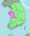
Capital Cities Counties  Regions and administrative divisions of South Korea
Regions Provinces Special self-governing province Special city Metropolitan cities Proposed special autonomous city Categories:- Provinces of South Korea
- Chungcheongnam-do

Wikimedia Foundation. 2010.