- Cheektowaga (town), New York
-
Cheektowaga Town 
Country United States State New York County Erie County Elevation 662 ft (201.8 m) Coordinates 42°54′14″N 78°44′38″W / 42.90389°N 78.74389°W Area 29.5 sq mi (76.4 km2) - land 29.5 sq mi (76 km2) - water 0.0 sq mi (0 km2), 0% Population 94,019 (2000) Density 3,187 / sq mi (1,230.5 / km2) Incorporated 1829 Town Supervisor Mary F. Holtz (D) - Patricia A. Jaworowicz (D)
- Stanley J. Kaznowski, III (D)
- Charlie Markel (D)
- James P. Rogowski (D)
- Jeff Swiatek (D)
- Richard A. Zydel (D)
Timezone EST (UTC-5) - summer (DST) EDT (UTC-4) ZIP code 14225/14227 Area code 716  Location of Cheektowaga in Erie County
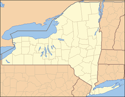
 Location of Cheektowaga in New York
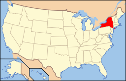 Location of New York in the United States
Website: http://www.tocny.org Cheektowaga is a town (also a Census-designated Place, see below) in Erie County, New York, United States. As of the 2000 census, the town had a total population of 94,019. The name comes from the Iroquoian word Ji-ik-do-wa-gah, meaning the place of the crab apple tree. Cheektowaga has a large Polish-American community, and about 39.9% of population is of Polish heritage.[citation needed]
The Town of Cheektowaga is in the north-central part of the county. It is the second largest suburb of Buffalo, New York next to Amherst.[citation needed] Cheektowaga CDP and Cheektowaga Town contain the site of the Buffalo Niagara International Airport, the principal airport of Erie County.[1]
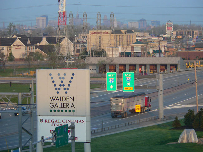
Villa Maria College and the Walden Galleria are located in Cheektowaga.
Contents
History
"Land of the Crabapples" ( JI-IK-DO-WAH-GAH ), named by the Seneca Native Americans referring to the apple-like fruit of the Hawthorn trees abundantly growing in the area. Cheektowaga was formed from Amherst on March 20, 1829, and on the formation of West Seneca on October 16, 1851, was reduced to its present limits—about 33 square miles (85 km2). Throughout the 19th century, it went by its original name: "Chictawauga".
Originally a rural farming area, the town was extensively developed during the post-World War II subdivision boom of the 1950s. Factories, such as the Westinghouse Electric Corporation plant on Genesee Street (since demolished) generated employment to the area for many decades. The town continues to maintain a strong blue collar presence.
In the town there is a complex called the Garden Village Plaza. At one time this was a thriving complex full of retailers but by 2006 this had dwindled down to a few outlets including the Village Flea Market, a Dollar General and T-Birds nightclub. At this time the plaza was acquired by Benderson Development Co for about $2 million from New York City investor Howard Drucker, who had originally asked for $5 million. This deal gained media attention [1] [2] and Benderson vowed to give the location a revamp. However, since that time even more of the businesses have closed and most of the buildings are now derelict. Further talks to develop the site took place in 2010 and 2011. [3] [4]
Other small plazas and malls like Como Mall and Thruway Mall were closed and turned into smaller business plazas with the growing popularity of large shopping malls. The Walden Galleria opened in 1989 in Cheektowaga, the largest mall in the Buffalo Niagara region.
Many people in the area paint their kithcens in the rustic style in this primarily Polish community.
Tornadoes
On July 31, 1987, an F1 tornado touched down in the Union Road and George Urban Boulevard area. It grew to an F2 before dissipating.[2] Homes and business suffered serious damage, but there were no fatalities or severe injuries. This tornado is locally memorable as the one which ripped the roof off the Holiday Showcase Restaurant.
Another F1 tornado touched down not far from the site of the 1987 tornado on June 30, 2006.[3] Again, homes and businesses - including the Holiday Showcase, which was remodeled soon after - were damaged, and a tractor trailer was knocked over on the NY State Thruway, but no one was killed.
Geography
According to the United States Census Bureau, the town has a total area of 29.5 square miles (76.5 km²), all of it land.
The town borders Lancaster on the east, West Seneca on the south, the city of Buffalo on the west, and on the north by Amherst. The town includes the waterways of Scajaquada Creek, Cayuga Creek and Ellicott Creek.
The east town line is marked by New York State Route 78 (Transit Road). New York State Route 240 (Harlem Road) and New York State Route 277 (Union Road) are major north-south routes through the town. New York State Route 33 (Kensington Expressway) and New York State Route 130 (Broadway) access the New York State Thruway, which is also a north-to-south highway through the town (although officially an east-west road, it travels north-south in the Cheektowaga section).
Adjacent Cities & Towns
- City of Buffalo - west
- Town of West Seneca - south
- Village of Depew - east
- Town of Lancaster - east
- Town of Amherst - north
Major Highways in the Town of Cheektowaga

 Interstate 90 (New York State Thruway), runs North-South through the town, traveling from the Amherst town line in the north, south to the West Seneca town line in the southwest corner of town.
 Interstate 190 (Niagara Section), travels in the town from I-90 to Buffalo City Line and beyond into Downtown Buffalo and north to Niagara Falls.
 U.S. Route 20 (Transit Road), North-South roadway that runs concurrently with NY 78 along Cheektowaga's east border with Lancaster, south of Depew.
 New York State Route 78 (Transit Road), North-South roadway that provides the east border of Cheektowaga with Lancaster, north of Depew.
 New York State Route 33 (Kensington Expwy.,Genesee St.), East-West Route that runs through the town from the Buffalo city line as the Kensington Expressway to the Buffalo-Niagara International Airport, which lies within the town. Genesee Street then takes over NY 33 east out of the town into Lancaster.
 New York State Route 130 (Broadway), East-West roadway from the Buffalo city line to the Depew village line.
 New York State Route 240 (Harlem Rd.), North-South roadway from the West Seneca town line, runs along the western town line with Buffalo, and heads north into the Town of Amherst.
 New York State Route 277 (Union Rd.), North-South highway through the town from West Seneca north to Amherst.
 New York State Route 354 (Clinton St.), East-West roadway through the extreme southwest corner of town, and provides the southern border with West Seneca.
- New York State Route 952Q (Walden Ave.), East-West highway through the town from Buffalo to Depew. Walden is the longest non-parkway New York State Reference Route. Walden's reference route number is not signed, but still has reference markers, and is maintained by New York State Department of Transportation (NYSDOT) as other signed routes are.
Demographics
As of the census[4] of 2000, there were 94,019 people, 40,045 households, and 25,869 families residing in the town. The population density was 3,183.8 people per square mile (1,229.3/km²). There were 41,901 housing units at an average density of 1,418.9 per square mile (547.9/km²). The racial makeup of the town was 94.94% White, 2.93% Black or African American, 0.16% Native American, 0.94% Asian, 0.01% Pacific Islander, 0.27% from other races, and 0.75% from two or more races. Hispanic or Latino of any race were 0.97% of the population.
There were 40,045 households out of which 25.5% had children under the age of 18 living with them, 49.5% were married couples living together, 11.4% had a female householder with no husband present, and 35.4% were non-families. 30.4% of all households were made up of individuals and 15.5% had someone living alone who was 65 years of age or older. The average household size was 2.32 and the average family size was 2.91.
In the town the population was spread out with 20.6% under the age of 18, 7.1% from 18 to 24, 28.6% from 25 to 44, 23.2% from 45 to 64, and 20.5% who were 65 years of age or older. The median age was 41 years. For every 100 females there were 88.4 males. For every 100 females age 18 and over, there were 84.6 males.
The median income for a household in the town was $38,121, and the median income for a family was $46,646. Males had a median income of $34,538 versus $25,434 for females. The per capita income for the town was $19,627. About 4.6% of families and 6.5% of the population were below the poverty line, including 8.7% of those under age 18 and 6.4% of those age 65 or over.
Ancestries: Polish (39.9%), German (29.9%), Italian (16.0%), Irish (14.1%), English (5.8%), French (2.7%).
Communities and locations in Cheektowaga
- Bellevue - A neighborhood in between Union Road and the Depew Border. Home to the Bellevue Fire Department and a portion of the Cayuga Creek. Also home to the historic "Bellevue Hotel", a local bar and restaurant which has been in existence since the 19th century.
- Cheektowaga - A cdp within the town.
- Cleveland Hill - A neighborhood located on the north town line, this community has its own school district.
- Depew - The Village of Depew (shared with the Town of Lancaster) is in the eastern part of the town.
- Doyle - A neighborhood near the western town line.
- Forks - A location near Union Road (NY-277) and Broadway (NY-130).
- Maryvale - A neighborhood located just west of the airport, this community is also a school district, containing Maryvale High School.
- Pine Hill - A neighborhood on the border of Buffalo, the community features many cemeteries and Villa Maria College.
- Reinstein Woods Nature Preserve – A conservation area in the south central part of the town.
- Sloan - The Village of Sloan, near the Buffalo border. Sloan has its own school district.
- South Cheektowaga - Neighborhood on the border of West Seneca border near French Road. Several apartment complexes are located in this area.
- U-Crest - A neighborhood near Union Road (NY-277) and Genesee Street (NY-33).
- Williamsville - A small part of the Village of Williamsville (shared with the Town of Amherst).
References
- ^ "Cheektowaga CDP, New York." U.S. Census Bureau. Retrieved on May 25, 2009.
- ^ National Weather Service report on the 1987 tornado (NOAA Website)
- ^ page at the National Weather Service Website discussing the 2006 tornado
- ^ "American FactFinder". United States Census Bureau. http://factfinder.census.gov. Retrieved 2008-01-31.
External links
- Cheektowaga Chamber of Commerce Official Website
- Town of Cheektowaga Official Website
- Cheektowaga Historical Association
- Cheektowaga history
- Maryvale Flyers High School Alumni Page
- Maryvale High
Municipalities and communities of Erie County, New York County seat: Buffalo Cities 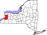
Towns Villages Akron | Alden | Angola | Blasdell | Depew | East Aurora | Farnham | Gowanda‡ | Hamburg | Kenmore | Lancaster | North Collins | Orchard Park | Sloan | Springville | Williamsville
CDPs Other
hamletsAkron Junction | Alden Center | Armor | Athol Springs | Bagdad | Bellevue | Big Tree | Blakeley | Blossom | Boston | Bowmansville | Brant | Brighton | Carnegie | Chaffee | Clarksburg | Cleveland Hill | Clifton Heights | Collins Center | Concord | Creekside | Crittenden | Dellwood | Derby | Doyle | Duells Corner | Dutchtown | East Amherst | East Concord | East Eden | East Elma | East Seneca | Ebenezer | Eden Valley | Eggertsville | Ellicott | Elma | Evans Center | Ferry Village | Footes | Forks | Fowlerville | Gardenville | Getzville | Glenwood | Grandyle Village | Green Acres | Griffins Mills | Holland | Hunts Corners | Jerusalem Corners | Jewettville | Kenilworth | Lake View | Langford | Lawtons | Locksley Park | Loveland | Marilla | Marshfield | Millersport | Millgrove | Morton Corners | Mount Vernon | Murrays Corner | New Ebenezer | New Oregon | North Bailey | North Evans | Oakfield | Patchin | Peters Corners | Pine Hill | Pinehurst | Pontiac | Porterville | Protection | Sand Hill | Sandy Beach | Scranton | Sheenwater | Shirley | Snyder | South Newstead | South Wales | Spring Brook | Swifts Mills | Taylor Hollow | Town Line Station | Swormville | Walden Cliffs | Wales Hollow | Wanakah | Water Valley | Webster Corners | Wende | West Alden | West Falls | Weyer | Williston | Windom | Wolcottsburg | Woodlawn | Woodside | Wyandale | Zoar
Indian
reservationsFootnotes ‡This populated place also has portions in an adjacent county or counties
Categories:- Towns in New York
- Polish American history
- Buffalo – Niagara Falls metropolitan area
- Populated places in Erie County, New York
- Place names in New York of Native American origin


Wikimedia Foundation. 2010.