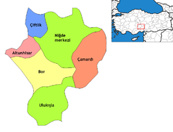
- Niğde
-
Niğde — Town — Niğde Massif Location of Niğde within Turkey. Coordinates: 37°58′N 34°41′E / 37.967°N 34.683°E Country  Turkey
Province Niğde Government - Mayor Faruk Akdoğan (AKP) Population (2010)[1] - Urban 109,724 Time zone EET (UTC+2) - Summer (DST) EEST (UTC+3) Postal code 51xxx Area code(s) 0388 Licence plate 51 Website www.nigde.gov.tr Niğde (Hittite: Nahita Greek: Nigdi) is a small city and the capital of Niğde Province in the Central Anatolia region of Turkey. The population is 109,724 per the [1] 2010 statistics. Elevation is 1,300 m.
The city is located between the volcanic Melandiz Mountains, including the Mount Hasan stratovolcano near the city of Aksaray to the north, and the Niğde Massif to the south-southeast. The massif is a metamorphic dome that contains abandoned antimony and iron mines. Several marble quarries are currently active in the pure white crystalline marble of the massif.
Contents
History
See Niğde Province for a summary of the history of the region, which goes back a long way. This is rich famland near a number of ancient trade routes, particularly the road from Kayseri (ancient Caesarea) to the Cilician Gates. Settlers throughout history include Hittites, Assyrians, Greeks, Romans, Byzantines and finally Turks from 1166 onwards. By the early 13th century Niğde was one of the largest cities in Anatolia. After the fall of the Sultanate of Rûm (of which it had been one of the principal cities), Niğde became independent, and, according to Ibn Battuta, ruinous, and did not pass into Ottoman hands till the time of Mehmet II.
More recent immigrants include Turkish people from Bulgaria and other Balkan countries, who were settled here by the Turkish authorities in the 1950s and 60s.
Climate
Niğde has a semi-arid climate. Niğde has hot and dry summers and cold and snowy winters.
Climate data for Niğde Month Jan Feb Mar Apr May Jun Jul Aug Sep Oct Nov Dec Year Record high °C (°F) 17.2
(63.0)18.5
(65.3)26.2
(79.2)30.8
(87.4)32.0
(89.6)34.0
(93.2)37.8
(100.0)37.8
(100.0)34.6
(94.3)30.6
(87.1)23.5
(74.3)20.9
(69.6)37.8
(100.0)Average high °C (°F) 4.6
(40.3)5.9
(42.6)11.1
(52.0)16.7
(62.1)21.4
(70.5)25.8
(78.4)29.3
(84.7)29.5
(85.1)25.7
(78.3)19.6
(67.3)12.6
(54.7)6.8
(44.2)17.42
(63.35)Average low °C (°F) −4.5
(23.9)−3.6
(25.5)0.0
(32.0)4.7
(40.5)8.5
(47.3)12.1
(53.8)15.0
(59.0)14.7
(58.5)10.5
(50.9)6.2
(43.2)1.2
(34.2)−2.5
(27.5)5.19
(41.35)Record low °C (°F) −21
(−5.8)−24.2
(−11.6)−23.9
(−11.0)−6.9
(19.6)−0.3
(31.5)3.8
(38.8)7.1
(44.8)6.9
(44.4)1.7
(35.1)−0.4
(31.3)−14.7
(5.5)−20.6
(−5.1)−24.2
(−11.6)Precipitation mm (inches) 30.1
(1.185)29.4
(1.157)32.6
(1.283)43.4
(1.709)44.4
(1.748)24.1
(0.949)5.0
(0.197)2.8
(0.11)7.6
(0.299)23.7
(0.933)30.0
(1.181)38.4
(1.512)311.5
(12.264)Avg. rainy days 6 7 7 8 8 4 1 1 1 4 5 7 59 Sunshine hours 120.9 134.4 186 213.9 275.9 333 375.1 356.5 300 229.4 159 117.8 2,801.9 Source no. 1: Devlet Meteoroloji İşleri Genel Müdürlüğü [2] Source no. 2: Hong Kong Observatory [2] Niğde today
Nigde University opened in 1992 and is starting to bring more cultural and social amenities to what is essentially a largish town with a very rural feel to it, providing schools, basic shopping, and other necessities to the surrounding villages. The city is small and there is still plenty of green space and gardens around the houses. The people generally tend to be religious and conservative.
Sight seeing
- Aladağlar and Bolkar Mountains, which are used for mountaineering and trekking
- Aladağlar National Park
- Çiftehan thermal springs
- Gümüşler Monastery, which has been built by Byzantines [3]
- Ancient Tyana City, (Tyana aqueducts and Rome Pool) whose history comes from the B.C. 3. century.
Name etymology
- Nigde means Nowhere in Serbian and Russian languages (нигде in Cyrillic script). These are Slavic languages, related between themselves, but totally unrelated to Turkish.
Notable natives
- Abdullah Durak, footballer
- Nükhet Duru, singer
See also
References
Falling Rain Genomics, Inc. "Geographical information on Nigde, Turkey". http://www.fallingrain.com/world/TU/73/Nigde.html. Retrieved 2008-03-14.
External links
- District governor's official website (Turkish)
- District municipality's official website (Turkish)
- Yesilburç Village
- A web portal of Niğde
Coordinates: 37°58′N 34°41′E / 37.967°N 34.683°E
 Niğde in Niğde Province (in the Central Anatolia region) of Turkey
Urban districts Niğde
Rural districts RegionsAegean Black Sea Central Anatolia Eastern Anatolia Marmara Mediterranean Southeastern Anatolia Categories:- Niğde Province
- Cities in Turkey
- Central Anatolia Region
- Cappadocia
Wikimedia Foundation. 2010.


